Posted:
Nov 26, 2014 @ 6:36 pm

Dangerous snowpack conditions.

Western Montana is getting slammed by heavy mountain snowfall and high ridge top winds.

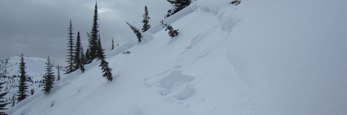
We’ve received several good reports from a variety of locations in the Bitterroot and Rattlesnake mountains all of which describe:

  • a weak snowpack structure
  • heavy new snowfall on top of weak layers of facets
  • cracking and collapsing of the snowpack
  • high winds
  • avalanches on small test slopes and wind loaded terrain

These conditions are particularly dangerous with an upside down profile and a thick slab sitting on the facets that formed during the cold dry weather earlier this month.  Early season avalanches tend to release at the facets close to the ground increasing the likelihood of getting dragged through rocks and stumps if you get caught.

Winter storm watches and warnings are in effect today with clearing conditions for Thanksgiving. We can expect continued snow after Thanksgiving with a return to much colder weather later this weekend.

The best travel advice we can give is to avoid the higher elevation avalanche terrain and give it a chance to strengthen. Keep in mind that it may take more than just a few days before you can trust this weak structure.

This is Steve Karkanen with this early season update from the West Central Montana Avalanche Center issued on November 26, 2014.  We will begin issuing regular advisories with danger ratings on December 12.

READ FULL ADVISORY  

Problem 1 - Wind Slabs

  • TYPE

    wind-slabs

    Wind Slabs

    Release of a cohesive layer of snow (a slab) formed by the wind.  Wind typically erodes snow from the upwind sides of terrain features and deposits snow on the downwind side.  Wind slabs are often smooth and rounded and sometimes sound hollow, and can range from soft to hard. Wind slabs that form over a persistent weak layer (surface hoar, depth hoar, or near-surface facets) may be termed Persistent Slabs or may develop into Persistent Slabs.

  • SIZE

    3-4

    1-2 (Small-Large)

    The potential size of avalanche resulting from this problem.

  • LIKELIHOOD

    Likelihood-7

    Very Likely

    The likelihood of an avalanche resulting from this problem.

  • ADDED DANGER

    Increased Slope Danger

    Increased/Added Danger

    There is an increased risk of avalanches on these slopes:

    N - North
    NE - Northeast
    E - East
    SE - Southeast
    S - South
    NW - Northwest

High W-SW winds have created sensitive wind slabs on leeward terrain.

Problem 2 - Storm slab above facets

  • TYPE

    storm-slabs

    Storm Slabs

    Release of a soft cohesive layer (a slab) of new snow which breaks within the storm snow or on the old snow surface. Storm-slab problems typically last between a few hours and few days. Storm-slabs that form over a persistent weak layer (surface hoar, depth hoar, or near-surface facets) may be termed Persistent Slabs or may develop into Persistent Slabs.

  • SIZE

    3-4

    1-2 (Small-Large)

    The potential size of avalanche resulting from this problem.

  • LIKELIHOOD

    Likelihood-5

    Likely

    The likelihood of an avalanche resulting from this problem.

  • ADDED DANGER

    Increased Slope Danger

    Increased/Added Danger

    There is an increased risk of avalanches on these slopes:

    N - North
    NE - Northeast
    E - East
    SE - Southeast
    S - South
    SW - Southwest
    W - West
    NW - Northwest

The most recent storm snow and wind is causing widespread instability.  A weak layer of facets formed during the cold weather earlier this month and needs time to adjust to the new load.

FORECAST & OUTLOOK

Winter storm watches and warnings are in effect today with clearing conditions for Thanksgiving. We can expect continued snow after Thanksgiving with a return to much colder weather later this weekend.

This information is the sole responsibility of the Forest Service and does not apply to operating ski areas. The avalanche danger rating expires at midnight tonight but the information can help you make a more informed decision regarding travel in avalanche terrain for the next few days.

Our advisory area includes National Forest System lands in the Bitterroot Mountains from Lost Trail Pass north to Granite Pass, the Rattlesnake Mountains north of Missoula and the Southern Swan and Mission Mountains near Seeley Lake, MT. Avalanche information for the Lookout Pass/St. Regis Basin area is available from the Idaho Panhandle Avalanche Center.