Posted:
Jan 2, 2015 @ 7:01 am

The avalanche danger is CONSIDERABLE on wind loaded terrain steeper than 35 degrees. High winds earlier this week formed sensitive wind slabs on multiple aspects above 6000 feet. Natural avalanches are possible, human triggered avalanches are likely.  Careful snowpack evaluation, cautious route finding and conservative decision making are essential under these conditions.

Hello! This is Steve Karkanen with the backcountry avalanche advisory for Friday, January 2, 2015. The danger rating expires at midnight and does not apply to operating ski areas.


Weather and Snowpack

Mountain temperatures this morning are in the teens and twenties with a northwest wind gusting to 27 mph at 8000 feet. Skies are cloudy and snow is expected later today.

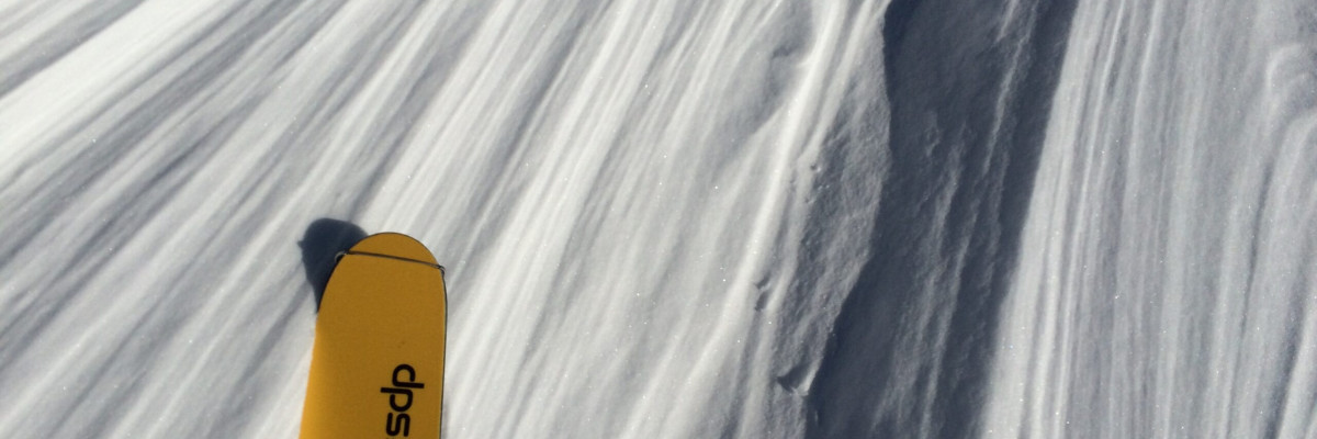
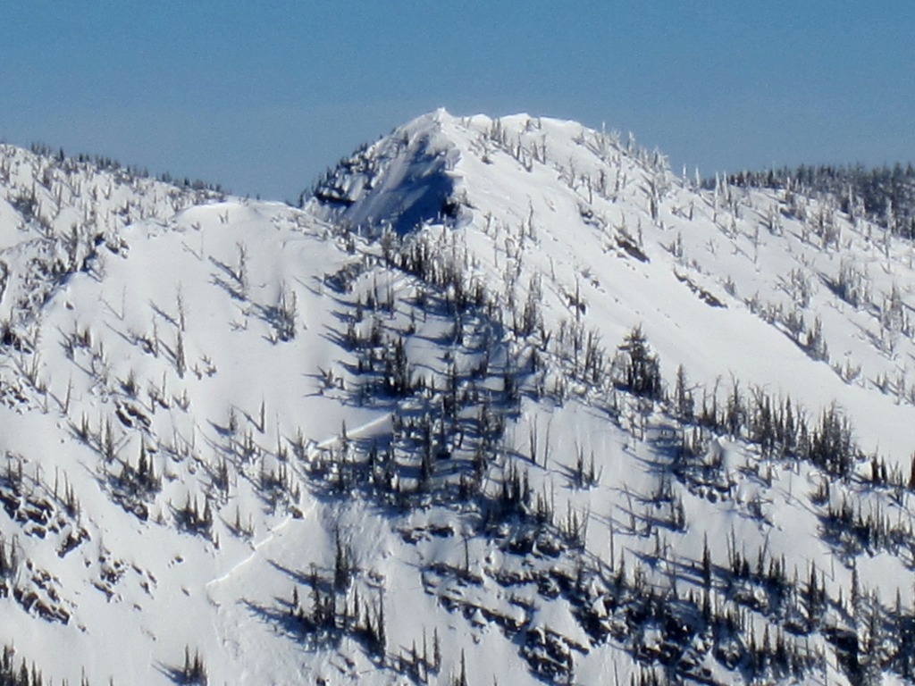
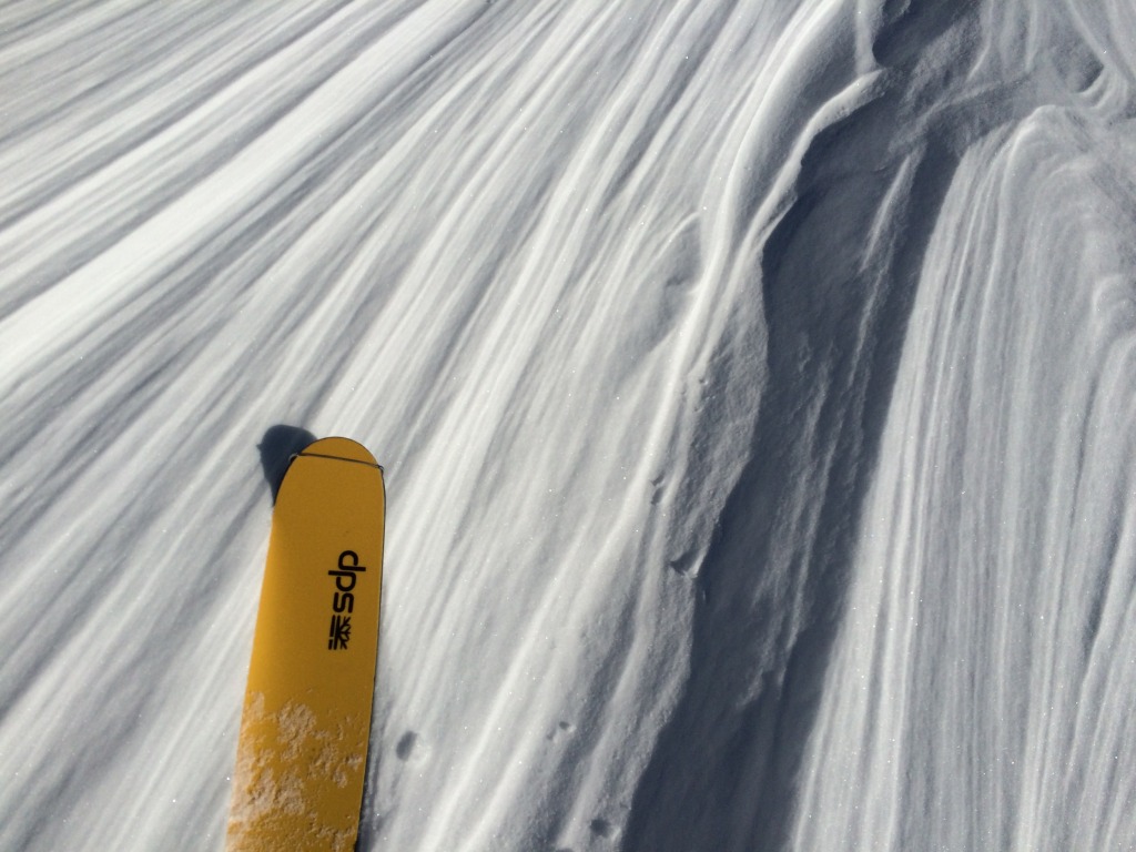
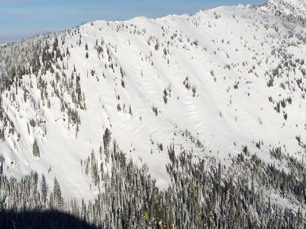
Earlier this week, high winds hammered mountain peaks and ridges with 50 mph winds. North and east aspects were hit hard as the wind scoured these slopes and loaded others. On our Rattlesnake tour we saw a large recent avalanche on a south aspect rocky slope that was heavily cross loaded during the wind.  The recent blast of wind and cold temperatures, recent avalanches and fracture propagation during stability testing are the factors keeping the danger rating elevated.

Any steep wind loaded area, including cross loaded terrain lower on a slope, is potentially dangerous right now.

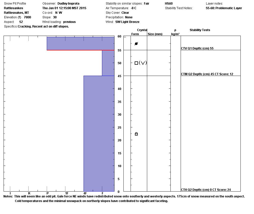
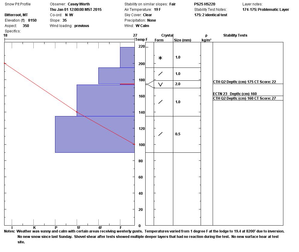
The cold and clear weather has also created another weak layer on or just under the surface that will demand our attention during the next storm. There are also pockets where the wind stripped the snow down to the ground. These thin areas are prone to faceting and already have a weak structure (see profile below).

Conditions were less than ideal for travel and downright heinous for skiing yesterday. Overall stability has improved but the wind sculpted interesting patterns and left a few landmines on top and cross loaded slopes. We also remain concerned about the deeply weak layer we’ve been talking about for nearly a month now. It takes a lot of force but it snaps with energy when it fails. This is the layer that failed in the recent avalanche near Seeley Lake.

As it so clearly demonstrated last weekend, it can’t be trusted.


Weather Forecast and Avalanche Outlook

The Missoula Weather Service Office is forecasting more active weather with slightly warmer temperatures and a few inches of snow. By Saturday night, a series of wet systems will push into the area with up to a foot of mountain snow possible. 20-30 mph winds are possible as the front passes.

We have a weak snow surface and a deep persistent weak layer that gets touchy every time it snows. The avalanche danger will increase with heavy new snow and high wind.

Dudley will issue the next advisory on Tuesday, January 6.

READ FULL ADVISORY  

Problem 1 - Wind Slabs

  • TYPE

    wind-slabs

    Wind Slabs

    Release of a cohesive layer of snow (a slab) formed by the wind.  Wind typically erodes snow from the upwind sides of terrain features and deposits snow on the downwind side.  Wind slabs are often smooth and rounded and sometimes sound hollow, and can range from soft to hard. Wind slabs that form over a persistent weak layer (surface hoar, depth hoar, or near-surface facets) may be termed Persistent Slabs or may develop into Persistent Slabs.

  • SIZE

    3-4

    1-2 (Small-Large)

    The potential size of avalanche resulting from this problem.

  • LIKELIHOOD

    Likelihood-3

    Possible

    The likelihood of an avalanche resulting from this problem.

  • ADDED DANGER

    Increased Slope Danger

    Increased/Added Danger

    There is an increased risk of avalanches on these slopes:

    N - North
    NE - Northeast
    E - East
    SE - Southeast
    S - South
    SW - Southwest
    W - West
    NW - Northwest

  • IMAGE

The wind has sculpted an avalanche problem for nearly every aspect.

Problem 2 - Buried Surface Hoar

  • TYPE

    persistent-slabs

    Persistent Slabs

    Release of a cohesive layer of soft to hard snow (a slab) in the middle to upper snowpack, when the bond to an underlying persistent weak layer breaks.  Persistent layers include: surface hoar, depth hoar, near-surface facets, or faceted snow. Persistent weak layers can continue to produce avalanches for days, weeks or even months, making them especially dangerous and tricky. As additional snow and wind events build a thicker slab on top of the persistent weak layer, this avalanche problem may develop into a Persistent, Deep-Slab.

  • SIZE

    3-4

    1-2 (Small-Large)

    The potential size of avalanche resulting from this problem.

  • LIKELIHOOD

    Likelihood-3

    Possible

    The likelihood of an avalanche resulting from this problem.

  • ADDED DANGER

    Increased Slope Danger

    Increased/Added Danger

    There is an increased risk of avalanches on these slopes:

    N - North
    NE - Northeast
    E - East
    SE - Southeast
    S - South
    SW - Southwest
    W - West
    NW - Northwest

This weak layer is about 3 feet deep in most areas above 6000 feet. Stability tests are still showing propagation ECTP22 (see video).

VIDEO

New Years Day 2015 in the Rattlesnake Wilderness. Extended Column Test on 20 degree south slope at 8000′. ECTP22 fails on the facets that formed in early December.

New Years Day 2015 in the Rattlesnake Wilderness. Pictures depict the type of terrain where it is likely to trigger an avalanche.

FORECAST & OUTLOOK

We have a weak snow surface and a deep persistent weak layer that gets touchy every time it snows. The avalanche danger will increase with heavy new snow and high wind.

This information is the sole responsibility of the Forest Service and does not apply to operating ski areas. The avalanche danger rating expires at midnight tonight but the information can help you make a more informed decision regarding travel in avalanche terrain for the next few days.

Our advisory area includes National Forest System lands in the Bitterroot Mountains from Lost Trail Pass north to Granite Pass, the Rattlesnake Mountains north of Missoula and the Southern Swan and Mission Mountains near Seeley Lake, MT. Avalanche information for the Lookout Pass/St. Regis Basin area is available from the Idaho Panhandle Avalanche Center.