Posted:
Feb 21, 2015 @ 7:51 am

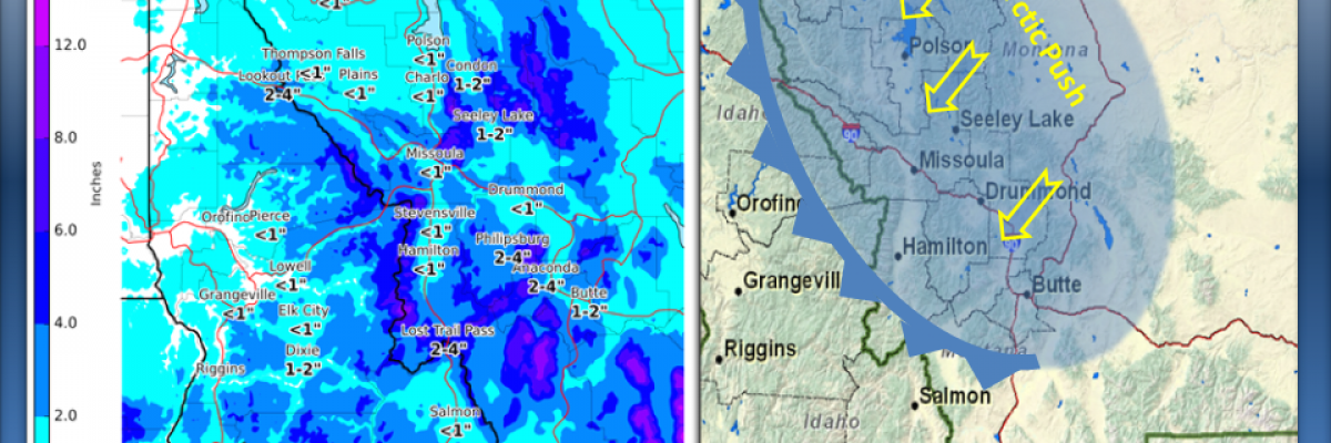
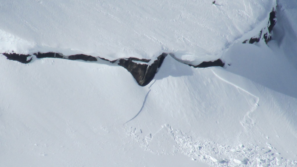
New snow overnight with high E-NE winds has increased the avalanche danger to MODERATE at all mountain locations in west central Montana.  The Rattlesnake and southern Missions received 10 and 14 inches respectively with 2 to 4 inches in the Bitterroot mountains.  A 30mph east wind (Point Six RAWS) is already impacting the higher terrain this morning and is expected to increase throughout today and Sunday. Expect the avalanche danger to ramp up to CONSIDERABLE on ANY recently wind loaded slope steeper than 35 degrees.

Good morning, this is Steve Karkanen with an avalanche conditions update from the West Central Montana Avalanche Center.

Well, that didn’t last long.  We finally made it to generally safe (LOW danger) conditions but this Arctic air and precipitation have changed the outlook.  The area of most concern is in the mountains north of Missoula and around Seeley Lake. The snow surface conditions and a weak layer underlying the sun crust will be problematic for the next few days.  Strong east winds are moving the new snow onto lee terrain so expect to find wind slabs in unusual locations today.

I will issue the next regular advisory on Monday Feb 23.  If you get out and see something interesting, let us know. Your observations are very helpful and may save a life.

READ FULL ADVISORY  

Problem 1 - Sensitive wind slabs

  • TYPE

    wind-slabs

    Wind Slabs

    Release of a cohesive layer of snow (a slab) formed by the wind.  Wind typically erodes snow from the upwind sides of terrain features and deposits snow on the downwind side.  Wind slabs are often smooth and rounded and sometimes sound hollow, and can range from soft to hard. Wind slabs that form over a persistent weak layer (surface hoar, depth hoar, or near-surface facets) may be termed Persistent Slabs or may develop into Persistent Slabs.

  • SIZE

    3-4

    1-2 (Small-Large)

    The potential size of avalanche resulting from this problem.

  • LIKELIHOOD

    Likelihood-4

    Possible/Likely

    The likelihood of an avalanche resulting from this problem.

  • ADDED DANGER

    Increased Slope Danger

    Increased/Added Danger

    There is an increased risk of avalanches on these slopes:

    S - South
    SW - Southwest
    W - West
    NW - Northwest

  • MAP

    10" to 14" new snow with 30+mph east wind

    Rattlesnake and Missions received 10-14 inches new snow overnight.

New wind slabs will be touchy on steep terrain.

Problem 2 - Storm snow

  • TYPE

    storm-slabs

    Storm Slabs

    Release of a soft cohesive layer (a slab) of new snow which breaks within the storm snow or on the old snow surface. Storm-slab problems typically last between a few hours and few days. Storm-slabs that form over a persistent weak layer (surface hoar, depth hoar, or near-surface facets) may be termed Persistent Slabs or may develop into Persistent Slabs.

  • SIZE

    2-3

    1 (Small)

    The potential size of avalanche resulting from this problem.

  • LIKELIHOOD

    Likelihood-3

    Possible

    The likelihood of an avalanche resulting from this problem.

  • ADDED DANGER

    Increased Slope Danger

    Increased/Added Danger

    There is an increased risk of avalanches on these slopes:

    N - North
    NE - Northeast
    E - East
    SE - Southeast
    S - South
    SW - Southwest
    W - West
    NW - Northwest

The initial storm snow came in wet and dense so it most likely bonded to the icy snow surface. You need to verify this before jumping into something steep.

Pics and profiles from Thursday.

FORECAST & OUTLOOK

From the Missoula Weather Service Office backcountry forecast for WCMT:

DISCUSSION: A much colder, arctic airmass with origins in central
Canadian provinces has begun settling over Montana overnight and
will continue pushing much colder air westward into Idaho through
the day. New snowfall accumulations overnight won't have much time
to settle, as winds will be on the steady increase today into
Sunday. Lower elevations conducive to funneling east winds will
see the typical easterly push from this arctic air...with mid and
upper elevations seeing an increase in winds on a bit of a time
lag. Ridgetop winds late Saturday into early Sunday will switch
to north-northeasterly and increase quite a bit...becoming the
dominant backcountry impact for the rest of the weekend. While
there will be plenty of sunshine, don't let it deceive you; the
winds will be cranking all the while. -Allegretto

This information is the sole responsibility of the Forest Service and does not apply to operating ski areas. The avalanche danger rating expires at midnight tonight but the information can help you make a more informed decision regarding travel in avalanche terrain for the next few days.

Our advisory area includes National Forest System lands in the Bitterroot Mountains from Lost Trail Pass north to Granite Pass, the Rattlesnake Mountains north of Missoula and the Southern Swan and Mission Mountains near Seeley Lake, MT. Avalanche information for the Lookout Pass/St. Regis Basin area is available from the Idaho Panhandle Avalanche Center.