Posted:
Mar 27, 2015 @ 6:38 am

On slopes above 7000 feet and steeper than 35 degrees the avalanche danger in the west central Montana backcountry is rated at moderate. It is possible to trigger small to moderately sized wet, loose slides. The chances of human triggered and natural wet releases will rise with today’s afternoon temperatures. Also in the higher, steep terrain, leeward aspects may harbor wind slabs from the storms that occurred earlier this week.

Good morning, this is Dudley Improta with the West Central Montana Avalanche Center’s advisory for Friday, March 27, 2015. This danger rating does not apply to operating ski areas and expires at midnight tonight. This is our last regularly scheduled advisory for the season.

Weather and Snowpack

Well, all it took to get up to a foot of snow in the mountains, was for the Avalanche Center to announce the end of the season and not issue a Tuesday advisory this week.  If we had known it would be this easy, we would have done this in February.

It should be a pleasant day with dry conditions and near record high temperatures. Mountain temperatures are already well above freezing. Above 7000 feet, west and southwest winds are blowing 10-15mph and gusting in the 20’s.

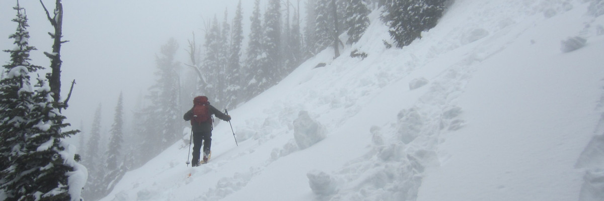
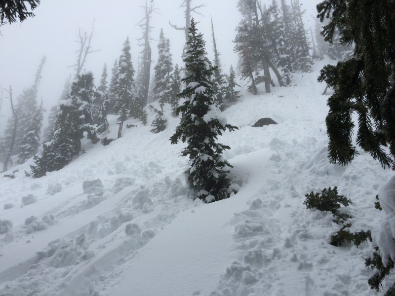
Storms this week produced a welcome 8 to 12 inches of snow. We got a nice report from Downing Mountain Lodge on Wednesday about excellent riding conditions and elevated avalanche hazard in the Bitterroots. The main concerns were medium-sized, loose snow slides and wind slabs up to 10 inches. Steve and I toured in the Rattlesnakes yesterday and found the new snow has become a bit heavy and easily moves down the hill in loose, wet sluffs. These slides are substantial enough to trip up a day-dreaming skier and possibly cause a problem. The warm temperatures will increase the chances of a wet release.

Weather and Avalanche Outlook

Today may see temperatures 15 to 20 degrees (F) above normal. Warm temperatures will increase the chance of natural and triggered wet releases. Outdoor enthusiasts heading out for the weekend should not be lulled into complacency by today’s balmy weather. Cooler temperatures, lowering snow levels and strong ridgetop winds are forecast for Saturday. A modest amount of snow, 2 to 5 inches, is predicted in the mountains. With dropping temperatures, possible snow and increased wind, I would expect the chances for wet slides to decrease and the chances for wind slabs to increase.

Thanks!

This is our last regularly scheduled advisory for the season. We will issue a spring bulletin in the next few days. The West Central Montana Avalanche Center and missoulaavalanche.org (our non-profit friends group) sincerely appreciates the support we get from the west central Montana community.

Ride and ski safe. Have a great weekend.

READ FULL ADVISORY  

Problem 1 - Wet slides

  • TYPE

    loose-wet

    Loose Wet

    Release of wet unconsolidated snow or slush. These avalanches typically occur within layers of wet snow near the surface of the snowpack, but they may quickly gouge into lower snowpack layers. Like Loose-Dry Avalanches,they start at a point and entrain snow as they move downhill, forming a fan-shaped avalanche. They generally move slowly, but can contain enough mass to cause significant damage to trees, cars or buildings. Other names for loose-wet avalanches include point-release avalanches or sluffs. Loose-wet avalanches can trigger slab avalanches that break into deeper snow layers.

  • SIZE

    3-4

    1-2 (Small-Large)

    The potential size of avalanche resulting from this problem.

  • LIKELIHOOD

    Likelihood-3

    Possible

    The likelihood of an avalanche resulting from this problem.

  • IMAGE

Wet, loose slides are possible on steep terrain (>35 degrees). Warm temperatures this afternoon (Friday) will increase the chances of these wet releases.

Problem 2 - Lingering wind slabs

  • TYPE

    wind-slabs

    Wind Slabs

    Release of a cohesive layer of snow (a slab) formed by the wind.  Wind typically erodes snow from the upwind sides of terrain features and deposits snow on the downwind side.  Wind slabs are often smooth and rounded and sometimes sound hollow, and can range from soft to hard. Wind slabs that form over a persistent weak layer (surface hoar, depth hoar, or near-surface facets) may be termed Persistent Slabs or may develop into Persistent Slabs.

  • SIZE

    2-3

    1 (Small)

    The potential size of avalanche resulting from this problem.

  • LIKELIHOOD

    Likelihood-2

    Unlikely/Possible

    The likelihood of an avalanche resulting from this problem.

Storms from earlier this week came in with strong winds; there is still the potential to trigger a small wind slab on leeward slopes.

FORECAST & OUTLOOK

Today may see temperatures 15 to 20 degrees (F) above normal. Warm temperatures will increase the chance of natural and triggered wet releases. Outdoor enthusiasts heading out for the weekend should not be lulled into complacency by today’s balmy weather. Cooler temperatures, lowering snow levels and strong ridgetop winds are forecast for Saturday. A modest amount of snow, 2 to 5 inches, is predicted in the mountains. With dropping temperatures, possible snow and increased wind, I would expect the chances for wet slides to decrease and the chances for wind slabs to increase.

This information is the sole responsibility of the Forest Service and does not apply to operating ski areas. The avalanche danger rating expires at midnight tonight but the information can help you make a more informed decision regarding travel in avalanche terrain for the next few days.

Our advisory area includes National Forest System lands in the Bitterroot Mountains from Lost Trail Pass north to Granite Pass, the Rattlesnake Mountains north of Missoula and the Southern Swan and Mission Mountains near Seeley Lake, MT. Avalanche information for the Lookout Pass/St. Regis Basin area is available from the Idaho Panhandle Avalanche Center.