Posted:
Nov 28, 2015 @ 6:21 am

Hi everyone, this is Logan King at the West Central Montana Avalanche Center with early season avalanche safety information issued Saturday, November 28, 2015.

Winds have dropped off since Thursday morning as the tail end of the arctic front passed through and no new snow has accumulated as the region has been dominated by a high pressure system resulting in cold temperatures and clear skies.

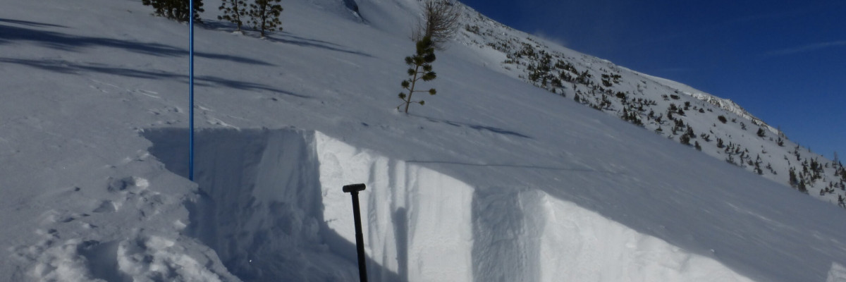
Currently the main concern is wind slabs, with the strong and variable winds that we received during the frontal passage you can expect to find these slabs on variable aspects and through all elevations. Due to the unusual distribution close assessment will be critical and terrain management will be very important in avoiding these slabs.

With the stable weather pattern the storm slab instabilities should be settling out. That said, we have been seeing highs in the 20’s and lows in the single digits through the last few nights with minimal wind. With these cold temps you can expect to see some facet development especially where the snowpack is shallow (which is the majority of the region). Keep an eye on these facets as they may become reactive as their strength decreases or a new load is introduced. Surface hoar will likely develop as well with the current conditions and will become a problem when it becomes buried.

These early conditions have the potential to set the tone for the remainder of the season so now is a great time to brush up on your avalanche skills. There are a multitude of education opportunities coming up and it never hurts to get the avy gears turning in your head early (education page). If you get out please feel free to share your observations through our public obs page. 

READ FULL ADVISORY  

Problem 1 - Wind Slabs

  • TYPE

    wind-slabs

    Wind Slabs

    Release of a cohesive layer of snow (a slab) formed by the wind.  Wind typically erodes snow from the upwind sides of terrain features and deposits snow on the downwind side.  Wind slabs are often smooth and rounded and sometimes sound hollow, and can range from soft to hard. Wind slabs that form over a persistent weak layer (surface hoar, depth hoar, or near-surface facets) may be termed Persistent Slabs or may develop into Persistent Slabs.

  • SIZE

    3-4

    1-2 (Small-Large)

    The potential size of avalanche resulting from this problem.

  • LIKELIHOOD

    Likelihood-3

    Possible

    The likelihood of an avalanche resulting from this problem.

Wind slabs are still the greatest concern. Keep in mind that these wind slabs have an unusual distribution and may be found in areas where you are not accustomed to seeing them.

Problem 2 - Facet Development

  • TYPE

    persistent-slabs

    Persistent Slabs

    Release of a cohesive layer of soft to hard snow (a slab) in the middle to upper snowpack, when the bond to an underlying persistent weak layer breaks.  Persistent layers include: surface hoar, depth hoar, near-surface facets, or faceted snow. Persistent weak layers can continue to produce avalanches for days, weeks or even months, making them especially dangerous and tricky. As additional snow and wind events build a thicker slab on top of the persistent weak layer, this avalanche problem may develop into a Persistent, Deep-Slab.

  • SIZE

    2-3

    1 (Small)

    The potential size of avalanche resulting from this problem.

  • LIKELIHOOD

    Likelihood-3

    Possible

    The likelihood of an avalanche resulting from this problem.

The temperatures for the next few days should not be as cold as they have been for the past 48 hours but will still be sufficient for the development of facets in the snowpack, especially where the snowpack is thin.

FORECAST & OUTLOOK

There is no significant change in the weather for a few days, and we can expect to continue to see cold temperatures with mostly clear skies.

This information is the sole responsibility of the Forest Service and does not apply to operating ski areas. The avalanche danger rating expires at midnight tonight but the information can help you make a more informed decision regarding travel in avalanche terrain for the next few days.

Our advisory area includes National Forest System lands in the Bitterroot Mountains from Lost Trail Pass north to Granite Pass, the Rattlesnake Mountains north of Missoula and the Southern Swan and Mission Mountains near Seeley Lake, MT. Avalanche information for the Lookout Pass/St. Regis Basin area is available from the Idaho Panhandle Avalanche Center.