Posted:
Jan 30, 2016 @ 6:30 am

The current avalanche danger is Considerable in the west central Montana backcountry on wind loaded slopes greater than 35 degrees.  For other slopes in the advisory area the danger is moderate.  This means careful snowpack evaluation, cautious route-finding and conservative decision-making are essential to recreate today.

Good morning, this is Travis Craft with the West Central Montana Avalanche Center’s avalanche advisory for January 30, 2016.  This danger rating does not apply to operating ski areas, expires at midnight tonight and is the sole responsibility of the U.S. Forest Service.

Weather and Snowpack

Mountain temperatures range from 17 F to 25 F in the region.  Winds are 11 mph with gusts of 16 mph out of the SSW in the Bitterroot.  The area has received between 2 to 7 new inches of snow in the last 24 hours.

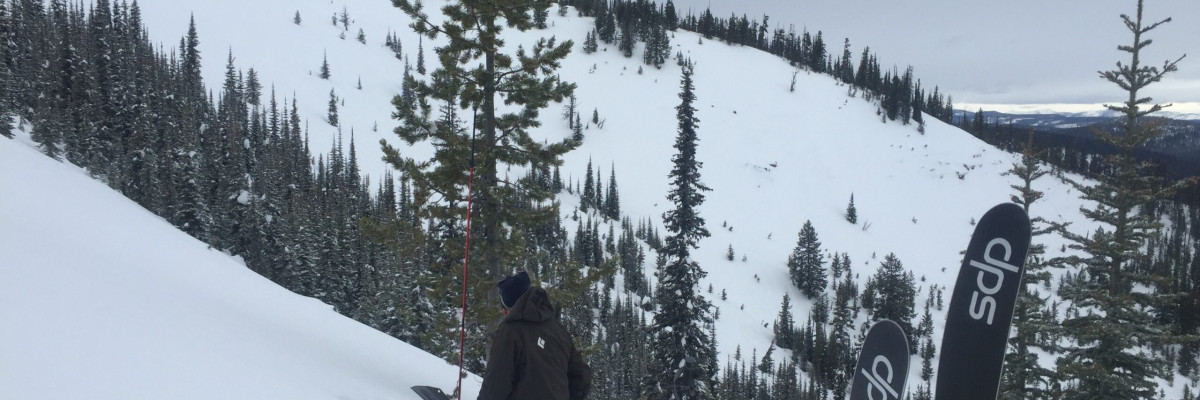
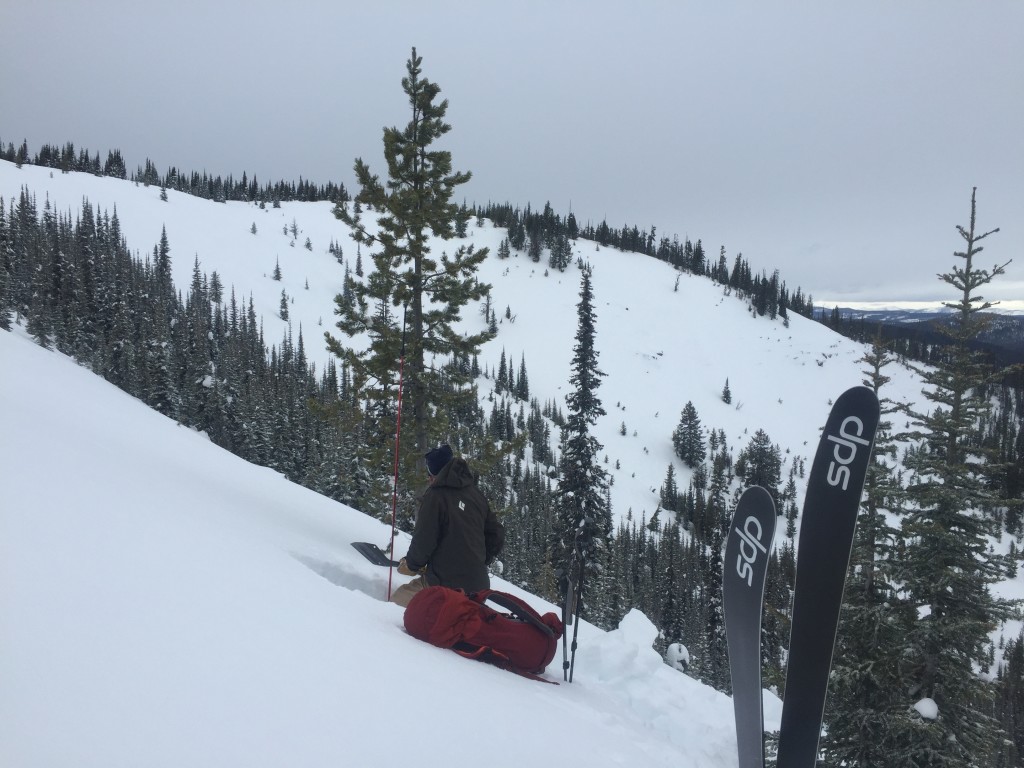
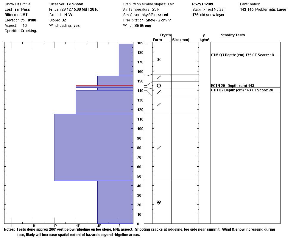
The first avalanche problem today are wind slabs.  The new snow came in with high winds which have placed wind slabs on leeward terrain.  Ed reported shooting cracks on ridges in the southern Bitterroot.  Matt was in the Lolo pass area and found freshly deposited wind slabs on leeward terrain.

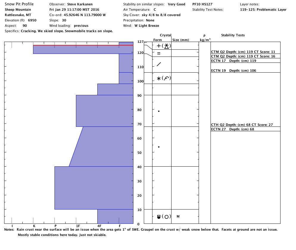
The second avalanche problem are loose dry avalanches.  The new snow has been deposited on weak snow surfaces created by previous warm temperatures.  At elevations below 7600 ft., we have a rain crust and above 7600 ft., we have new snow layers that are weak.  With additional snow loading expect these loose dry avalanches to start to form storm slabs.

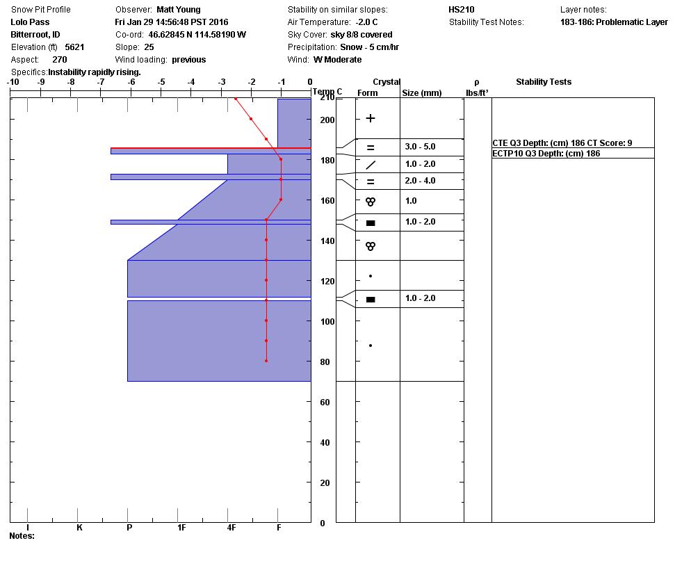
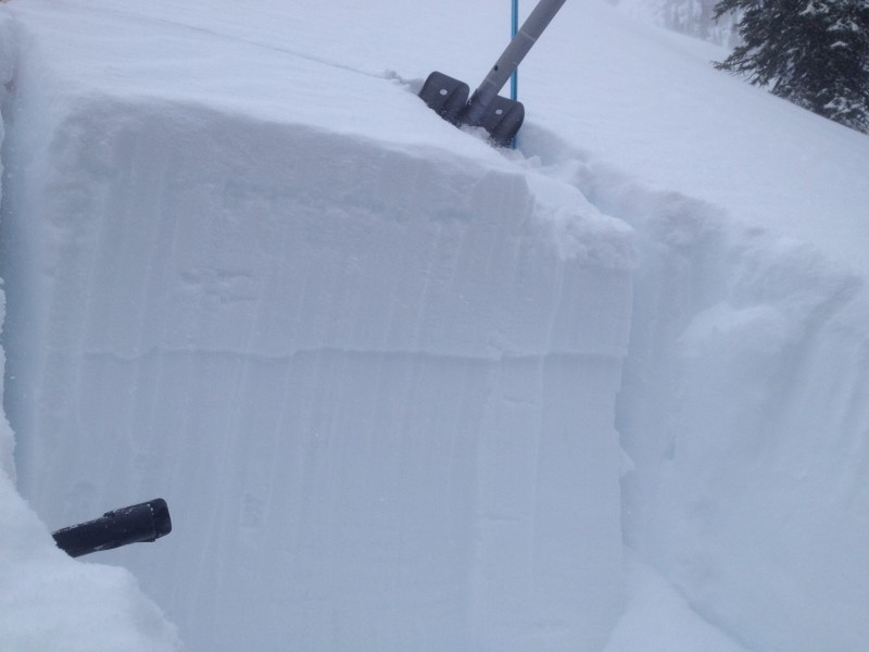
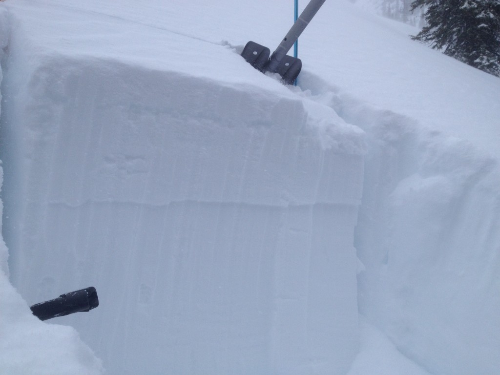
The last avalanche concern are persistent slabs.  The layer of concern is a cold preserved layer of snow in our snowpack and it is varying in depth in the advisory area between 30cm and 40cm.  It is getting clean failures in compression tests and will propagate on some aspects.  Brian was able to find this layer in the Rattlesnake and got it to propagate in an ECT.  Steve and I found this layer near Sheep Mountain and could not get it to propagate.  With the new load of snow, dig a pit to see if this layer is  reactive.

Weather and Avalanche Outlook

The forecast is calling for snow banding events today.  These are events that could produce 1 to 4 inches in a short time and could be accompanied with high winds.  This will increase the avalanche hazard.  Pay attention to changing conditions while recreating today.

Ski and ride safe.  Logan will issue the next advisory on Tuesday.


READ FULL ADVISORY  

Problem 1 - Wind Slabs

  • TYPE

    wind-slabs

    Wind Slabs

    Release of a cohesive layer of snow (a slab) formed by the wind.  Wind typically erodes snow from the upwind sides of terrain features and deposits snow on the downwind side.  Wind slabs are often smooth and rounded and sometimes sound hollow, and can range from soft to hard. Wind slabs that form over a persistent weak layer (surface hoar, depth hoar, or near-surface facets) may be termed Persistent Slabs or may develop into Persistent Slabs.

  • SIZE

    4-5

    2 (Large)

    The potential size of avalanche resulting from this problem.

  • LIKELIHOOD

    Likelihood-4

    Possible/Likely

    The likelihood of an avalanche resulting from this problem.

  • IMAGE

New snow with high winds have loaded leeward terrain.

Problem 2 - Loose Dry Avalanches

  • TYPE

    loose-dry

    Loose Dry

    Release of wet unconsolidated snow or slush. These avalanches typically occur within layers of wet snow near the surface of the snowpack, but they may quickly gouge into lower snowpack layers. Like Loose-Dry Avalanches,they start at a point and entrain snow as they move downhill, forming a fan-shaped avalanche. They generally move slowly, but can contain enough mass to cause significant damage to trees, cars or buildings. Other names for loose-wet avalanches include point-release avalanches or sluffs. Loose-wet avalanches can trigger slab avalanches that break into deeper snow layers.

  • SIZE

    3-4

    1-2 (Small-Large)

    The potential size of avalanche resulting from this problem.

  • LIKELIHOOD

    Likelihood-5

    Likely

    The likelihood of an avalanche resulting from this problem.

The new snow is being deposited on weak snow surfaces and failing easily.  With the accumulation of snow, this layer could start to become more cohesive and create storm slabs.

Problem 3 - Persistent Slabs

  • TYPE

    persistent-slabs

    Persistent Slabs

    Release of a cohesive layer of soft to hard snow (a slab) in the middle to upper snowpack, when the bond to an underlying persistent weak layer breaks.  Persistent layers include: surface hoar, depth hoar, near-surface facets, or faceted snow. Persistent weak layers can continue to produce avalanches for days, weeks or even months, making them especially dangerous and tricky. As additional snow and wind events build a thicker slab on top of the persistent weak layer, this avalanche problem may develop into a Persistent, Deep-Slab.

  • SIZE

    4-5

    2 (Large)

    The potential size of avalanche resulting from this problem.

  • LIKELIHOOD

    Likelihood-2

    Unlikely/Possible

    The likelihood of an avalanche resulting from this problem.

  • IMAGE

There is a cold snow interface in our snowpack and could propagate on some aspects.  The only way to find this layer is to dig a pit on the slope you are planning to recreate on and see if it is reactive.

Pits and Photos 01/29/2016

FORECAST & OUTLOOK

We have unsettled weather predicted for today and tomorrow.  This system will bring bands of high intensity snow and wind to areas in the region today.  With rapid loading and blowing winds expect the avalanche hazard to quickly increase with these conditions.

This information is the sole responsibility of the Forest Service and does not apply to operating ski areas. The avalanche danger rating expires at midnight tonight but the information can help you make a more informed decision regarding travel in avalanche terrain for the next few days.

Our advisory area includes National Forest System lands in the Bitterroot Mountains from Lost Trail Pass north to Granite Pass, the Rattlesnake Mountains north of Missoula and the Southern Swan and Mission Mountains near Seeley Lake, MT. Avalanche information for the Lookout Pass/St. Regis Basin area is available from the Idaho Panhandle Avalanche Center.