Posted:
Mar 5, 2016 @ 6:15 am

The current avalanche danger is LOW in the west central Montana backcountry this morning and will increase to MODERATE in the afternoon. With rising temperatures and peak solar radiation, steep sun exposed slopes will have the ability to produce loose wet avalanches in the afternoon.

Good morning, this is Travis Craft with the West Central Montana Avalanche Center’s avalanche advisory for March 05, 2016. This danger rating does not apply to operating ski areas, expires at midnight tonight and is the sole responsibility of the U.S. Forest Service.

Weather and Snowpack

Mountain temperatures range from 32 F to 39 F in the region.  Most sites did not get below freezing last night.  Winds are 15 mph with gusts of 24 mph out of the SE in the Bitterroot and Point Six in the northern part of the advisory area is 7 mph with gusts of 20 mph out of the E.  The forecast area received 1 inch of new snow in the last 24 hours.  There will be light snow this morning and then it will clear up this afternoon.

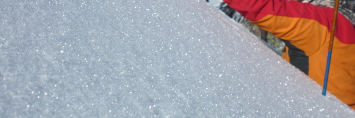
Overall the snowpack has settled and we are now in spring conditions.  The avalanche problems are due to solar radiation and rising temperatures throughout the day (Diurnal Fluctuations).  The way to manage these types of problems is to move from a sunny aspect to a shadier one throughout the day.

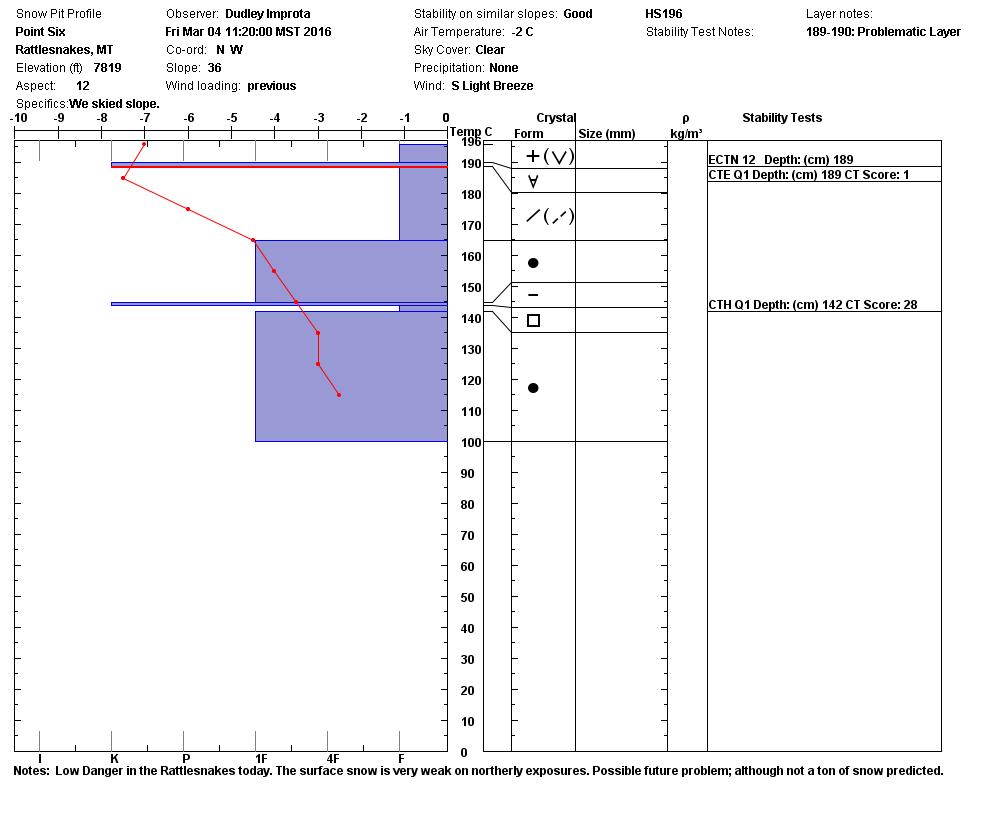
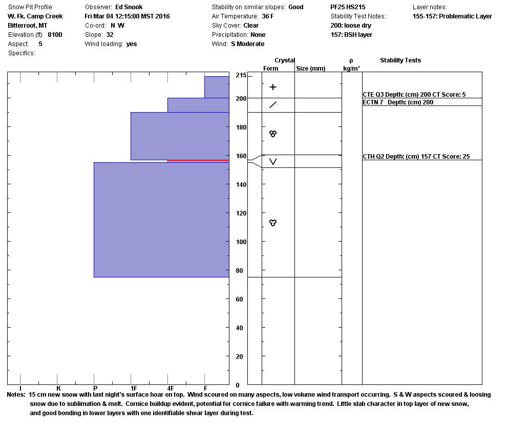
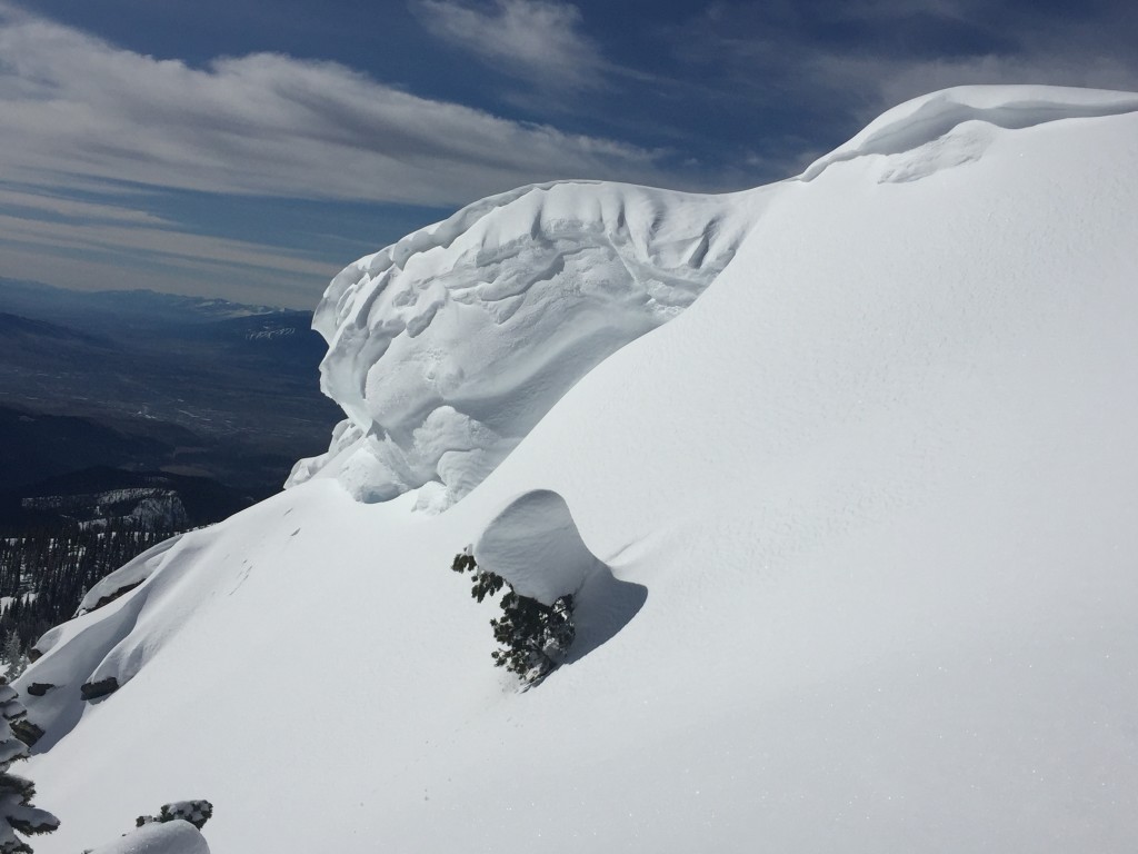
Dudley and I toured in the Rattlesnake yesterday.  The main avalanche problem we observed was loose wet avalanches in the afternoon on sun exposed slopes.  The second avalanche problem is cornice fall.  Ed was in the southern Bitterroot and made mention of the rising temperatures in the afternoon and how large the cornices are.  Cornices break father back than expected, give them space.  This video shows the layers we will be concerned with in the next storm cycle on Sunday.

Weather and Avalanche Outlook

There is a strong system predicted to enter the area early Sunday.  This system is predicted to bring strong winds and 2 to 5 inches of snow by Sunday evening.  The new load and strong winds will increase the avalanche danger.  The snow level will decrease rapidly Sunday afternoon.  The two problems to ask will be how the new snow bonds to the old snow surfaces(rime crust, surface hoar, and melt freeze crust). The second question will be are the facets reactive that are above the melt freeze crust from President’s Day weekend.

Ski and ride safe.  Logan will issue the next advisory on Tuesday.

READ FULL ADVISORY  

Problem 1 - Loose Wet

  • TYPE

    loose-wet

    Loose Wet

    Release of wet unconsolidated snow or slush. These avalanches typically occur within layers of wet snow near the surface of the snowpack, but they may quickly gouge into lower snowpack layers. Like Loose-Dry Avalanches,they start at a point and entrain snow as they move downhill, forming a fan-shaped avalanche. They generally move slowly, but can contain enough mass to cause significant damage to trees, cars or buildings. Other names for loose-wet avalanches include point-release avalanches or sluffs. Loose-wet avalanches can trigger slab avalanches that break into deeper snow layers.

  • SIZE

    2-3

    1 (Small)

    The potential size of avalanche resulting from this problem.

  • LIKELIHOOD

    Likelihood-3

    Possible

    The likelihood of an avalanche resulting from this problem.

  • ADDED DANGER

    Increased Slope Danger

    Increased/Added Danger

    There is an increased risk of avalanches on these slopes:

    E - East
    SE - Southeast
    S - South
    SW - Southwest
    W - West

Loose wet avalanches in the afternoon on sun exposed slopes.


Problem 2 - Cornice

  • TYPE

    cornices

    Cornices / Cornice Fall

    Release of an overhanging mass of snow that forms as the wind moves snow over a sharp terrain feature, such as a ridge, and deposits snow on the down-wind side. They range from small wind lips of soft snow to large overhangs of hard snow that are 30 feet (~10 meters) or taller. They can break off the terrain suddenly and pull back onto the ridge top and catch people by surprise even on the flat ground above the slope. Even small cornices can have enough mass to be destructive and deadly. Cornice fall can entrain loose surface snow or trigger slab avalanches.

  • SIZE

    3-4

    1-2 (Small-Large)

    The potential size of avalanche resulting from this problem.

  • LIKELIHOOD

    Likelihood-2

    Unlikely/Possible

    The likelihood of an avalanche resulting from this problem.

  • IMAGE

With warming temperature cornices are weakening.

VIDEO

State of the Snowpack

03/05/16 Gallery

FORECAST & OUTLOOK

There is a strong system predicted to enter the area early Sunday. This system is predicted to bring strong winds and 2 to 5 inches of snow by Sunday evening. The new load and strong winds will increase the avalanche danger.

This information is the sole responsibility of the Forest Service and does not apply to operating ski areas. The avalanche danger rating expires at midnight tonight but the information can help you make a more informed decision regarding travel in avalanche terrain for the next few days.

Our advisory area includes National Forest System lands in the Bitterroot Mountains from Lost Trail Pass north to Granite Pass, the Rattlesnake Mountains north of Missoula and the Southern Swan and Mission Mountains near Seeley Lake, MT. Avalanche information for the Lookout Pass/St. Regis Basin area is available from the Idaho Panhandle Avalanche Center.