Posted:
Mar 26, 2016 @ 6:46 am

The current avalanche danger is considerable in the west central Montana backcountry on steep(>35 degrees), wind loaded slopes above 7000 feet. Human triggered avalanches are likely on these slopes.  On all other slopes the danger is a stout moderate.  Today cautious decision making is essential and careful route finding is necessary.

Good morning, this is Travis Craft with the West Central Montana Avalanche Center’s avalanche advisory for March 26, 2016.  This danger rating does not apply to operating ski areas, expires at midnight tonight and is the sole responsibility of the U.S. Forest Service.

Weather and Snowpack

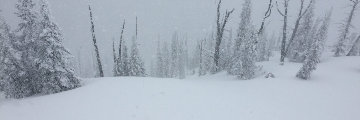
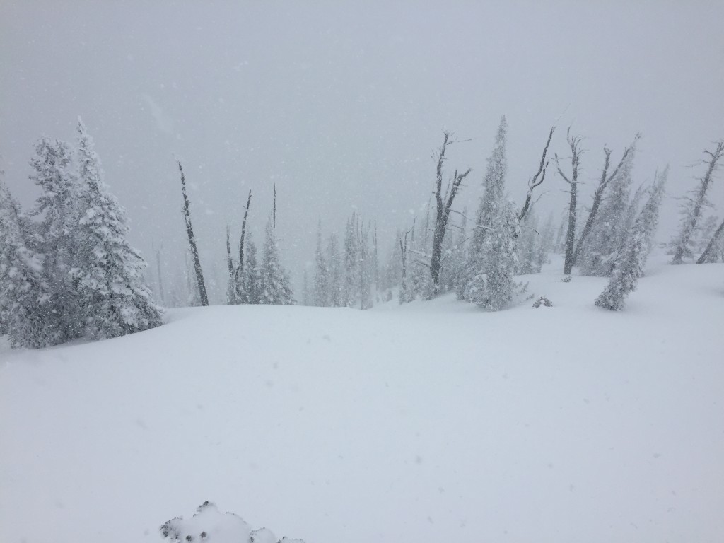
Mountain temperatures range from 14 F to 24 F in the region. Winds are 04 mph with gusts of 06 mph out of the SSW in the Bitterroot.  At Point Six in the northern part of the advisory area winds are 06 mph with gusts of 09 mph out of the WSW.  The forecast area received 10-18 inches in the last 48 hours.  The Twin Lakes Snotel in the central Bitterroot and North Fork Jocko in the northern portion of the advisory area picked up the most snow.

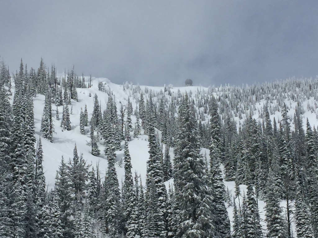
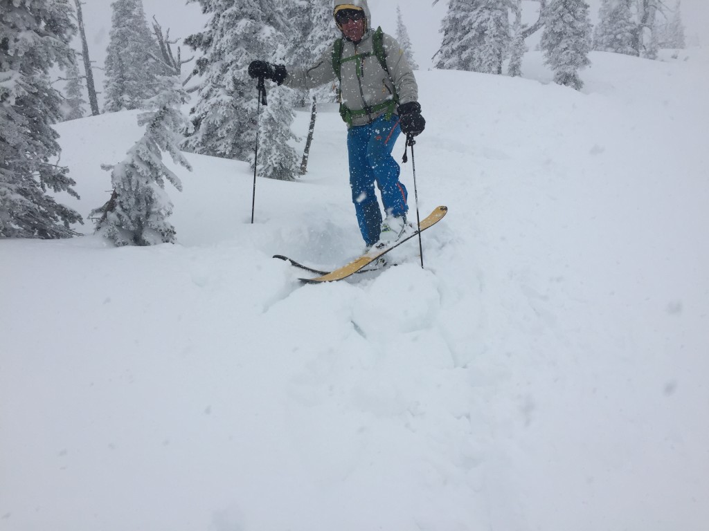
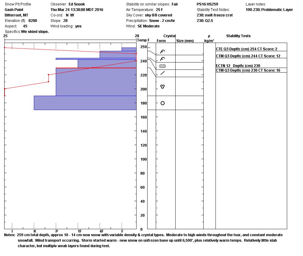
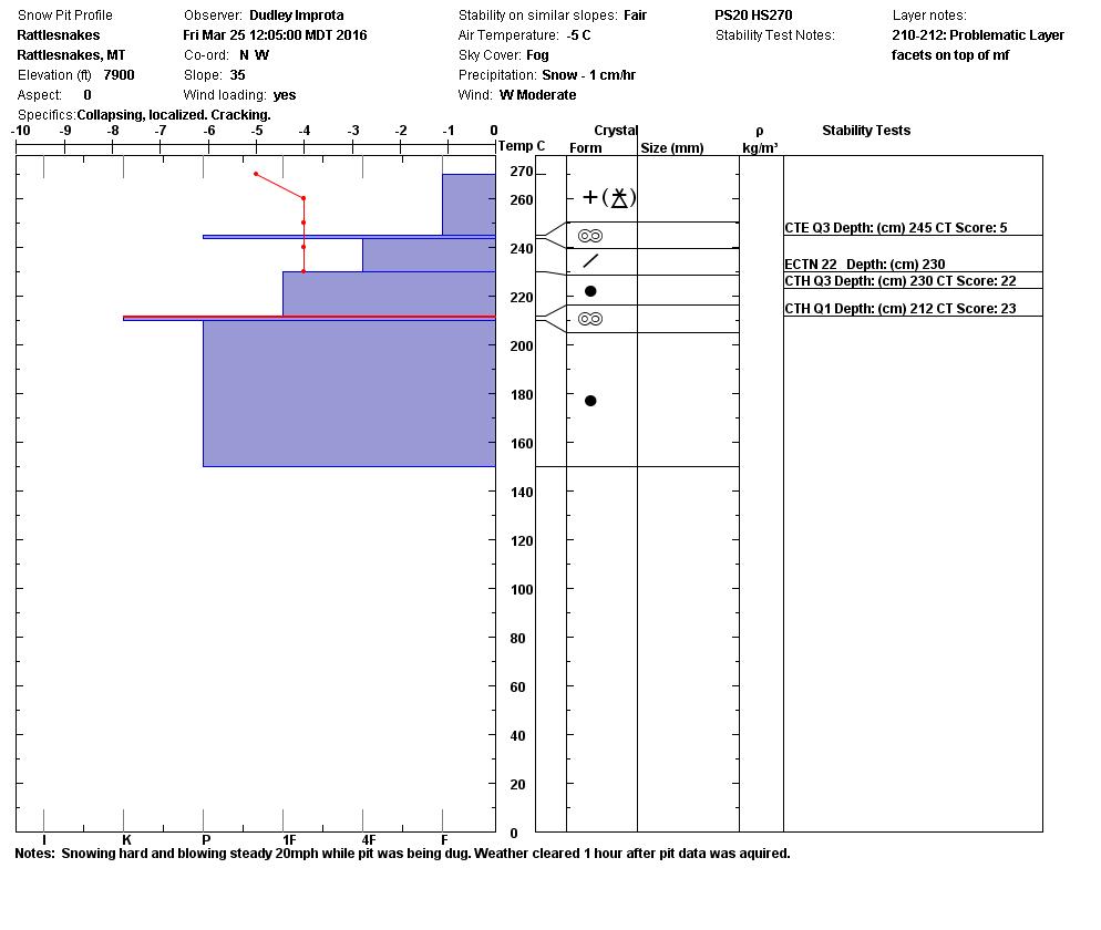
Dudley and I toured in the Rattlesnake yesterday.  Ed was at Gash Point on Thursday in the central Bitterroot.  Winter has made a strong comeback above 6500 feet.  The first avalanche problem are wind slabs.  In the last 48 hours we have had strong winds accompanying new snow,  this has created wind slabs on leeward terrain that are small to large in size depending on the snow totals in the area.  These slabs were touchy to Dudley and I in the Rattlesnake.

The Second avalanche problem are storm slabs.  These slabs are reactive to human triggers on steep slopes(>35 degrees).  The slab sits on top of the last melt freeze crust and ranges in depth from 10 inches to 16 inches throughout the advisory area.

The third avalanche problem are loose dry avalanches.  The new snow sits on the last melt freeze crust and has not bonded well to this crust.   Where the new snow has not consolidated into a slab you will likely trigger a large loose dry avalanche.  These sluffs were large yesterday in the Rattlesnake and at Gash point on Thursday.  These loose dry avalanches have the potential if you are not paying attention to knock you down and take you into a terrain trap on steep slopes(>35 degrees).

The last avalanche problem is cornice failure.  It is spring, the cornices are large and with the warm temperatures in the afternoon cornices are weakening.  Give cornices respect by limiting the time below them and give them a wide berth on ridges.  Cornices break farther back than expected.

The last two melt freeze crusts are the layers of concern in the snowpack.  They have not propagated in any of our tests in the last couple of weeks, but should be evaluated.  If I was recreating today, I would dig a pit a meter into the snow pack and see if any of these layers are reactive with the new loading.  I would look for signs of wind loading, scoured snow surface, hollow sounding snow and I would avoid aspects that showed any of these.  The storm slab will show itself by localized cracking and shooting cracks from the skis on your feet or machine.  The sluffs will be identified by loose unconsolidated snow triggered from your mode of travel in the backcountry.

Weather and Avalanche Outlook 

Through Sunday we will have a high pressure system throughout the region.  On Sunday a cold front is expected to push into the area and bring with it the ability to produce afternoon snow showers.  It should leave the area by Monday night.  These warmer conditions in our region will make it feel like spring in the high country until the cold front pushes in on Sunday.  The avalanche danger will stay the same, but change the problem of loose dry to loose wet in the afternoons on sun exposed slopes.

Ski and ride safe.  I will issue the next advisory on Tuesday.


READ FULL ADVISORY  

Problem 1 - Wind Slabs

  • TYPE

    wind-slabs

    Wind Slabs

    Release of a cohesive layer of snow (a slab) formed by the wind.  Wind typically erodes snow from the upwind sides of terrain features and deposits snow on the downwind side.  Wind slabs are often smooth and rounded and sometimes sound hollow, and can range from soft to hard. Wind slabs that form over a persistent weak layer (surface hoar, depth hoar, or near-surface facets) may be termed Persistent Slabs or may develop into Persistent Slabs.

  • SIZE

    3-4

    1-2 (Small-Large)

    The potential size of avalanche resulting from this problem.

  • LIKELIHOOD

    Likelihood-3

    Possible

    The likelihood of an avalanche resulting from this problem.

  • IMAGE

Wind slabs have formed on leeward terrain and are touchy.

Problem 2 - Strom Slab

  • TYPE

    storm-slabs

    Storm Slabs

    Release of a soft cohesive layer (a slab) of new snow which breaks within the storm snow or on the old snow surface. Storm-slab problems typically last between a few hours and few days. Storm-slabs that form over a persistent weak layer (surface hoar, depth hoar, or near-surface facets) may be termed Persistent Slabs or may develop into Persistent Slabs.

  • SIZE

    3-4

    1-2 (Small-Large)

    The potential size of avalanche resulting from this problem.

  • LIKELIHOOD

    Likelihood-4

    Possible/Likely

    The likelihood of an avalanche resulting from this problem.

The advisory area has received 10 to 16 inches of new snow in the last 48 hours.


Problem 3 - Loose Dry

  • TYPE

    loose-dry

    Loose Dry

    Release of wet unconsolidated snow or slush. These avalanches typically occur within layers of wet snow near the surface of the snowpack, but they may quickly gouge into lower snowpack layers. Like Loose-Dry Avalanches,they start at a point and entrain snow as they move downhill, forming a fan-shaped avalanche. They generally move slowly, but can contain enough mass to cause significant damage to trees, cars or buildings. Other names for loose-wet avalanches include point-release avalanches or sluffs. Loose-wet avalanches can trigger slab avalanches that break into deeper snow layers.

  • SIZE

    3-4

    1-2 (Small-Large)

    The potential size of avalanche resulting from this problem.

  • LIKELIHOOD

    Likelihood-6

    Likely/Very Likely

    The likelihood of an avalanche resulting from this problem.

On steep slopes >35 degrees you will be able to produce some very large loose dry avalanches.

Problem 4 - Cornices

  • TYPE

    cornices

    Cornices / Cornice Fall

    Release of an overhanging mass of snow that forms as the wind moves snow over a sharp terrain feature, such as a ridge, and deposits snow on the down-wind side. They range from small wind lips of soft snow to large overhangs of hard snow that are 30 feet (~10 meters) or taller. They can break off the terrain suddenly and pull back onto the ridge top and catch people by surprise even on the flat ground above the slope. Even small cornices can have enough mass to be destructive and deadly. Cornice fall can entrain loose surface snow or trigger slab avalanches.

  • SIZE

    5-6

    2-3 (Large)

    The potential size of avalanche resulting from this problem.

  • LIKELIHOOD

    Likelihood-1

    Unlikely

    The likelihood of an avalanche resulting from this problem.

Cornices are very large and it is springtime where they are the largest of the year and with the warmer temperatures will weaken in the afternoon.

VIDEO

State of the snowpack

03/26/2016 Advisory

FORECAST & OUTLOOK

Sun and high pressure today into Sunday.  Then afternoon snow on Sunday into Monday.

This information is the sole responsibility of the Forest Service and does not apply to operating ski areas. The avalanche danger rating expires at midnight tonight but the information can help you make a more informed decision regarding travel in avalanche terrain for the next few days.

Our advisory area includes National Forest System lands in the Bitterroot Mountains from Lost Trail Pass north to Granite Pass, the Rattlesnake Mountains north of Missoula and the Southern Swan and Mission Mountains near Seeley Lake, MT. Avalanche information for the Lookout Pass/St. Regis Basin area is available from the Idaho Panhandle Avalanche Center.