Posted:
Jan 12, 2017 @ 5:58 am

The current avalanche danger is MODERATE in the west central Montana backcountry.  Evaluate snow and terrain carefully; identify features of concern.  Human triggered avalanches are possible.

Good morning, this is Travis Craft with the West Central Montana Avalanche Center’s avalanche advisory for January 12, 2017.  This danger rating does not apply to operating ski areas, expires at midnight tonight and is the sole responsibility of the U.S. Forest Service.

Weather and Snowpack

Mountain temperatures range from -2 F to 16 F in the region.  Winds are calm in the Bitterroot.  Point Six, in the northern part of the advisory area, winds are reading 5 mph with gusts of 10 mph out of the W.  The forecast area received 0 to 3 inches of new snow in the last 24 hours.  The new snow had SWE’s ranging from 0 to .2 inches of water.

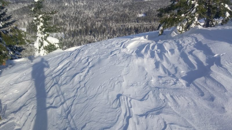
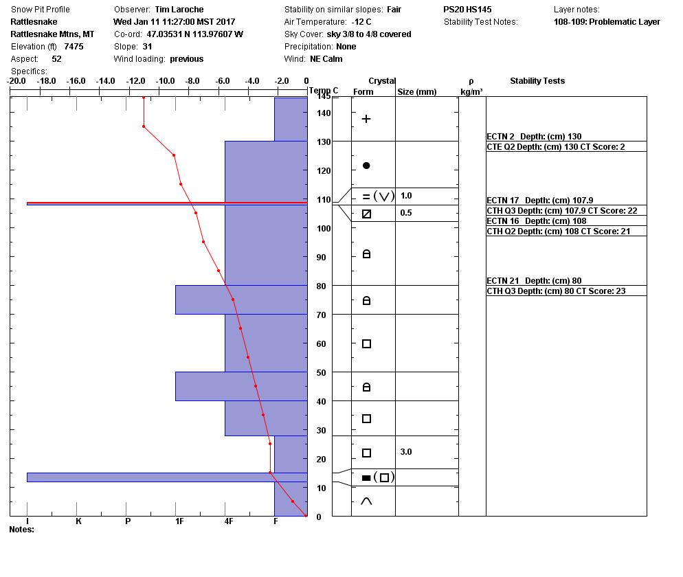
Tim and I toured in the Rattlesnake yesterday.  We experienced excellent visibility and decreasing instabilities in the snow pack.  John Lehrman, from Downing Mountain Lodge in the central Bitterroots, sent us observations finding the new snow is bonding well to the old snow surfaces.

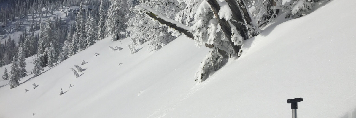
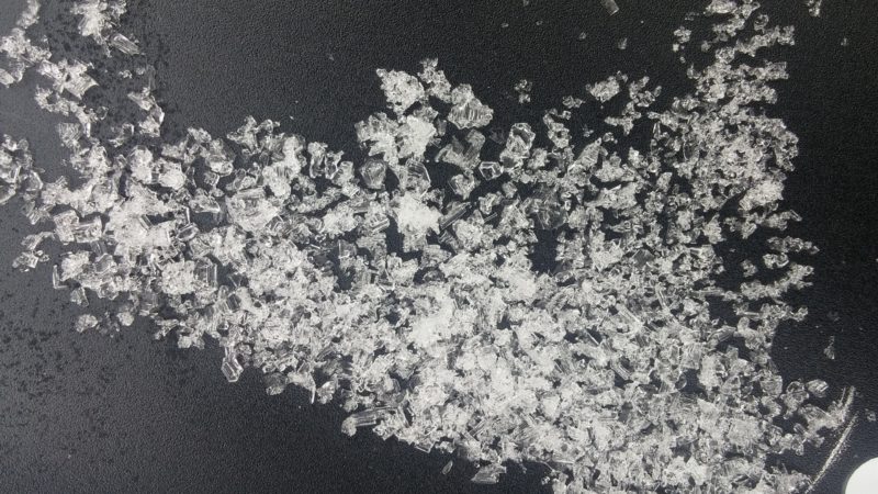
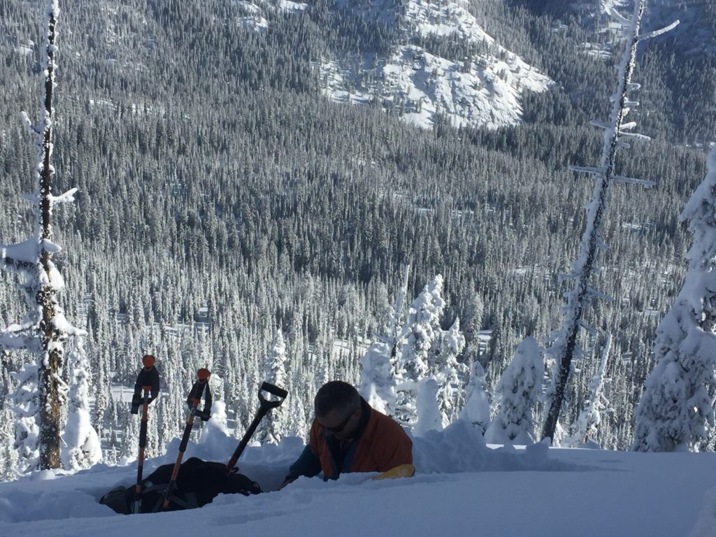
The first avalanche problem is persistent slabs.  There are two layers of concern that are on all aspects and elevations.  The first layer is near surface facets located below a crust 30 cm from the surface.  Tim and I were able to get this layer to propagate in only 1 of our ECT’s on a south slope.  The basal facets are the second layer of concern.  We were not able to get these to propagate in ECT’s, but they did fail in compression tests.  The only way to assess these layers is to dig a pit and see if these layers are reactive.

The second avalanche concern is wind slabs.  Our last storm consisted of dense snow accompanied with moderate winds.  The wind was able to produce small wind slabs on the north aspects of the compass.  These slabs are possible to trigger today.

Avalanche and Weather Outlook

We are entering a cold and dry period.  Expect an increase in sunshine towards the weekend.  Expect the danger rating to stay the same with the current forecast.

We are sponsoring a free weather lecture tonight at the University of Montana in the North Urey Underground Lecture Hall from 6:00 pm to 8:00 pm.  Check our education page for more information.

If you are out in the backcountry please send us your observations, these are very helpful in producing the advisory.

I will issue the next advisory on Saturday, January 14, 2017.

Ski and ride safe.


READ FULL ADVISORY  

Problem 1 - Persistent Slabs

  • TYPE

    persistent-slabs

    Persistent Slabs

    Release of a cohesive layer of soft to hard snow (a slab) in the middle to upper snowpack, when the bond to an underlying persistent weak layer breaks.  Persistent layers include: surface hoar, depth hoar, near-surface facets, or faceted snow. Persistent weak layers can continue to produce avalanches for days, weeks or even months, making them especially dangerous and tricky. As additional snow and wind events build a thicker slab on top of the persistent weak layer, this avalanche problem may develop into a Persistent, Deep-Slab.

  • SIZE

    3-4

    1-2 (Small-Large)

    The potential size of avalanche resulting from this problem.

  • LIKELIHOOD

    Likelihood-3

    Possible

    The likelihood of an avalanche resulting from this problem.

  • IMAGE

Two layers of concern:

1.  A Layer of near surface facets below a crust 30 cm from the surface.

2.  The basal facets on the ground.

Problem 2 - Wind Slabs

  • TYPE

    wind-slabs

    Wind Slabs

    Release of a cohesive layer of snow (a slab) formed by the wind.  Wind typically erodes snow from the upwind sides of terrain features and deposits snow on the downwind side.  Wind slabs are often smooth and rounded and sometimes sound hollow, and can range from soft to hard. Wind slabs that form over a persistent weak layer (surface hoar, depth hoar, or near-surface facets) may be termed Persistent Slabs or may develop into Persistent Slabs.

  • SIZE

    3-4

    1-2 (Small-Large)

    The potential size of avalanche resulting from this problem.

  • LIKELIHOOD

    Likelihood-3

    Possible

    The likelihood of an avalanche resulting from this problem.

  • ADDED DANGER

    Increased Slope Danger

    Increased/Added Danger

    There is an increased risk of avalanches on these slopes:

    N - North
    NE - Northeast
    NW - Northwest

  • IMAGE

There are wind slabs on leeward terrain.

VIDEO

Observations 01/11/2016

FORECAST & OUTLOOK

We are entering a period of sunny weather and colder temperatures.

This information is the sole responsibility of the Forest Service and does not apply to operating ski areas. The avalanche danger rating expires at midnight tonight but the information can help you make a more informed decision regarding travel in avalanche terrain for the next few days.

Our advisory area includes National Forest System lands in the Bitterroot Mountains from Lost Trail Pass north to Granite Pass, the Rattlesnake Mountains north of Missoula and the Southern Swan and Mission Mountains near Seeley Lake, MT. Avalanche information for the Lookout Pass/St. Regis Basin area is available from the Idaho Panhandle Avalanche Center.