Professional Observation
Basic Information
Observation Details
Observation Date:
December 22, 2021Submitted:
December 22, 2021Observer:
WCMAC - Jeff CartyZone or Region:
RattlesnakeLocation:
Around Point 6Signs of Unstable Snow
Recent Avalanches?
YesCracking?
IsolatedCollapsing?
None ExperiencedSnow Stability
Stability Rating:
GoodConfidence in Rating:
ModerateStability Trend:
WorseningMedia
Advanced Information
Weather Summary
Cloud Cover:
Mostly CloudyTemperature:
25º F (-4ºC)Wind:
Light , SW
Mild wind all day, no snow transport observed.
No precipitation during the day.
Avalanche Observations
| # | Date | Location | Size | Type | Bed Sfc | Depth | Trigger | Comments | Photo |
|---|---|---|---|---|---|---|---|---|---|
| 1 | Today |
Jenny Bowl E 7800' |
D1 | HS | I-New/Old Interface | 6" |
N-Natural u-Unintentional |
This was a very small slide caused by a falling tree. It shows there are still small pockets of reactive wind slab. |
|
Snowpack Observations
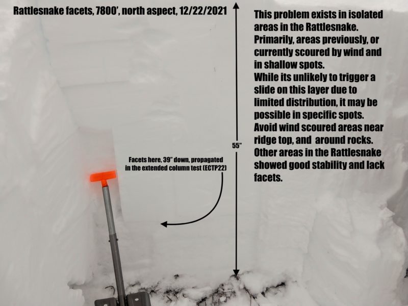
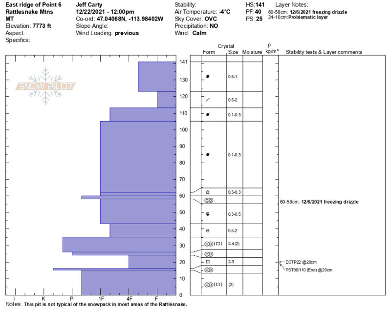
We got surprised by reactive basal facets under 150cm of snow. This is in contrast to the well-rounded snowpack found elsewhere in the forecast area. The pit was dug near the ridgeline at 7800 feet, in an exposed location. Past scouring and consistent winds likely contributed to facet development. We had an extended column test propagate on the 22 taps 39 inches down (ECTP22 down 100cm). The block slide with force into the pit. However, these reactive facets seem to be isolated to exposed ridges and shaded aspects. A propagation saw test (PST) done adjacent to this pit showed low propagation likelihood, and an ECT 200 feet downslope had no failure. It is good to note that facets exist in isolated areas in the Rattlesnake. Throughout our tour, we found shallow spots around buried rocks where facets have grown. Triggering a slide in this layer is unlikely due to limited distribution, but a slight possibility exists. It is best to avoid these areas as you tour in the Rattlesnake. Most aspects had wind buffed snow, and the snowpack has stiffened up considerably from two days ago.
The freezing level was around 6000 feet, with snow getting progressively heavier below this.