Professional Observation
Basic Information
Observation Details
Observation Date:
January 5, 2022Submitted:
January 5, 2022Observer:
WCMAC - David FoxZone or Region:
Central BitterrootsLocation:
Ward MountainSigns of Unstable Snow
Recent Avalanches?
None ObservedCracking?
None ExperiencedCollapsing?
None ExperiencedBottom Line
Wind Slabs- Westerly ridgetop winds were easily transporting new low density snow in open exposed terrain loading N/NE aspects.
Loose snow- 14" of F density unconsolidated snow on top of a rounding BSH layer.
There is a hollow, faceted snowpack on North aspects below 6500'
No obvious signs of instability while touring between 4300-8200' on East and North aspects.
Advanced Information
Weather Summary
Cloud Cover:
OvercastTemperature:
15F (-9C)Wind:
Light , WTemperatures ranged from 25F (-4C) in the lower elevation to 15F (-9C) at 8,000'. Light snowfall lasted until mid afternoon producing 2" (5cm) of new snow today. Above 7,000' winds were W at 5 mph with occasional gusts to 15mph. Observed wind transport of new low density snow in open exposed terrain along ridgelines.
Snowpack Observations
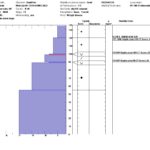
Height of snowpack at 8,000' was 135cm. 35cm of new snow. Pit was located on a NE aspect (45 degrees) with a 24 degree slope.
CT1, ECTN 4 @ 120cm. New snow interface.
CT23 @ 100cm RP. Failed on a rounding BSH layer from last weekends cold temps.
CT26 @ 90cm RP. Failed on a rounding, older BSH layer.
New Snow past 48 Hours
8-10" (20-25cm) between 4,300'-6,000'
10-14" (25-35cm) 6.000'-8,200'