Professional Observation
Basic Information
Observation Details
Observation Date:
January 23, 2022Submitted:
January 24, 2022Observer:
WCMAC - George D'AngeloZone or Region:
Southern BitterrootsLocation:
West Fk Camp Cr.Signs of Unstable Snow
Recent Avalanches?
None ObservedCracking?
IsolatedCollapsing?
None ExperiencedSnow Stability
Stability Rating:
GoodConfidence in Rating:
HighStability Trend:
SteadyBottom Line
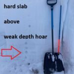
Generally a rightside up snowpack. Small windslabs at upper elevations were the primary problem today. Moderate west winds were actively transporting snow. A 3.5-4.5 ft deep slab problem persists in the middle and upper elevations on NW-E aspects with tests showing the weak depth hoar near the ground slow to gain strength. Triggering this deeply buried weak layer in a shallow and/or rocky area could result in a very large and destructive avalanche. Widespread surface hoar development on most aspects with strong solar radiation affecting surfaces of S-SW aspects.
Advanced Information
Weather Summary
Cloud Cover:
Mostly SunnyTemperature:
30*FWind:
Moderate , WIt was the warmest day so far after the last storm. Plenty of snow was being transported today at ridgelines in the middle and upper elevations
Snowpack Observations
We were getting some Resistant Planar fractures on 3mm buried surface hoar about 25cm down in our compression tests on a N aspect. PST 55/140 end on rounding depth hoar.
Avalanche Problems
| Problem | Location | Distribution | Sensitivity | Size | Comments |
|---|---|---|---|---|---|
 Wind Slab
|
|
Terrain Use
We skied soft, low angle terrain
Close