Professional Observation
Basic Information
Observation Details
Observation Date:
February 2, 2022 - February 2, 2022Submitted:
February 2, 2022Observer:
WCMAC - Todd GlewZone or Region:
RattlesnakeLocation:
Lockwood PointSigns of Unstable Snow
Recent Avalanches?
None ObservedCracking?
None ExperiencedCollapsing?
None ExperiencedSnow Stability
Stability Rating:
GoodConfidence in Rating:
ModerateStability Trend:
WorseningBottom Line
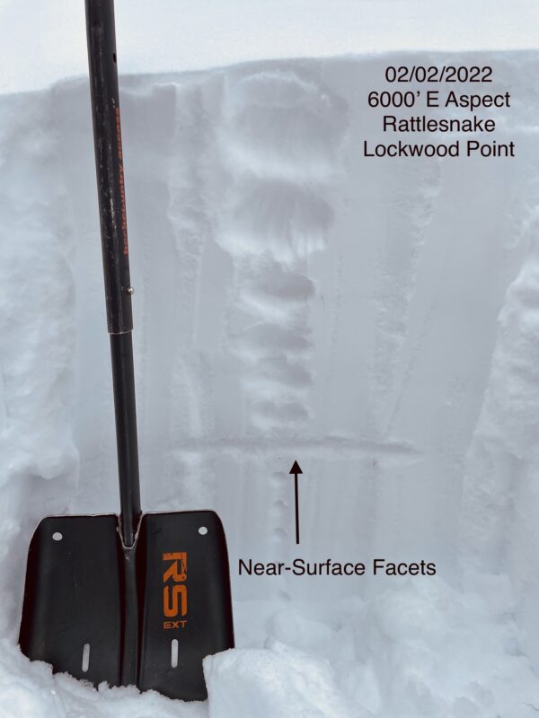
Travel was from 3500' to 6600.' We toured up a low-angle ridge to the top of Lockwood Point. Above 5500', we found about 12" (30cm) of low-density snow had fallen since the beginning of the week. Above 5500' in wind-protected non-solar aspects, we found near-surface facets buried below the new snow. The new snow sitting on top of near-surface facets was not propagating in ECT's. There was no propagation because the new snow had not yet formed a slab, creating propagation propensity. I expect increased avalanche hazard and propagation in ECT's with more snow and wind in the forecast.
Media
Advanced Information
Weather Summary
Cloud Cover:
OvercastTemperature:
-9°F to 5°F (-23°C to -15°C)Wind:
LightVery cold day in the mountains. Very light ridge top winds.
Close