Professional Observation
Basic Information
Observation Details
Observation Date:
February 2, 2022Submitted:
February 2, 2022Observer:
WCMAC - Trask BaughmanZone or Region:
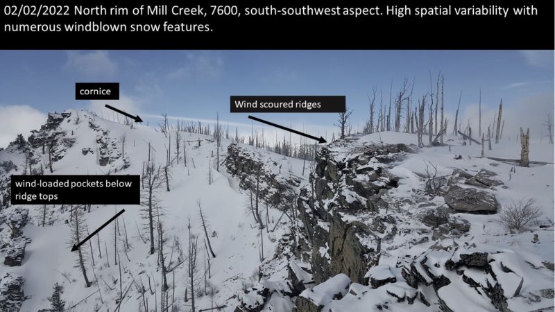
Central BitterrootsLocation:
North Rim of Mill CreekSigns of Unstable Snow
Recent Avalanches?
None ObservedCracking?
None ExperiencedCollapsing?
None ExperiencedSnow Stability
Stability Rating:
FairConfidence in Rating:
LowStability Trend:
WorseningBottom Line
Today we toured from 4000ft to 7600ft on the north rim of Mill Creek. We found widespread poor structure in the snowpack, a breakable crust with weak surgery snow (facets .5mm), 12 inches down (30cm). We observed high spatial variability in the new surface snow throughout the tour. We saw ice crust, deep pillows of snow up to 20inches (50cm), fresh wind lips, hollow-sounding wind-loaded pockets below ridge tops. We did not observe any red flags like shooting cracks, but we had high uncertainty in our observation due to the variability and overall poor structure, so we stuck to slopes less than 30°.
Media
Advanced Information
Weather Summary
Cloud Cover:
Mostly SunnyTemperature:
3°f to 9°fWind:
StrongAbove 6000 ft, we observed strong spiraling gusts of winds forming windblown snow features on all aspects. Winds picked up as the day progressed. By 3 pm, snow transport could be observed from the valley on the significant highpoints in the central Bitterroot.
Close