Professional Observation
Basic Information
Observation Details
Observation Date:
February 20, 2022 - February 20, 2022Submitted:
February 23, 2022Observer:
WCMAC - Jane QuinnZone or Region:
Central BitterrootsLocation:
Mt. Fuji, Lolo PassSigns of Unstable Snow
Recent Avalanches?
None ObservedCracking?
None ExperiencedCollapsing?
None ExperiencedSnow Stability
Stability Rating:
FairConfidence in Rating:
ModerateStability Trend:
ImprovingBottom Line
Our January 9th persistent weak layer appears to be healing, but we were able to get fracture initiation and propagation on NW and S aspects. It is still worth investigating and performing and extended column test before committing to slopes with consequential features like cliff bands and steep gullies.
Advanced Information
Weather Summary
Cloud Cover:
OvercastTemperature:
32 FWind:
Light , SWWinds were not as strong as forecasted, and temperatures did not get above freezing as predicted. Precipitation varied from none to moderate.
Snowpack Observations
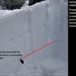
CT 24 SP down 65 cm on 3-4mm rounding facets
ECTP 22 on same layer on south aspect at 5740 elevation
ECTN 22 on same layer on northwest aspect
RB 5 on same layer on northwest aspect

Avalanche Problems
Persistent weak layer from January 9th ranging between 55 to 65 cm (26") in depth.
Terrain Use
Our mindset was status quo due to the uncertainty regarding the sensitivity of the weak layer. We stuck to 30 degree slope angles in light of this.
Close