Professional Observation
Basic Information
Observation Details
Observation Date:
February 23, 2022Submitted:
February 23, 2022Observer:
WCMAC - David FoxZone or Region:
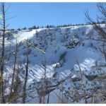
Central BitterrootsLocation:
Ward MountainSigns of Unstable Snow
Recent Avalanches?
None ObservedCracking?
None ExperiencedCollapsing?
None ExperiencedSnow Stability
Stability Rating:
GoodConfidence in Rating:
HighStability Trend:
SteadyBottom Line
Covered E, N and S aspects between 4300'-8300'
Stable conditions with no signs of instability observed.
Cold, low density snow sitting on firm base could produce sluffing in steep terrain.
Signs of previous wind impacts in the mid elevations (5500-7000'). Potential for loading on NE aspects.
Widespread, large surface hoar present on south aspects. None observed on other aspects.
Advanced Information
Weather Summary
Cloud Cover:
ClearTemperature:
8F (-13C)Wind:
Calm , NClear, sunny day. Cold temperatures ranging between 0 to 12F (-17 to -11C). Winds were calm with a light (1-3MPH) North breeze in the late afternoon. No snow transport observed but plenty available.
Snowpack Observations
Height of Snowpack at 7500' was 155cm. Pit was located on a NE aspect (45 degrees) with a 27 degree slope.
Observed weak layer was the new snow interface. Snow appears to be bonding well to old crusts and firm snow.
CT 20 @ 20cm (Broken). Approximately 8" (20cm) of new low density snow (F) on top of a 1" (3CM) layer of old wind affected snow 4f+.
ECTN13 @ 20CM.