Professional Observation
Basic Information
Observation Details
Observation Date:
March 9, 2022Submitted:
March 9, 2022Observer:
WCMAC - Geoff FastZone or Region:
Southern BitterrootsLocation:
Lost Trail BackcountrySigns of Unstable Snow
Recent Avalanches?
YesCracking?
IsolatedCollapsing?
None ExperiencedSnow Stability
Stability Rating:
FairConfidence in Rating:
HighStability Trend:
WorseningBottom Line
Signs of instability on firm ice interface/rain crust directly below new 20-30cms (8-10inches) of new snow. As soft snow consolidates and hardens, watch for fractures on all aspects on slopes above 30 degrees, down to this firm ice layer.
Wind slabs are widespread and touchy near ridgelines.
Media

Advanced Information
Weather Summary
Cloud Cover:
Mostly SunnyTemperature:
-16C / 3F 1030am to -12C / 10F by 1pmWind:
Light , SCold (-16C / 3F) and mostly clear, with slight breeze from south. Temps did rise to -12C / 10F by 1pm. Snow arrived throughout the previous day, and then cleared overnight bringing frigid temps (-22C / -8F). There was light to moderate south wind during the storm, and wind slabs on northern leeward slopes are touchy.
Avalanche Observations
| # | Date | Location | Size | Type | Bed Sfc | Depth | Trigger | Comments | Photo |
|---|---|---|---|---|---|---|---|---|---|
| 1 | Past 24 hours |
West Fork Camp Creek; Lost Trail Backcountry E 7500 |
D1 | I-New/Old Interface | 20cms | N-Natural | Point Releases started this small slide. |
|
|
| 2 | Past 24 hours |
SE Shoulder of Saddle Mountain (proper); Lost Trail Backcountry E 7600 |
D1 | I-New/Old Interface | 20cms | N-Natural |
|
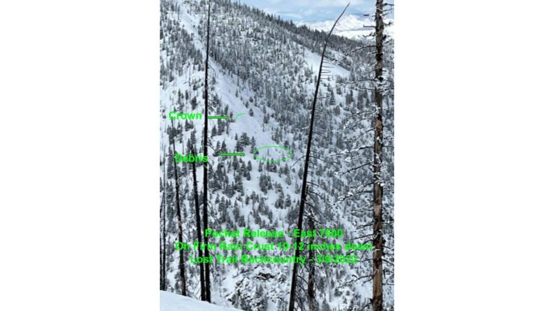
Two small pockets on easterly 38 degree slopes around 7500' fractured and slid on hard ice layer. Perhaps these easterly locations where new snow is most consolidated into storm slab is where they released. Watch out throughout the area as this slab consolidates.
Snowpack Observations
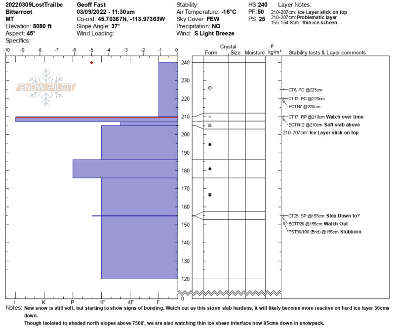
20-30 cms (8-12 inches) of new snow in Lost Trail Pass backcountry. This soft snow is sitting on a firm ice layer (rain crust) that is slick on top. Snow is starting to crack where is is consolidating into a storm slab - so far mainly on leeward sides of ridges and steeper slopes over 30 degrees. We anticipate this worsening over the next couple of days as the soft snow solidifies into stronger storm slab, making it likely for human triggered avalanches on slopes over 30 degrees. In 95" (240cm) deep snowpack, we noted CT17 RP down , and ECTN 12 down 12" (30cm) , on this layer. - Another concern that is isolated to steeper shaded north aspects is buried 85 cms down in snowpack. We are still getting reactions on this layer, though somewhat stubborn to react. In 95" (240cm) deep snowpack, we noted CT25, 33" (85cm) down, ECTP 25, and PST 90/100 End 33" (85cm) down.
.
Wind slabs are touchy