Professional Observation
Basic Information
Observation Details
Observation Date:
March 16, 2022Submitted:
March 16, 2022Observer:
WCMAC - David FoxZone or Region:
Central BitterrootsLocation:
CamasSigns of Unstable Snow
Recent Avalanches?
None ObservedCracking?
IsolatedCollapsing?
IsolatedSnow Stability
Stability Rating:
FairConfidence in Rating:
ModerateStability Trend:
SteadyBottom Line
Reactive Persistent Weak Layer- Isolated to steep terrain over 35 degrees, between 6,500'- 8,000'. Facets on top of the March 1 rain crust were causing settlements and resulted in propagation during stability tests (ECTP16). Approximately 21" (55cm) of snow on top of this layer has the potential to result in a large slab avalanche if triggered.
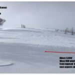
Isolated pockets of wind-loaded terrain on east aspects above 8,000'. Exposed north aspects were wind affected. Some small cracking and settlement were observed in these areas.
Advanced Information
Weather Summary
Cloud Cover:
Mostly CloudyTemperature:
22F (-5C)Wind:
Moderate , WVariable conditions with a mix of snow and clouds as well as periods of clear skies and sunshine. Temperatures ranged from 22-36F (-5 to 2C). Below 6000' was above freezing this afternoon. Winds were clam in the lower elevations but moderate above 8,000' ranging between 10-15 from the W/NW. Some past and active snow transport in exposed high elevation terrain.
Snowpack Observations
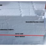
The height of Snowpack at 7700' was 290cm. Pit was located on an E aspect (110 degrees) with a 35-degree slope.
Isolated settling on steep terrain between 7,000-8,000'. Isolated pockets of wind loading on E aspects in exposed terrain above 8,000'.
Observed persistent weak layer is 5 CM of facets on the top of the March 1 rain crust located 55cm below the snow surface. Approximately 30CM of incohesive low-density snow (F) and 25CM of consolidated (4F+) snow sit on top of the weak layer.
ECTP16 @ 55CM.