We’re in the midst of a spring teaser, and while many of you may be taking a quick stretch break and giving the knees a needed rest after charging transitional snow. I’ll give a brief season recap to provide some insight into what the remaining snowpack has to offer.
Driving back to Missoula after a day of collecting observations in the Seeley-swan area on Friday, February 11th, it was a little surprising to see that the entire south and east aspects of Mount Jumbo had melted and turned brown. It’s easy to think that our snowpack has failed to reach normal levels this year. While skiing and riding conditions may be far from stellar, we’re not off track by much looking at figures from the Natural Resources Conservation Service (NRCS).
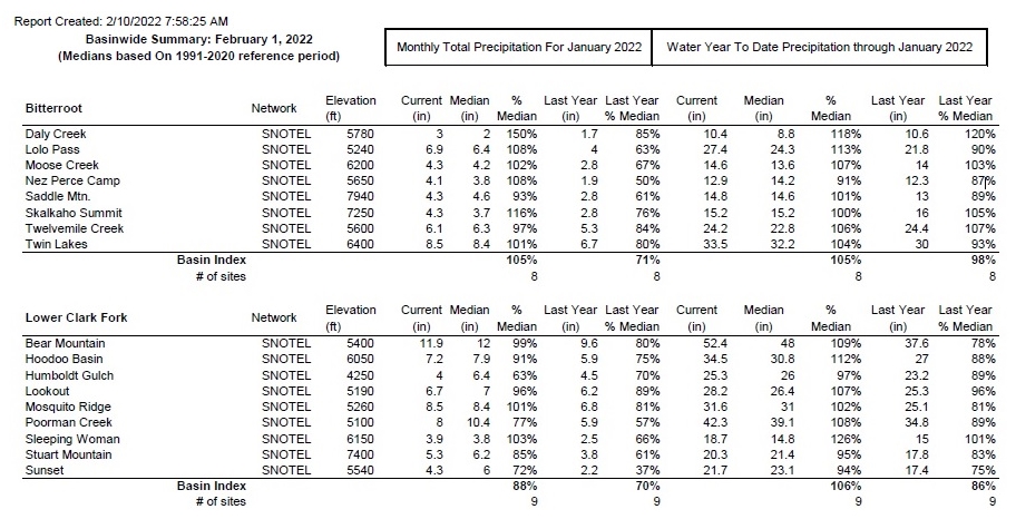
Above is a quick chart from the Natural Resources Conservation Service (NRCS) with snow water (SWE) totals for the Bitterroot and Lower Clark Fork river basins this year. The Upper Clark Fork drainage is 89% for median snow water equivalent through February 1st. Below is a map of snow water totals for the nearby river drainages.

Snowpack Summary
Small storms arrived on October 12th and 27th, followed by a significant warming event October 28th through November 7th. By the end of November, the snow height in the Bitterroot reached 11 inches at the Twin Lakes Snotel at 6400 feet, 19 inches at the Stuart Snotel at 7400 feet, and 9 inches at Lolo Pass Snotel at 5300 feet.
December started warm and dry. December 5th would see a storm of approximately 10 inches of snowfall and December 9th another 15 inches. Strong southwesterly wind and low-density snow prompted the West Central Montana Avalanche Center to issue its first forecast on December 11th. By the 13th, the snow height reached approximately 40 inches.
Seasonally cold temperatures arrived, and storms continued to stack up. December 17th brought an active storm pattern through the 21st. There was a brief pause in precipitation on December 22nd, causing a crust/facet layer followed by active arctic air-induced light snowfall through Christmas. The 26th and 27th had snow banding with broken skies, then December 28th brought low-density snow as an arctic air mass moved from the north. It remained cold in late December and early January with lots of unconsolidated snow.
We had a storm pulse cold on January 6th, then an atmospheric river entered our area on January 7th, prompting a high danger rating and avalanche warning. After a high-pressure warm-up, the northern reach of the forecast area was brushed by a pineapple express with a lot of southwest wind. The Mission Range picked up 1.4 inches of water on January 12th and 13th with freezing levels as high as 7,000 feet (North Fork Jocko Snotel). A few wet, loose slides and glide cracks were observed.

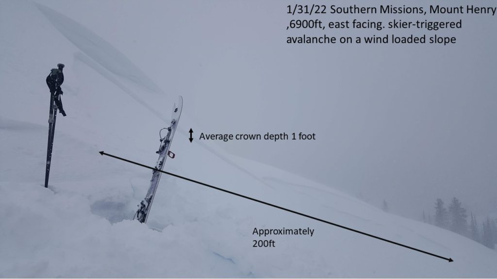
Snowfall returned in late January and lasted into early February. January 31st saw touchy wind slabs in the Seeley Swan range, but the lack of cohesion and slab formation allowed generally stable conditions to persist through the first week in February. Observations reported 2 feet of new snow from the prior week at 8500 feet in the Central Bitterroot on February 5th.
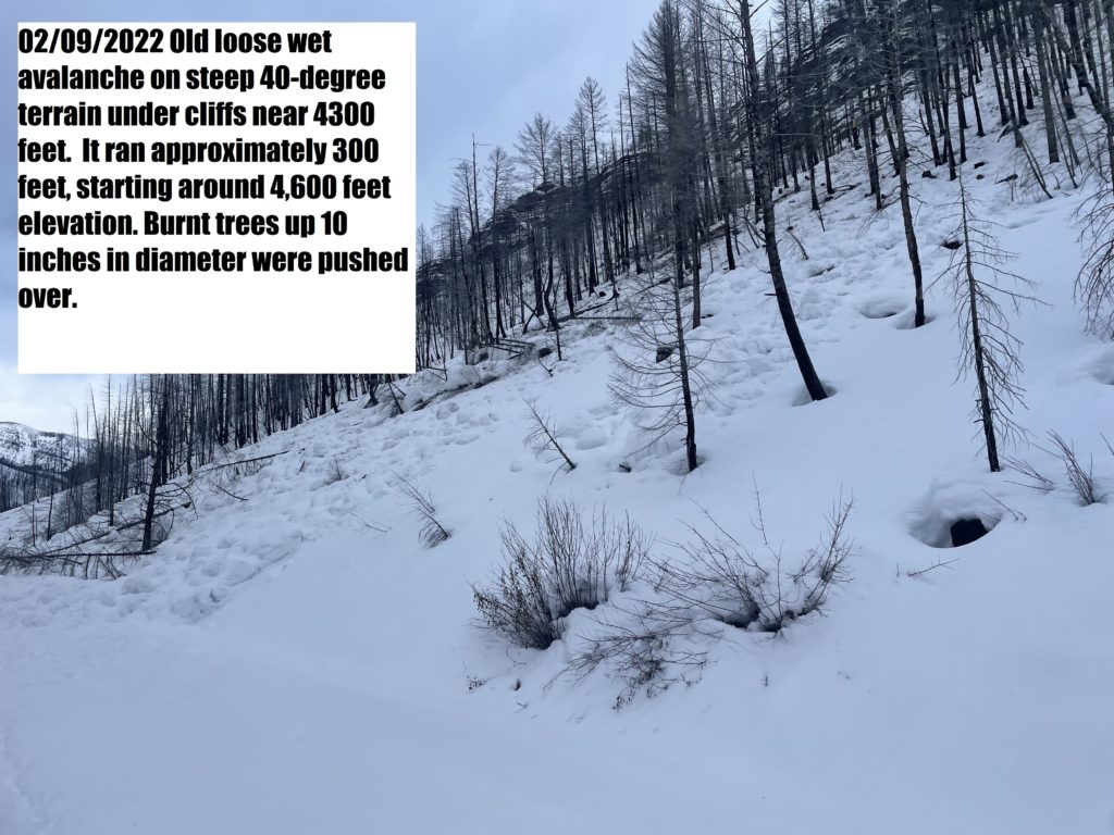
Earlier last week (February 6th to now February 16th), we had high pressure and sustained strong west and southwest winds. Temperatures began to climb on February 9th and started above freezing through the 10th, reaching a high of 37°F at the Stuart Mountain Snotel at 7,400 feet. We observed a few large loose wet slides, more likely occurring throughout the area.
Since then, diurnal temperature swings have set in, and our forecast message is similar to springtime messaging. Corn skiing may begin to ripen on solar aspects. With the low sun angle of February, timing may be more of a challenge than in April. Jeff wrote, “timing is everything, leave the descent too late, and you could be dealing with loose wet avalanches. Too early, and you could be dealing with dangerously icy conditions” in our most recent forecast. When planning your day, I suggest exploring Caltop’s sun angle shading mapping tool (in the righthand toolbox).
Outlook
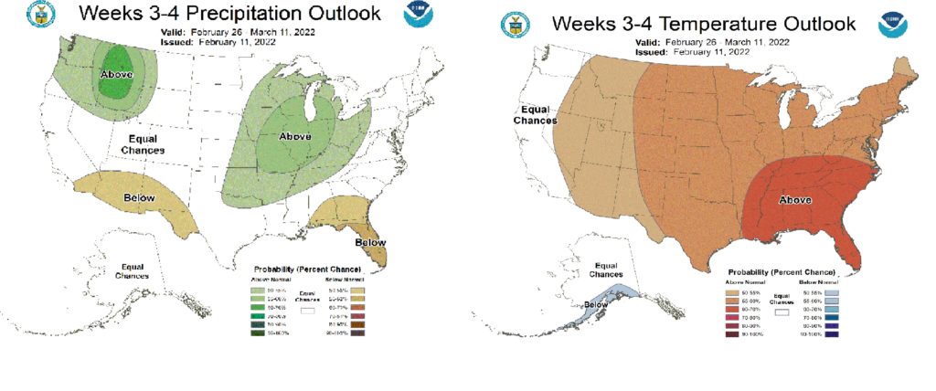
Dry and warm high pressure will continue through Valentine’s Day. A small wave of northerly flow will arrive on Tuesday and Wednesday (February 15-16th) this week and another wave next weekend (February 19-20th). Recent models from the Climate Prediction Center look wet and warm. They discuss sea surface temperature (SST) anomalies that remain negative, consistent with continuing La Nina condition. However, with “the emerging Madden-Julian Oscillation (MJO) over the Indian Ocean, there has been little eastward propagation in the recent days.” “Several models indicate that the signal is likely to propagate toward the Maritime Continent, which could interfere with the positive phase of the Arctic Oscillation (AO), which is expected to remain positive through at least the start of the forecast period.” In other words, many interactions of oscillating ocean currents across the globe lead to some uncertainty in the temperature forecasts over the western United States. However, continued La Nina conditions will likely correlate with normal to high precipitation rates for the Missoula area in the coming weeks.
Ski and ride safe.


