By WCMAC Intern Katie Matthews.
How would we summarize the start of our winter season here in West Central Montana? Three words: warm, dry, and thin.
Weather Summary
High pressure and infrequent snow storms dictated early-season weather patterns. We saw a lot of clear skies and above-average temperatures for this time of year. Unfortunately, these conditions continue to prolong eager backcountry users’ hopes of recreating in the snow.
Storms have been few and far between. The first three significant storms of the season (November 6th-8th, November 19th-20th, and December 1st-4th) were warm atmospheric rivers that deposited snow at upper elevations with high rain/snow lines. Snow from these storms forms the base of our snowpack and is a mix of melt-freeze crusts and depth hoar. The only avalanche cycle we have seen thus far was during and immediately following the December 1st-4th storm. These avalanches were on upper elevation north and east aspects. The last significant storm on Dec 10th-11th was colder and brought up to 18 inches of snow to the region.
Bitterroot precipitation, wind, and temperature summary from October and November of 2023. (skipig.org)
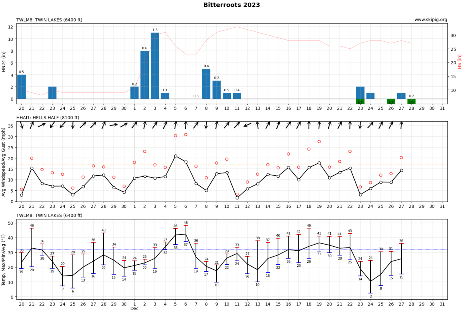
Bitterroot precipitation, wind, and temperature summary from December of 2023. (skipig.org)
Snowpack Summary
Our snowpack remains very thin due to below-average precipitation and above-average temperatures. Upper elevations hold a shallow snowpack, while lower elevations have little to no snow. As of January 2nd, most SNOTEL sites show SWE (snow water equivalent) amounts between 40-50% of their 20-year medians, putting them near or at historic lows.
Weak, faceted snow is the primary characteristic of our shallow snowpack. This is largely due to many cold, clear nights that created strong temperature gradients in the snowpack. Weak snowpack structure is especially distinct on north and east aspects that see less solar effect. These aspects have preserved more November snowfall, so they have more snow that has weakened into faceted, sugary snow.
The first several forecasts of the WCMAC season indicated low avalanche danger. However, forecasters note that a persistent slab problem still exists. In isolated areas, a slab of snow sits on old, weaker snow at the ground. The likelihood of triggering an avalanche is low and continues to decrease as the slab slowly facets. However, if triggered, an avalanche could be of high consequence with early season conditions. Forecasters also noted that red flags such as cracking, collapsing, or whumpfing may not be obvious. They advised digging down into the snow before committing to steep terrain and avoiding steep slopes if any unstable conditions are observed.
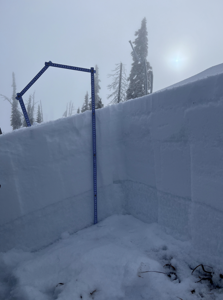
WCMAC forecaster snow pit from late December. Dug on a N aspect around 8,000ft in the Bitterroots. The bottom 25-30cm depicts the weak basal facets that have developed from preserved November snow. (missoulaavalanche.org)
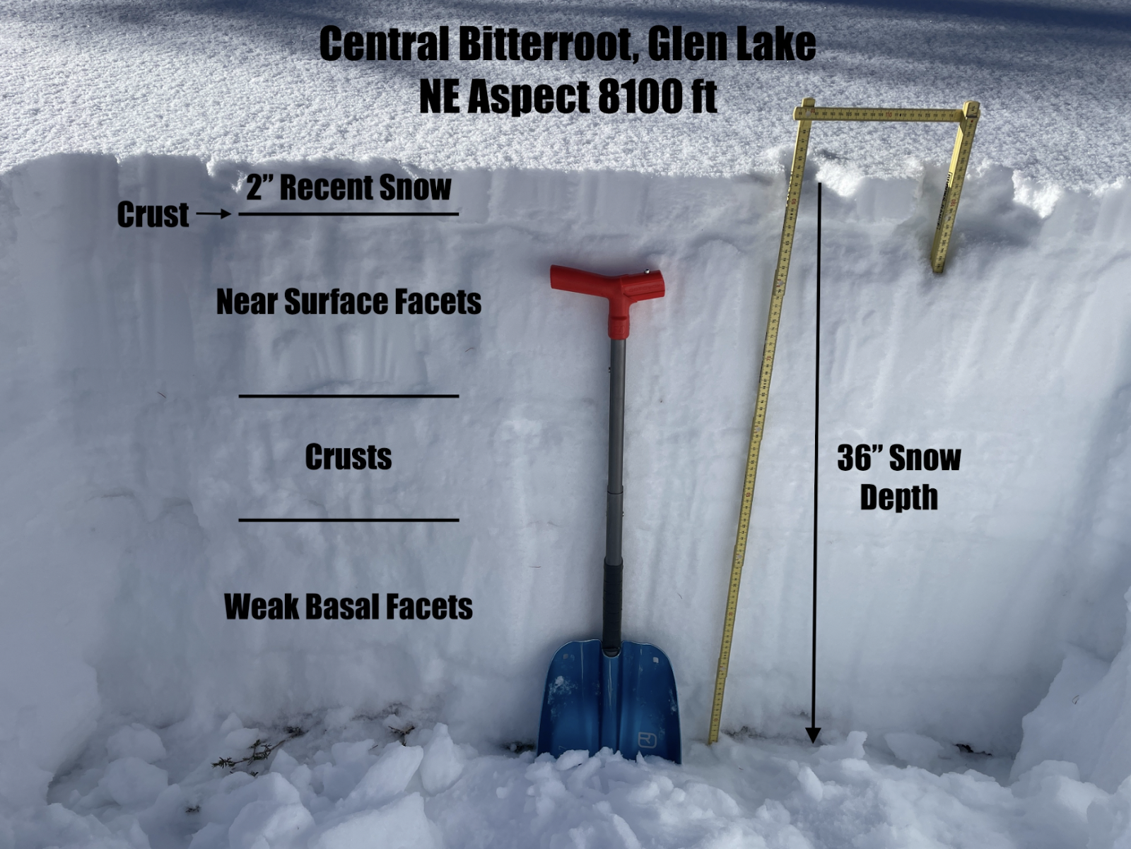
WCMAC forecaster snow pit from late December. Dug on a NE aspect around 8,100ft in the Bitterroots. (missoulaavalanche.org)
What does all of this mean as we move into 2024?
Overall, weather conditions contributed to the snowpack being thin and almost entirely composed of weak layers. The recipe for an avalanche is a slab over weak snow and a trigger. Currently, slabs only exist in isolated areas. When storms arrive and slabs of new snow form over these weak layers, we can expect the avalanche danger to rise. Be alert to any rapid changes such as new snow and wind loading.
In the meantime, while we wait, wish, and hope for old man Winter to pay us a visit…
- Consider posting your observations to the West Central Montana Avalanche Center observation page. Our forecast zones cover a large amount of terrain; any additional information can help us produce informed avalanche forecasts for the community!
- Brush up on your rescue skills! Now is the perfect time to check your gear; make sure it is functioning properly, and put your transceiver, probe, and shovel to good use.
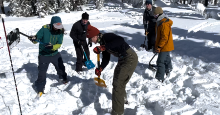
Avalanche rescue practice at Snowbowl’s Beacon Park during a Level 1 Recreational course with West Central Montana Avalanche Foundation. (photo: Katie Matthews)
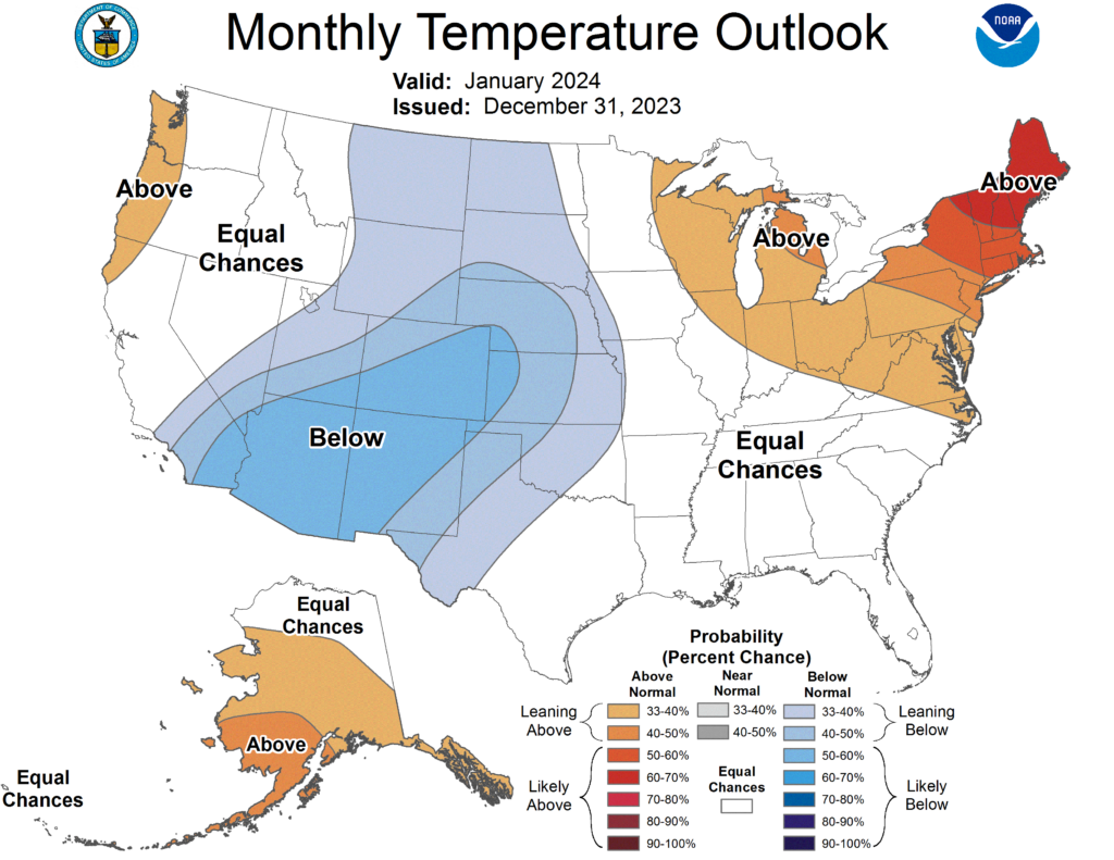
Monthly Temperature Outlook for the U.S. for January of 2024. Issued December 31st, 2023. (www.cpc.ncep.noaa.gov)
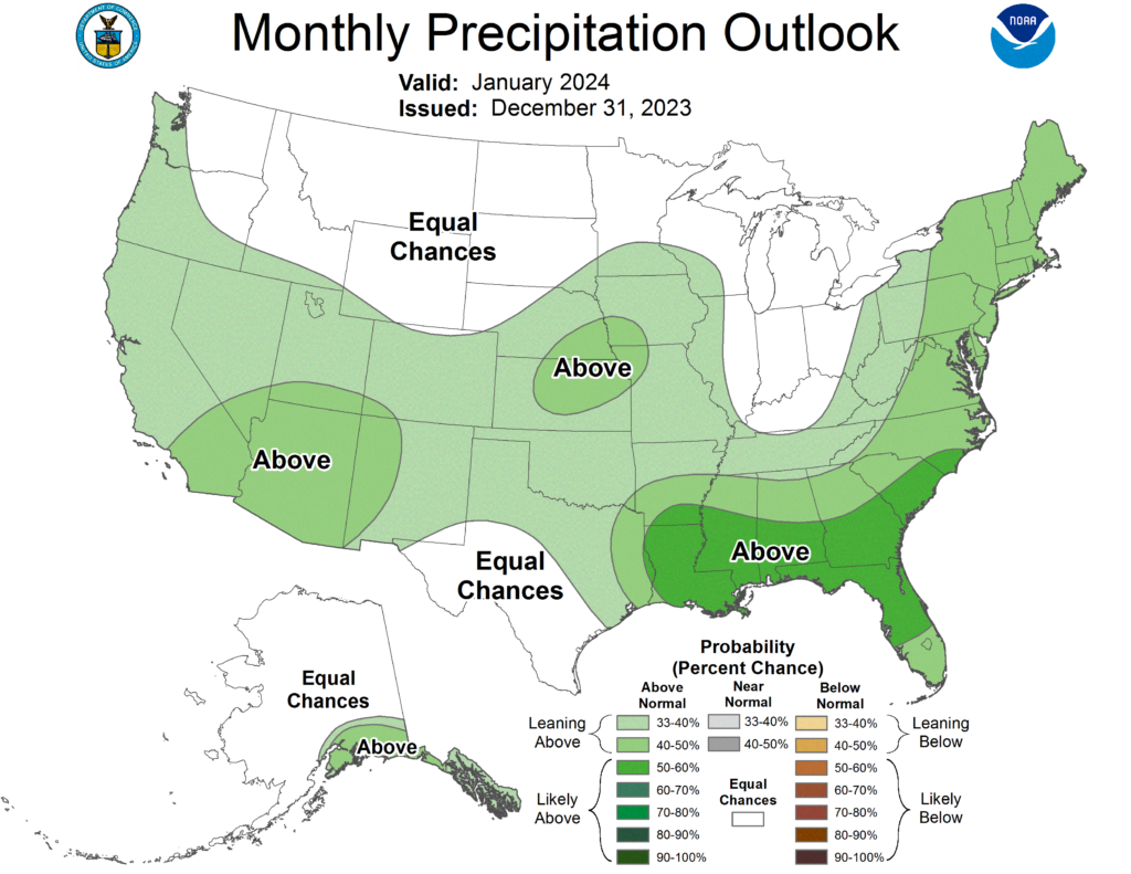
Monthly Precipitation Outlook for the U.S. for January of 2024. Issued December 31st, 2023. (www.cpc.ncep.noaa.gov)


