By WCMAC Forecaster Payton Schiff and Intern Katie Matthews
January
Like any good TV show, January was nothing short of continuous highs and lows. Lingering skepticism about the winter season hung in the air in early January. For what felt like a short, sweet moment, the snow graced us with its soft, glittering presence; a glimmer of hope that our ski season was not yet over. But all too soon, long periods of rain and unseasonably warm temperatures began to melt away our powder-filled dreams.
Weather Summary
The first significant storms of the year (January 7th-12th) deposited snow at all elevations marking the first significant load our snowpack had seen this season. The Bitterroot zone faired the best, seeing an average of 28 inches of new snow over this time period and 2.7 inches of SWE (snow water equivalent). The central Bitterroot was at the highest end of snow totals, where nearly 3 feet fell. This storm system was accompanied by intense and shifting wind on January 11th. A cold arctic airmass from the east moved in on the 12th, bringing below freezing temperatures and easterly wind until the 15th. We received another storm on the 18th that delivered up to 1 foot throughout the forecast region. This storm was also accompanied by strong wind that shifted from typical north and west to atypical east and south directions. Unseasonably warm conditions followed this wintery weather through the remainder of the month. We had above-average temperatures, freezing levels rose into upper elevations, and light to heavy rain fell at all elevations.
Snowpack Summary
Like most persistent slab problems, the weak layers built during the dry December weather continued to persist throughout January. Multiple persistent weak layers could be found throughout our snowpack, such as depth hoar, facets, crust/facet combinations, and buried surface hoar. Storm totals from the 7th-12th added the final necessary ingredient to a persistent slab avalanche recipe: a strong slab over weak snow.
Avalanche conditions became sensitive, especially in the central and southern Bitterroot, and the avalanche danger reached High by the 12th. This was due not only to weak snowpack structure but because of wind as well; forecasters listed very likely wind slab and likely persistent slab avalanche problems. Natural persistent slab avalanches were observed. Close calls and multiple reports of remotely triggered avalanches, shooting cracks, and whumpfing were reported just outside the Lost Trail Ski Resort in the days following. The avalanche danger reached High again on the 18th after the second significant storm of January for similar reasons: poor snowpack structure and wind. Forecasters once again listed very likely wind slabs on all aspects at upper and middle elevations as well as likely persistent slabs up to D2.5 in size.
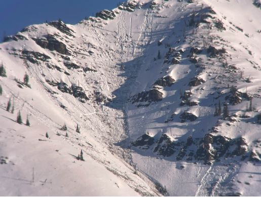
As weather transitioned to near spring-like conditions, the avalanche danger remained Considerable. Warm temperatures and rain on snow led forecasters to list wet loose avalanches on all aspects and elevations by the 27th. The persistent slab problem remained a big concern as rain on snow created complicated and uncertain avalanche conditions. Multiple close calls were once again reported, and avalanche danger remained the highest in the southern Bitterroot, where a layer of buried surface hoar was especially well preserved. WCMAC forecaster Cam put together an excellent review of avalanche activity from this time period that you can watch by clicking here. We then saw an impressive avalanche cycle on the 28th and 29th where 30 natural avalanches were reported due to continued warm temperatures and sunshine. A number of these avalanches were large wet slab avalanches.
February
An eventful January left us still feeling rather discombobulated about the state of the season. Whatever TV show Ullr had us sitting down for in January truly had us hooked now…
Weather Summary
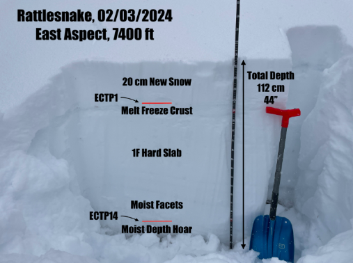
Unseasonably warm weather continued into February until the 3rd when a series of storms impacted all three zones. Each zone received up to around 1 foot of new snow through the 4th. Then, from the 5th through the 8th, storms in quick succession brought an additional 6-18 inches. The upper end of these snow totals fell in the Bitterroot zone. The next storm system from the 12th through the 15th impacted primarily the Seeley Lake and southern Bitterroot zones. One and a half feet of new snow with 1.6 inches of SWE fell on the 12th in Seeley Lake, and then up to 2.5 feet fell in the southern Bitterroot on the 15th. During this time, another arctic air mass with strong east wind and cold temperatures blew through on Valentine’s Day. The weather was generally uneventful until the 24th. The new low pressure system that moved in on the 24th impacted mostly the Bitterroot zone again. By the 25th, around 1.5 feet of new snow and 3.2 inches of SWE fell, accompanied by very strong winds. This storm system was relatively warm, and rain fell at lower elevations.
Ongoing snowfall and strong wind speeds continued through the end of the extra-long Leap Year month into March. However, due to periods of warm weather and rain, the snowpack at lower elevations was very minimal and nearly nonexistent on southerly aspects. The difference between lower and upper elevations became very stark. At upper elevations, eventful weather and avalanche problems prevailed.
Snowpack Summary
The warm weather kept avalanche danger heightened, and forecasters kept a wet loose avalanche problem on the problem list on the 1st (the persistent slab problem was on the list as well, which is discussed in depth at the end of this section). They dropped the wet loose problem on the 2nd and dropped the avalanche danger to Moderate. By the 4th, avalanche danger was back to Considerable while the aforementioned storm passed through. Seven small and large human triggered slab avalanches were reported through the 15th; thankfully, no one was caught.
The snowpack settled out during the respite from stormy weather, and avalanche danger dropped to Low on the 22nd and 23rd. Some small wind slab and wet loose avalanches were reported during this time. When the next storm system rolled through, forecasters bumped the avalanche danger up to High by the 26th, citing very likely wind slabs as the primary culprit. By the 29th, forecasters dropped the danger to Considerable but noted that danger could still be High in the Bitterroot where the most significant snowfall occurred.
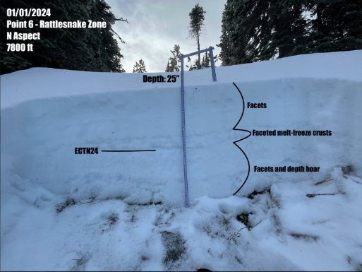
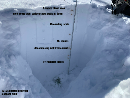
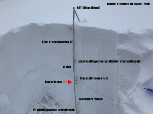
The persistent slab problem remained on the avalanche forecast problem list throughout the entire month, fluctuating from unlikely to likely in response to storms depositing new loads onto weak snowpack structure and liquid water moving through the snowpack from warm weather. Observations found that the most problematic weak layer was facets above a melt freeze crust found midway down in the snowpack. Forecasters surmised that these facets initially formed as near surface facets on the 10th. Near crust facets could also be found below this crust throughout the month, as well as basal facets near the ground, but both layers proved to be largely unreactive. Three confirmed persistent slab avalanches were reported; the first was a large unintentionally triggered avalanche in the Seeley Lake zone on the 15th, the second was a large natural avalanche in the Bitterroot zone on the 17th, and the third was an intentionally triggered avalanche in the Bitterroot on the 24th. By the end of the month, forecasters were still predicting persistent slab avalanches up to D2.5 in size.
March
Although backcountry skiing and sledding are far from over, March was the season finale for the West Central Montana Avalanche Center forecast season. And we all know the finale can make or break a good TV show!
Weather Summary
The beginning of March marked the tail end of a low pressure system that impacted all three zones throughout the week prior. The Seeley Lake, northern Bitterroot, and central Bitterroot zones saw the most snowfall from this system and came away with 3.1”, 3.2”, and 4.6” of SWE, respectively, by the 3rd. Unfortunately, during much of this time, the Point 6 weather station, which serves as the best upper elevation wind data for the forecast region, was rimed up and not functional. Alternate wind data showed light-moderate wind out of the south and west; however, observers documented significant flagging on ridge tops.
The weather stayed calm, with seasonal upper elevation temperatures in the 20s and low 30s (F) until the next storm system began impacting the region on the 11th. This system again favored the Seeley Lake, northern Bitterroot, and central Bitterroot zones, which came away with 1.3”, 0.9”, and 1.5” of SWE, respectively. This system was quickly followed by a long period of unseasonably hot and sunny weather starting on the 15th. Upper elevation daytime temperatures reached close to 60 degrees (F), and only some moderate wind offered any respite. At night, temperatures hovered around freezing. This decidedly warm period lasted until March 20th.
Temperatures began to drop on the 21st to more seasonal numbers but remained elevated until the 24th. The forecast region then received increments of new snow through the 28th. An average of 12-14 inches was observed throughout the Bitterroot zone, and the Stuart SNOTEL in the Rattlesnake zone reported 11 inches. The Seeley Lake zone received approximately 7 inches. Much of the new snow that fell was moderate to high density snow, and overall, the wind remained light throughout the low pressure system but was elevated to moderate for a period of time on the 27th.
The month finished out with unremarkable weather. Cloud coverage shifted from mostly clear to mostly cloudy throughout the day and night, with very little precipitation. The wind was calm or light and from typical south and west directions. Daytime temperatures hovered in the high 30s and low 40s (F) with the exception of high 20s reported in the Rattlesnake zone. Nighttime temperatures dropped below freezing.
Snowpack Summary
As snow continued to fall at the beginning of the month, the avalanche danger was listed at Considerable on the 1st, with likely wind slab and possible persistent slab avalanches. Forecasters dropped danger to Moderate for the 2nd and 3rd and dropped the likelihood to possible wind slab and unlikely persistent slab avalanches. Two observers reported natural slab avalanches during this time that were triggered by large cornice fall, and two snowmobilers had a close call with a large persistent slab avalanche near Philipsburg outside of the forecast region.
Observations reported excellent skiing and riding conditions until the 7th when wet snow began making an appearance. Observers noted small wet loose avalanches up to upper elevations in all three zones, as well as multiple cornice triggered avalanches in the Bitterroot and Seeley Lake zones. Forecasters kept the avalanche danger at Moderate, with wet snow instabilities being their chief concern through the 9th.
On the 9th, forecasters made the long-awaited decision to drop the persistent slab problem from the forecast list. They noted that buried weak layers – namely, small facets above a melt freeze crust buried midway down in the snowpack – had gained significant strength over the previous few weeks and had been tested by multiple storms resulting in only isolated slab avalanches with large triggers.
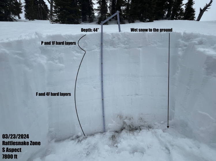
On March 12th, a skier unintentionally triggered a large avalanche on a north aspect just below 8000 ft in the southern Bitterroot, which tragically resulted in a fatality. You can read the preliminary accident report here. The weak layer in this avalanche was a layer of large buried surface hoar grains that had been buried on February 2nd. Forecasters returned the persistent slab problem to the forecast for all aspects at upper elevations and closely examined the snowpack throughout the forecast region in the days following the accident. They determined that this layer of buried surface hoar had likely been isolated within the southern Bitterroot zone. Nonetheless, they kept the persistent slab problem on the avalanche problem list for all three zones due to uncertainty in its distribution.
The snowpack began to heat up with the spring-like weather that began on the 15th. By the 17th, the avalanche danger reached High, with very likely wet loose avalanches everywhere except upper elevation, northerly slopes. By the 23rd, forecasters were predicting wet slab avalanches on south and west aspects as observations of wet snow to the ground had been reported. The snowpack indeed went through a significant avalanche cycle; numerous wet loose avalanches were reported on all aspects and elevations, and reports of wet slab avalanches trickled in.
The avalanche danger was back to Low by the 24th as seasonal weather returned and the snowpack had gone through its peak of instability. The snowpack on southerly slopes was characterized by numerous melt freeze crust and ice layers within, and moist snow to the ground remained. Forecasters relegated the unlikely persistent slab problem to just upper elevation north aspects.
With around 1 foot of new snow on the ground by the 28th, the avalanche danger was bumped up to Moderate and stayed so until the end of the month. Forecasters reasoned that new snow influenced by sun, warm temperatures, and little wind would make wet loose avalanches possible on all aspects except northerlies. They also anticipated possible wind slabs on upper elevation leeward slopes due to the increased wind speeds on the 27th. The unlikely persistent slab problem remained on the avalanche problem list, as isolated areas of poor snowpack structure continued to be found on upper elevation north aspects.
Closing Notes
A huge thank you to everyone who participated in community events and submitted observations to the West Central Montana Avalanche Center website. Your involvement was greatly appreciated, and provided essential information for the forecasters to deliver high quality forecast products.
As skiing and riding will continue for months to come, please continue to submit your observations to the West Central Montana Avalanche Center’s observations page. This information is extremely helpful not only to our forecasters during the forecast season but to our backcountry community as a whole. Observations can be anything: road and trail conditions, stable or unstable snowpack findings, sunny or stormy weather, and natural or human-triggered avalanches.
Resources
Visit skipig.org to get succinct summaries of weather and avalanche danger trends.
The WCMAC observations page has not only public and forecaster observations from the season but a list of all reported avalanches and a visuals page with graphs showing instability over time.
Revisit all published WCMAC forecasts from this season and past seasons on the forecast archive page.
Find us on Instagram by searching for @wcmavalanche or on Facebook by searching for West Central Montana Avalanche Foundation.