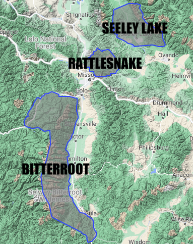
The West Central Montana Avalanche Center forecasts for a large region. The region spans from Lost Trail Pass in the south through the town of Seeley Lake in the north – a distance of 150 miles or a 3-hour drive. Weather and snowpack patterns can vary greatly over such a large distance. To provide a more accurate product, the region is split up into three forecast zones: Bitterroot, Rattlesnake, and Seeley Lake. The Bitterroot Forecast Zone covers the Bitterroot Mountains from Lost Trail Pass in the south to Lolo Pass in the north. The Rattlesnake Forecast Zone covers the Rattlesnake Mountains north of Missoula. The Seeley Lake Forecast Zone covers the mountains surrounding the town of Seeley Lake, MT.
Even after splitting the forecast area up into three forecast zones, each zone is still large. Conditions can vary significantly even within one zone. To help us address differences in conditions within each of our zones, we often refer to specific areas within the zones. In the next couple of paragraphs, I will describe some of the common areas we refer to within each forecast zone and provide basic maps of the different areas. It’s important to note that although we’ve drawn hard boundaries between areas, these are just guidelines to help communicate common trends. In reality, conditions change over fluid boundaries.
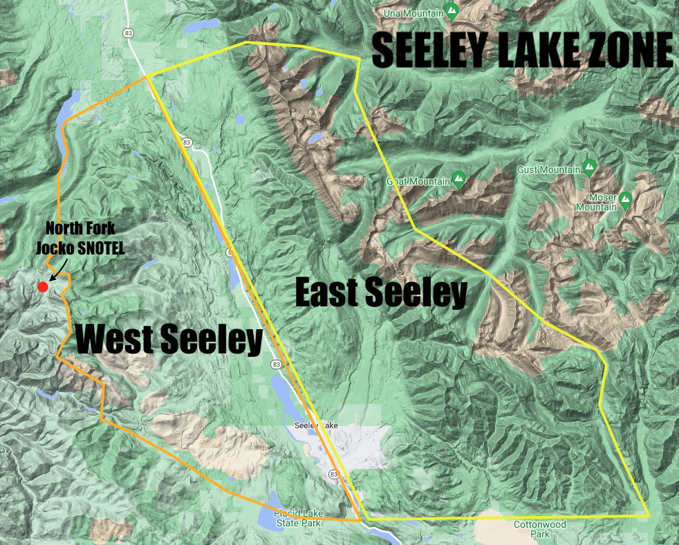
The Seeley Lake Forecast Zone is split down the middle by Highway 83. On the east side of the highway is the East Seeley area, which includes the Southern Swan Range. The terrain on the west side of the highway and east of the Mission Mountains Tribal Wilderness is the West Seeley area. The North Fork Jocko SNOTEL site at 6,330 ft is the closest weather station to the Seeley Lake zone and provides useful information on snowfall and temperatures.
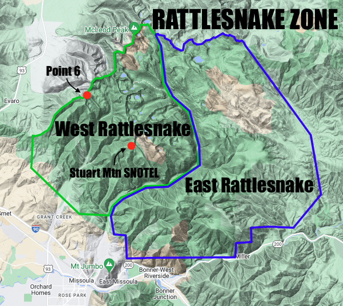
The Rattlesnake Forecast Zone encompasses two areas: the East Rattlesnake and West Rattlesnake, separated by Rattlesnake Creek. East Rattlesnake is most commonly accessed from Montana Snowbowl Ski Area. In the West Rattlesnake, the backcountry near Marshal Mountain and Lockwood Point are popular locations. The Stuart Mountain SNOTEL site at 7,400 ft provides snowfall and temperature information in the Rattlesnake zone. The Point 6 weather station at 7,897 ft near Snowbowl is a great resource for ridgeline wind and temperature information.
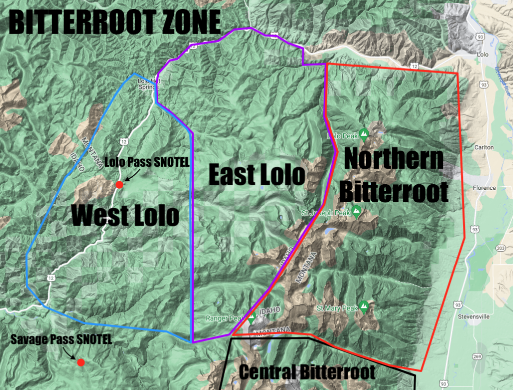
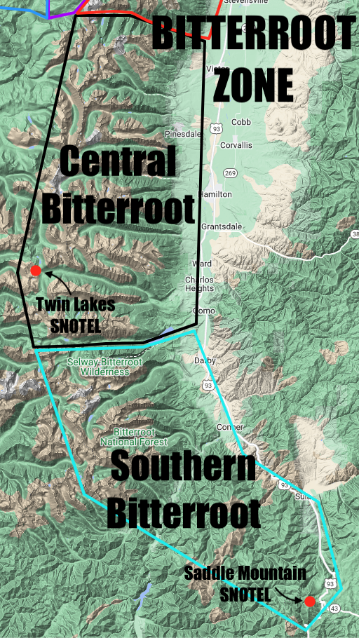
The Bitterroot Forecast Zone is especially large, and in the future, we hope to split it up into smaller zones. For now, we refer to five distinct areas within the zone. The Southern Bitterroot stretches from Lost Trail Pass to Lake Como. It includes the Backcountry near Lost Trail Ski Area and some of the highest peaks in the range, including Trapper Peak. The Saddle Mountain SNOTEL site at 7,940 ft provides snowfall and temperature information in the Southern Bitterroot. The Central Bitterroot continues from Lake Como up to Big Creek. It includes several popular backcountry locations, including the Lost Horse drainage and Gash Point. The Twin Lakes SNOTEL site at 6,400 ft is a great resource for snowfall and temperature information in the Central Bitterroot. The Northern Bitterroot extends from Big Creek up to the northern end of the Bitterroot Range. Bass Creek is a popular backcountry location in this area.
Additionally, the Bitterroot Forecast Zone includes the Lolo Pass area. The Lolo Pass area is accessed from Highway 12 and can be split into two more specific areas. The West Lolo area includes the terrain surrounding Lolo Pass itself. Popular backcountry locations include the G Spot, Crystal Amphitheater, and Mount Fuji. The East Lolo area covers the terrain on the western side of the Bitterroot Crest that is generally accessed via snowmobile from Highway 12. The Lolo Pass SNOTEL site at 5,240 ft is a useful resource for snowfall and temperature information in the Lolo Pass area. The Savage Pass SNOTEL site at 6,170 ft is located just outside of the forecast area and can provide helpful snowfall and temperature information as well.