Posted:
Feb 8, 2021 @ 6:59 am

The Avalanche Warning is terminated this morning.

The avalanche danger in the west central Montana backcountry is HIGH on leeward slopes and CONSIDERABLE on all other slopes. Dangerous avalanche conditions exist and travel in avalanche terrain is not recommended. 

Good Morning. This is Jeff Carty with the West Central Montana Avalanche Center advisory on Monday, February 8th, 2021. This advisory does not apply to operating ski areas and expires at midnight tonight. The USDA Forest Service is solely responsible for its content.

Weather and snowpack

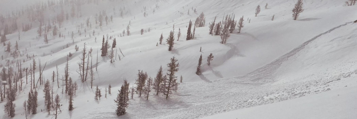
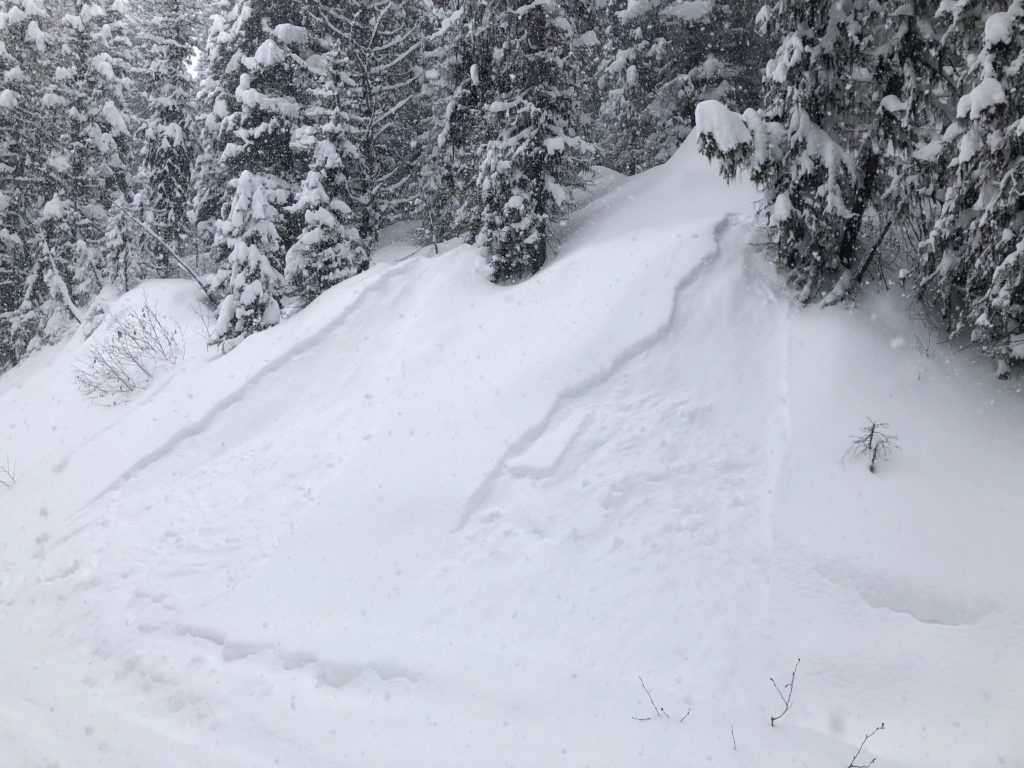
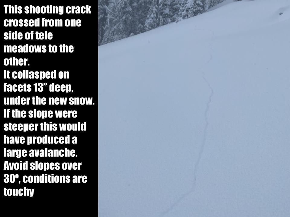
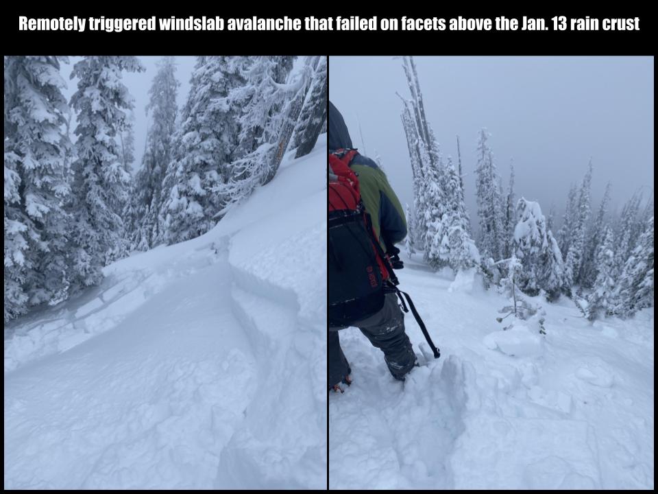
In the past week, the forecast area has received a massive amount of snow. 4.3” of SWE fell on the southern Missions, 3.1” in the Rattlesnake, 4.4″ in the central Bitterroot, and 2.8″ in the southern Bitterroot. This is a huge stress on the snow pack, translating to up to 4 feet of new snow, and it is still adjusting to the load. Of particular concern are faceted areas that were showing signs of weakness before the storm. Forecast area wide, mid elevations had well developed facets and depth hoar, as did the Rattlesnake at all elevations. These instabilities are now up to 6′ below the new snow and could produce very large destructive avalanches. In addition, near surface facets and facet/crust combo from January 13 underlie much of the new snow. These were collapsing and producing avalanches over the weekend under only part of the load we now have. More snow is expected today.

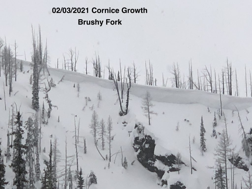
Winds have increased to moderate and are transporting ample new snow to leeward slopes and creating dangerous windslab that could be well over 6 feet thick in spots. Prior to the storm, cornices were already large and collapsing. Any that remain are unstable, unpredictable, and could trigger larger avalanches if they fall. 

In the past 7 days, there have been 15 avalanche fatalities in the US, including one in the northern Swans on Saturday. This is the most avalanche deaths in a week since 1910. The snowpack throughout the western US is unstable and precarious. Don’t add to the numbers. Now is not the time to push into steep terrain. The snowpack needs time to settle out and bond. 

The Bottom Line

Travel in avalanche terrain is not recommended, dangerous avalanche conditions exist. Avoid slopes over 30º and runout zones. You can trigger an avalanche remotely from the side, below, or above you. Natural avalanches are likely, human triggered avalanches in wind slab are certain.

Ski and ride safe.


READ FULL ADVISORY  

Problem 1 - Wind Slab and Cornices

  • TYPE

    wind-slabs

    Wind Slabs

    Release of a cohesive layer of snow (a slab) formed by the wind.  Wind typically erodes snow from the upwind sides of terrain features and deposits snow on the downwind side.  Wind slabs are often smooth and rounded and sometimes sound hollow, and can range from soft to hard. Wind slabs that form over a persistent weak layer (surface hoar, depth hoar, or near-surface facets) may be termed Persistent Slabs or may develop into Persistent Slabs.

  • SIZE

    5-6

    2-3 (Large)

    The potential size of avalanche resulting from this problem.

  • LIKELIHOOD

    Likelihood-8

    Very Likely/Certain

    The likelihood of an avalanche resulting from this problem.

  • ADDED DANGER

    Increased Slope Danger

    Increased/Added Danger

    There is an increased risk of avalanches on these slopes:

    N - North
    NE - Northeast
    E - East
    SE - Southeast
    S - South

Moderate winds are loading slopes with ample new snow. Cross loading is also a concern.

Wind slab will be deep and destructive. Human triggered avalanches are certain.

Cornice are growing and precarious. Cornice fall could trigger larger avalanches. Give them a wide berth.

Avoid wind loaded terrain and do not travel under cornices. Stay well away from the top, they can break far back onto flat ground.

Problem 2 - Persistent slab

  • TYPE

    persistent-slabs

    Persistent Slabs

    Release of a cohesive layer of soft to hard snow (a slab) in the middle to upper snowpack, when the bond to an underlying persistent weak layer breaks.  Persistent layers include: surface hoar, depth hoar, near-surface facets, or faceted snow. Persistent weak layers can continue to produce avalanches for days, weeks or even months, making them especially dangerous and tricky. As additional snow and wind events build a thicker slab on top of the persistent weak layer, this avalanche problem may develop into a Persistent, Deep-Slab.

  • SIZE

    5-6

    2-3 (Large)

    The potential size of avalanche resulting from this problem.

  • LIKELIHOOD

    Likelihood-5

    Likely

    The likelihood of an avalanche resulting from this problem.

  • ADDED DANGER

    Increased Slope Danger

    Increased/Added Danger

    There is an increased risk of avalanches on these slopes:

    N - North
    NE - Northeast
    E - East
    SE - Southeast
    S - South
    SW - Southwest
    W - West
    NW - Northwest

Mid elevations and areas that were shallow prior to the storm have weak faceted snow as the base. These layers could fail under the weight of the new snow or a skier or rider. Shallower avalanches or cornice fall may step down to these deep persistent layers causing large destructive slides.

The January 13 crust facet combo is now 2 to 4 feet deep and reawakening. Avalanches are sliding on this layer as well as a faceted layer above it.

It is very possible to trigger an avalanche remotely from the side, below and above.

Avoid slopes over 30º and provide wide margins below and adjacent to avalanche slopes.

FORECAST & OUTLOOK

Snow bands will continue through the day with another 3-6 inches of snow possible in the Rattlesnake and up to a foot in the Bitterroots by late today. Some drainage eastwinds this morning are possible. Very cold temperatures and light snow are expected through Thursday when the next potential system will begin to overrun the area.

This information is the sole responsibility of the Forest Service and does not apply to operating ski areas. The avalanche danger rating expires at midnight tonight but the information can help you make a more informed decision regarding travel in avalanche terrain for the next few days.

Our advisory area includes National Forest System lands in the Bitterroot Mountains from Lost Trail Pass north to Granite Pass, the Rattlesnake Mountains north of Missoula and the Southern Swan and Mission Mountains near Seeley Lake, MT. Avalanche information for the Lookout Pass/St. Regis Basin area is available from the Idaho Panhandle Avalanche Center.