Posted:
Apr 3, 2021 @ 6:54 am

The avalanche danger in the west central Montana backcountry is CONSIDERABLE.

Good Morning. This is Jeff Carty with the West Central Montana Avalanche Center advisory on Saturday, April 3, 2021. This advisory is sponsored by Spark R&D. This advisory does not apply to operating ski areas and expires at midnight tonight. The USDA Forest Service is solely responsible for its content.

Weather and Snowpack

Mountain temperatures this morning ranged from 30º to 41º to. There was an inversion last night with higher temperatures at upper elevations. Temperatures are forecast to reach 59º above 6000′ today.  Freezing levels will be at least 7500’, potentially climbing to 10000’.  The sun will rapidly warm southern aspects. Winds will be light out of the southwest. 

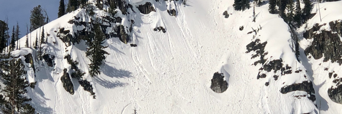
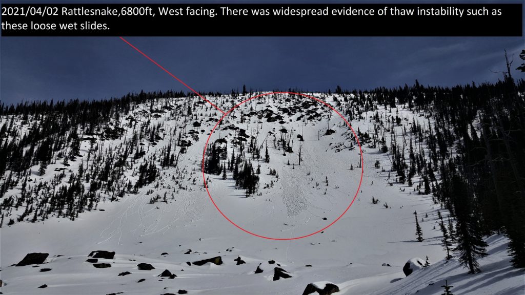
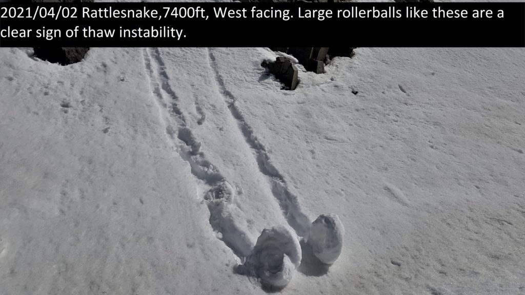
Last night was the second in a row with elevated temperatures that did not dip below freezing. Temperatures remained higher than the previous night so less cooling of the snow surface occurred. Strong sun and high temperatures yesterday added considerable warmth to the snowpack, saturating the snow on all solar aspects. Any freeze that happened on the snow surface last night will be shallow. By noon yesterday, the snowpack at 7600’ on south aspects was saturated throughout. Small loose wet slabs were easy to trigger and the snowpack lost cohesion throughout the day. This will happen earlier today. 

The risk of large wet avalanches increases today. Freezing levels rising to above 7500’ and solar warming will destabilize the snow further. Loose wet avalanches could entrain considerable snow and have the potential to be much larger than the slides seen yesterday. The potential also exists for very large wet slabs to release. The January 13th crust still exists deep in the snowpack. While bonded when dry, warm wet conditions could reawaken it or other dormant layers.

Once the snow warms up, is saturated, or you are punching past mid boot, it’s time to move to shadier aspects. If you are post-holing in wet snow stay well away from avalanche terrain. 

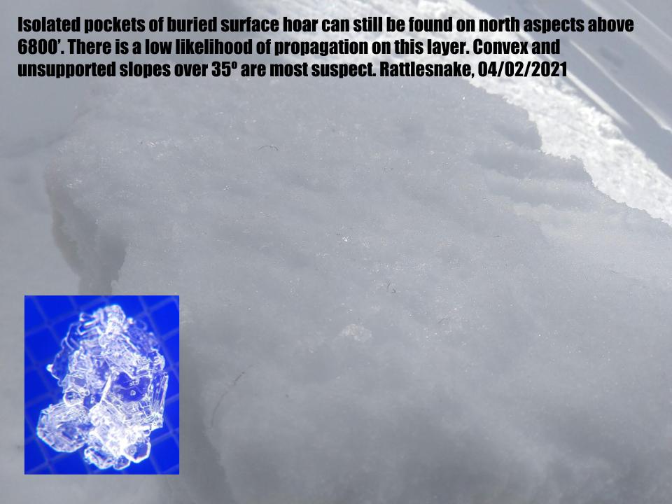
North aspects were dry yesterday above 6800’ in the Rattlesnake. However, last night’s elevated temperatures may have affected the snow. We were still able to find isolated pockets of buried surface hoar and near surface facets yesterday on the north. There is a slight possibility to trigger a slide on these in steep, unsupported terrain. Avoiding convexities over 35º is one way to manage this problem. 

Timing will be difficult today, and the time window for stable corn skiing may not exist at all, with most slopes not refreezing overnight. Given the unpredictability of wet slides, and the generally poor skiing and riding conditions of saturated snow, avoiding all avalanche slopes with solar warming is a good risk management option today.

The Bottom Line 

Above freezing overnight temperatures combined with sun warming make loose and wet slab avalanches likely today. The extended warmth increases the potential size of avalanches and we may see very large avalanches in specific locations. Move to shadier aspects as roller balls start and you sink past mid boot in wet snow. Plan your exit from the backcountry so you are not crossing southerly or westerly avalanche terrain late in the day. On north slopes, above 6800’, faceted layers have a slight potential to propagate. Avoiding convex north slopes over 35º is the easiest management. Stay alert for red flags. Carry a beacon, shovel, and probe.

Public Observations

Thank you to everyone who has taken the time to send in a public observation. Please keep sharing what you find and see while out in the backcountry. You can now text us your observations to (406) 219-5566 when you don’t have time to fill out the observations page.

Ski and ride safe.


READ FULL ADVISORY  

Problem 1 - Wet Loose

  • TYPE

    loose-wet

    Loose Wet

    Release of wet unconsolidated snow or slush. These avalanches typically occur within layers of wet snow near the surface of the snowpack, but they may quickly gouge into lower snowpack layers. Like Loose-Dry Avalanches,they start at a point and entrain snow as they move downhill, forming a fan-shaped avalanche. They generally move slowly, but can contain enough mass to cause significant damage to trees, cars or buildings. Other names for loose-wet avalanches include point-release avalanches or sluffs. Loose-wet avalanches can trigger slab avalanches that break into deeper snow layers.

  • SIZE

    5-6

    2-3 (Large)

    The potential size of avalanche resulting from this problem.

  • LIKELIHOOD

    Likelihood-4

    Possible/Likely

    The likelihood of an avalanche resulting from this problem.

  • ADDED DANGER

    Increased Slope Danger

    Increased/Added Danger

    There is an increased risk of avalanches on these slopes:

    E - East
    SE - Southeast
    S - South
    SW - Southwest
    W - West

48hrs of above freezing temperatures have created a warm saturated snowpack that will continue to lose cohesion with sun and warm temperatures today.

The risk of loose wet avalanches increases through the day as does the potential size. In many places the snowpack has become isothermal and loose wet avalanches can build significant mass and could run to ground.

In certain locations, large south and west faces or avalanche paths such as Lost Horse or Pyramid Peak, loose wet avalanches have the potential to entrain significant snow, grow very large and run to valley bottom. Large wet slabs could also be triggered.

Upper elevations remained warmer last night increasing the risk of loose wet avalanches beginning in the alpine.

Avoid avalanche terrain with sun warming today.

Problem 2 - Wet slabs

  • TYPE

    wet-slabs

    Wet Slabs

    Release of a cohesive layer of snow (a slab) that is generally moist or wet when the flow of liquid water weakens the bond between the slab and the surface below (snow or ground). They often occur during prolonged warming events and/or rain-on-snow events. Wet slabs can be very destructive.

  • SIZE

    6-7

    3 (Large-Very Large)

    The potential size of avalanche resulting from this problem.

  • LIKELIHOOD

    Likelihood-4

    Possible/Likely

    The likelihood of an avalanche resulting from this problem.

  • ADDED DANGER

    Increased Slope Danger

    Increased/Added Danger

    There is an increased risk of avalanches on these slopes:

    E - East
    SE - Southeast
    S - South
    SW - Southwest
    W - West

The possibility of wet slabs is increasing with continued warmth. Crusts, such as the January 13 crust, exist deep in the snowpack and could be reawakened by warmth and water in the snowpack. These could be very large and destructive.

The likelihood will increase throughout the day with increasing temperatures and solar warming.

Avoid avalanche terrain with sun warming today.

Problem 3 - Glide Avalanches

  • TYPE

    glide-avalanche

    Glide Avalanches

    Release of the entire snow cover as a result of gliding over the ground. Glide avalanches can be composed of wet, moist, or almost entirely dry snow. They typically occur in very specific paths, where the slope is steep enough and the ground surface is relatively smooth. The are often proceeded by full depth cracks (glide cracks), though the time between the appearance of a crack and an avalanche can vary between seconds and months. Glide avalanches are unlikely to be triggered by a person, are nearly impossible to forecast, and thus pose a hazard that is extremely difficult to manage.

    Predicting the release of Glide Avalanches is very challenging. Because Glide Avalanches only occur on very specific slopes, safe travel relies on identifying and avoiding those slopes. Glide cracks are a significant indicator, as are recent Glide Avalanches.

  • SIZE

    6-7

    3 (Large-Very Large)

    The potential size of avalanche resulting from this problem.

  • LIKELIHOOD

    Likelihood-3

    Possible

    The likelihood of an avalanche resulting from this problem.

  • ADDED DANGER

    Increased Slope Danger

    Increased/Added Danger

    There is an increased risk of avalanches on these slopes:

    N - North
    NE - Northeast
    E - East
    SE - Southeast
    S - South
    SW - Southwest
    W - West
    NW - Northwest

Glide cracks are opening more quickly with continued warmth. Significant water from the thaw is lubricating the ground under the snowpack and full depth avalanches are possible.

Avoid all slopes with glide cracks or snow with a wrinkled appearance indicating snow creep.

Problem 4 - Cornice Fall

  • TYPE

    cornices

    Cornices / Cornice Fall

    Release of an overhanging mass of snow that forms as the wind moves snow over a sharp terrain feature, such as a ridge, and deposits snow on the down-wind side. They range from small wind lips of soft snow to large overhangs of hard snow that are 30 feet (~10 meters) or taller. They can break off the terrain suddenly and pull back onto the ridge top and catch people by surprise even on the flat ground above the slope. Even small cornices can have enough mass to be destructive and deadly. Cornice fall can entrain loose surface snow or trigger slab avalanches.

  • SIZE

    3-4

    1-2 (Small-Large)

    The potential size of avalanche resulting from this problem.

  • LIKELIHOOD

    Likelihood-5

    Likely

    The likelihood of an avalanche resulting from this problem.

  • ADDED DANGER

    Increased Slope Danger

    Increased/Added Danger

    There is an increased risk of avalanches on these slopes:

    N - North
    NE - Northeast
    E - East
    SE - Southeast
    S - South

Cornices are being continually weakened by warmth and sun, the likelihood of cornice fall will increase throughout the day.

Cornice fall will likely trigger avalanches today. Stay out from under cornices and well away from the top, they can break much further back than expected.

Problem 5 - Persistent weak layers

  • TYPE

    persistent-slabs

    Persistent Slabs

    Release of a cohesive layer of soft to hard snow (a slab) in the middle to upper snowpack, when the bond to an underlying persistent weak layer breaks.  Persistent layers include: surface hoar, depth hoar, near-surface facets, or faceted snow. Persistent weak layers can continue to produce avalanches for days, weeks or even months, making them especially dangerous and tricky. As additional snow and wind events build a thicker slab on top of the persistent weak layer, this avalanche problem may develop into a Persistent, Deep-Slab.

  • SIZE

    3-4

    1-2 (Small-Large)

    The potential size of avalanche resulting from this problem.

  • LIKELIHOOD

    Likelihood-2

    Unlikely/Possible

    The likelihood of an avalanche resulting from this problem.

  • ADDED DANGER

    Increased Slope Danger

    Increased/Added Danger

    There is an increased risk of avalanches on these slopes:

    N - North
    NE - Northeast
    NW - Northwest

Isolated pockets of buried facets and surface hoar exist from 6″ to 18″ deep on north slopes. Overall these are well bonded but a slight possibility exists to trigger these layers in steep convex or unsupported terrain greater than 35º.

VIDEO

FORECAST & OUTLOOK

Temperatures are forecast to rise to 59º above 6000′ today. North of Lolo Pass high thin clouds are expected, but not enough to attenuate sun warming. South of Lolo skies should be clear and the sun will be out in full force. Warm temperatures continue overnight and tomorrow. Clouds increase tomorrow afternoon with precipitation potentially arriving Sunday night. Monday brings a change with dropping temperatures and another round of snow in the mountains.

This information is the sole responsibility of the Forest Service and does not apply to operating ski areas. The avalanche danger rating expires at midnight tonight but the information can help you make a more informed decision regarding travel in avalanche terrain for the next few days.

Our advisory area includes National Forest System lands in the Bitterroot Mountains from Lost Trail Pass north to Granite Pass, the Rattlesnake Mountains north of Missoula and the Southern Swan and Mission Mountains near Seeley Lake, MT. Avalanche information for the Lookout Pass/St. Regis Basin area is available from the Idaho Panhandle Avalanche Center.