Posted:
Dec 12, 2014 @ 5:56 am

There is MODERATE avalanche danger in the west central Montana backcountry above 7000 feet, on slopes steeper than 35degrees.  Slab avalanches are possible on steep slopes (>35 deg.) that have a relatively shallow snowpack and have rocky outcrops or cliffs. Any rain on the snow will increase the chances of a slab avalanche and/or the chance of small surface slides. The avalanche danger is LOW in other terrain in the advisory area.

Good Morning, this is Dudley Improta with the west central Montana avalanche advisory for December 12, 2014. This danger rating does not apply to operating ski areas and expires at midnight tonight (Dec. 12).

Weather and Snowpack

This morning mountain winds are blowing  out of the south and east at 7 to 16 mph and gusting into the 30 mph range .  Mountain temperatures are above freezing up to 8000 feet.

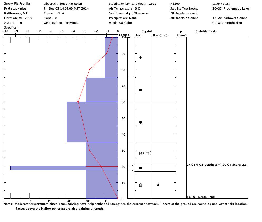
Warm temperatures have strengthened the snowpack. Snotels across the advisory area indicate the snow has settled anywhere from 3 to 6 inches over the last 3 days; a sign of stability.

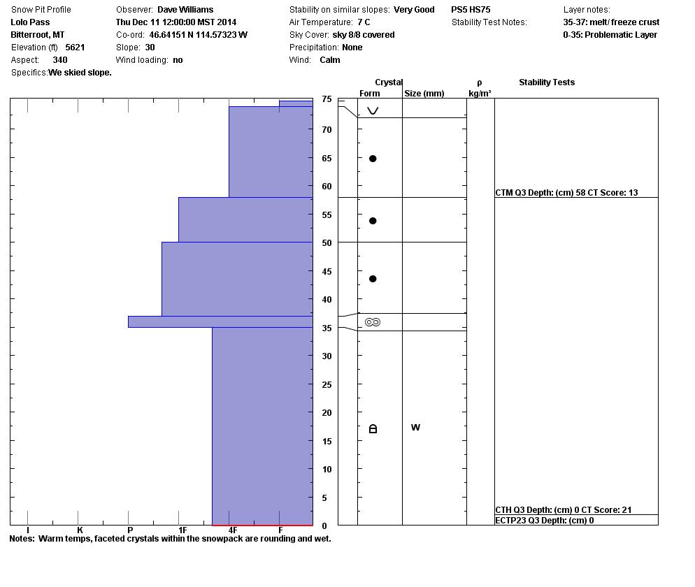
But, we are still seeing facets at the bottom of the snowpack created in the November cold spell. At higher elevations (>7000 feet) on steep slopes (>35 degrees), particularly where there is rocky terrain, it’s possible this layer could produce a large slab avalanche.

The top layer of wet snow could release on steep slopes as well. These wet sluffs would  be small and not nearly as consequential as a slab from the ground level.

Any rain on the snow will increase the chance of either one of these events.

Weather Forecast and Avalanche Outlook

There is a chance of rain in the mountains today, and again the temperatures up to 8000 feet may reach into the 40’s (F). Temperatures are predicted to drop tonight and snow levels may lower. The higher elevations may pick up 1 to 3 inches of snow. Winds may gust out of the south and west up to 30 mph. Although the snow predicted is modest,  it may be deposited on a melt-freeze crust and accumulate on lee slopes. I would expect the avalanche danger to rise ever so slightly.

The snow predicted reminds me of Calvin, from Calvin and Hobbes, who said “an inch of snow is like winning 10 cents in the lottery”. At this point, however, we’ll take what we can get.

Public observations can be important to the avalanche advisory and to riders and skiers.  If you would like send in snow observations use our public observations form or e-mail us at  [email protected] .

It’s early season out there, so be aware of the hazards associated with a low snowpack; i.e rocks, trees, downfall, etc. Ski and ride safe; have a great weekend.

Steve will issue the next advisory on Tuesday, December 16.

READ FULL ADVISORY  

Problem 1 - Persistent Slab

  • TYPE

    persistent-slabs

    Persistent Slabs

    Release of a cohesive layer of soft to hard snow (a slab) in the middle to upper snowpack, when the bond to an underlying persistent weak layer breaks.  Persistent layers include: surface hoar, depth hoar, near-surface facets, or faceted snow. Persistent weak layers can continue to produce avalanches for days, weeks or even months, making them especially dangerous and tricky. As additional snow and wind events build a thicker slab on top of the persistent weak layer, this avalanche problem may develop into a Persistent, Deep-Slab.

  • SIZE

    4-5

    2 (Large)

    The potential size of avalanche resulting from this problem.

  • LIKELIHOOD

    Likelihood-3

    Possible

    The likelihood of an avalanche resulting from this problem.

  • ADDED DANGER

    Increased Slope Danger

    Increased/Added Danger

    There is an increased risk of avalanches on these slopes:

    N - North
    NE - Northeast
    E - East
    SE - Southeast
    NW - Northwest

Facets from the November cold snap are still showing up at ground level. Steep rocky slopes above 7000 feet would be the most worrisome.

Problem 2 - Wet Loose Snow

  • TYPE

    loose-wet

    Loose Wet

    Release of wet unconsolidated snow or slush. These avalanches typically occur within layers of wet snow near the surface of the snowpack, but they may quickly gouge into lower snowpack layers. Like Loose-Dry Avalanches,they start at a point and entrain snow as they move downhill, forming a fan-shaped avalanche. They generally move slowly, but can contain enough mass to cause significant damage to trees, cars or buildings. Other names for loose-wet avalanches include point-release avalanches or sluffs. Loose-wet avalanches can trigger slab avalanches that break into deeper snow layers.

  • SIZE

    2-3

    1 (Small)

    The potential size of avalanche resulting from this problem.

  • LIKELIHOOD

    Likelihood-3

    Possible

    The likelihood of an avalanche resulting from this problem.

Warm temperatures and/or rain could produce wet sluffs on steep terrain.

Pits and pictures from the week.

FORECAST & OUTLOOK

There is a chance of rain in the mountains today, and again the temperatures up to 8000 feet may reach into the 40’s (F). Temperatures are predicted to drop tonight and snow levels may lower. The higher elevations may pick up 1 to 3 inches of snow. Winds may gust out of the south and west up to 30 mph. Although the snow predicted is modest,  it may be deposited on a melt-freeze crust and accumulate on lee slopes. I would expect the avalanche danger to rise ever so slightly.

The snow predicted reminds me of Calvin, from Calvin and Hobbes, who said “an inch of snow is like  winning 10 cents in the lottery”. At this point, however, we’ll take what we can get.

This information is the sole responsibility of the Forest Service and does not apply to operating ski areas. The avalanche danger rating expires at midnight tonight but the information can help you make a more informed decision regarding travel in avalanche terrain for the next few days.

Our advisory area includes National Forest System lands in the Bitterroot Mountains from Lost Trail Pass north to Granite Pass, the Rattlesnake Mountains north of Missoula and the Southern Swan and Mission Mountains near Seeley Lake, MT. Avalanche information for the Lookout Pass/St. Regis Basin area is available from the Idaho Panhandle Avalanche Center.