Posted:
Dec 22, 2014 @ 7:12 am

An avalanche warning for HIGH avalanche danger continues for the mountains above 6000 feet in west central Montana.

Good morning, this is Steve Karkanen with an update to the warning issued by the West Central Montana Avalanche yesterday. The warning expires at midnight tonight.

The heavy snowfalls and high winds that blasted western Montana this weekend have mostly abated.  Most SNOTEL locations picked up anywhere from a half inch of SWE at Hoodoo to 2.5 inches at Twin Lakes.

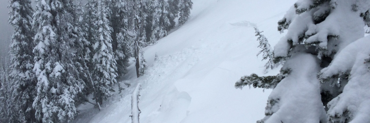
We received several reports of triggered avalanche activity in the Bitterroot range near Lost Horse and Hoodoo Pass and we remotely triggered several wind and storm snow slabs in the Rattlesnake yesterday.

The avalanche danger is HIGH on terrain steeper than 35 degrees.

We plan to get again today and Dudley will issue the regular advisory tomorrow morning.

READ FULL ADVISORY  

Problem 1 - Sensitive wind slabs

  • TYPE

    wind-slabs

    Wind Slabs

    Release of a cohesive layer of snow (a slab) formed by the wind.  Wind typically erodes snow from the upwind sides of terrain features and deposits snow on the downwind side.  Wind slabs are often smooth and rounded and sometimes sound hollow, and can range from soft to hard. Wind slabs that form over a persistent weak layer (surface hoar, depth hoar, or near-surface facets) may be termed Persistent Slabs or may develop into Persistent Slabs.

  • SIZE

    3-4

    1-2 (Small-Large)

    The potential size of avalanche resulting from this problem.

  • LIKELIHOOD

    Likelihood-7

    Very Likely

    The likelihood of an avalanche resulting from this problem.

  • ADDED DANGER

    Increased Slope Danger

    Increased/Added Danger

    There is an increased risk of avalanches on these slopes:

    N - North
    NE - Northeast
    E - East
    SE - Southeast
    S - South
    SW - Southwest
    NW - Northwest

Fresh wind slabs developed on any leeward terrain including areas that have been cross loaded and further down slope where eddy winds moved snow.

Problem 2 - Heavy storm snow

  • TYPE

    storm-slabs

    Storm Slabs

    Release of a soft cohesive layer (a slab) of new snow which breaks within the storm snow or on the old snow surface. Storm-slab problems typically last between a few hours and few days. Storm-slabs that form over a persistent weak layer (surface hoar, depth hoar, or near-surface facets) may be termed Persistent Slabs or may develop into Persistent Slabs.

  • SIZE

    3-4

    1-2 (Small-Large)

    The potential size of avalanche resulting from this problem.

  • LIKELIHOOD

    Likelihood-7

    Very Likely

    The likelihood of an avalanche resulting from this problem.

  • ADDED DANGER

    Increased Slope Danger

    Increased/Added Danger

    There is an increased risk of avalanches on these slopes:

    N - North
    NE - Northeast
    E - East
    SE - Southeast
    S - South
    SW - Southwest
    W - West
    NW - Northwest

Heavy snow from the past 48 hours was deposited on a weak layer of facets that formed during the clear weather several days ago.  This weakness is found throughout the advisory area.

VIDEO

Solstice avalanche conditions

FORECAST & OUTLOOK

The storm has exited the area and we can expect a few showers today as high pressure begins to build.

The avalanche danger will slowly improve over the next few days.

This information is the sole responsibility of the Forest Service and does not apply to operating ski areas. The avalanche danger rating expires at midnight tonight but the information can help you make a more informed decision regarding travel in avalanche terrain for the next few days.

Our advisory area includes National Forest System lands in the Bitterroot Mountains from Lost Trail Pass north to Granite Pass, the Rattlesnake Mountains north of Missoula and the Southern Swan and Mission Mountains near Seeley Lake, MT. Avalanche information for the Lookout Pass/St. Regis Basin area is available from the Idaho Panhandle Avalanche Center.