
The avalanche danger in the west central Montana backcounty is moderate. Human triggered avalanches are possible on slopes steeper than 30 degrees above 5000 feet. The storm snow from Sunday and Monday has settled, but snow stability tests around the region are showing lingering weaknesses.
Good morning! This is Dudley Improta with the West Central Montana Avalanche Center’s advisory for January 9, 2015. This danger rating does not apply to operating ski areas, expires at midnight tonight (Jan.9) and is the responsibility of the U.S. Forest Service.
Weather and Snowpack Discussion
This morning southeast and east mountain winds are blowing at 5 mph and gusting to 15 mph. Temperatures above 6000 feet are ranging from 11 to 18 degrees F. There was a trace of snow overnight; today should be generally sunny.
Just because I’m calling moderate avalanche danger this morning there is no reason to think you can’t trigger an avalanche on a 30 degree plus slope. Snotels in the area have shown significant settlement and, earlier in the week, we had warmer temperatures at elevations above 5000 feet. These are good signs of stability; but snow stability tests continue to show weakness in the snow.
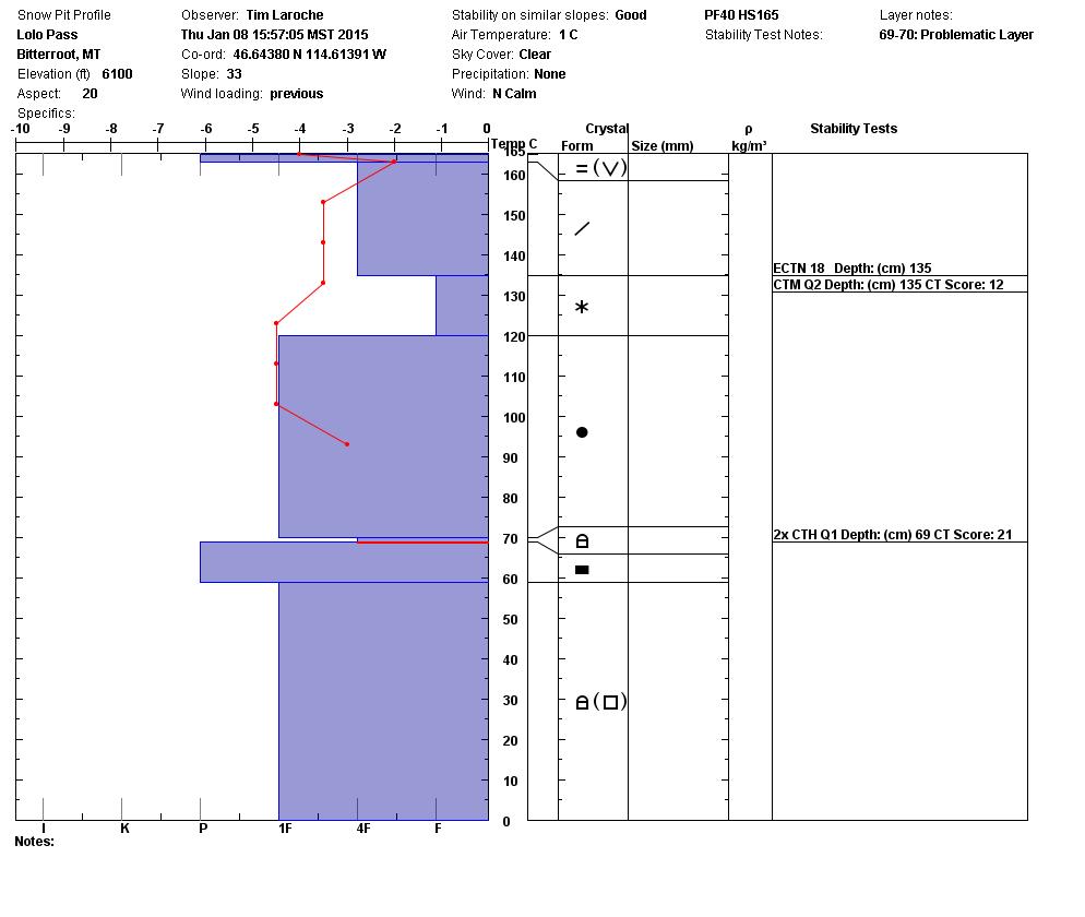
Tim and Steve covered some ground yesterday near Lolo Pass. They rode into the Brushy Fork and then, north of Highway 12, to the top of Crystal Theatre. Their snow tests (profile below) showed the early season facets from December still failing. Five Valleys Backcountry Ski Patrol had similar results in this area on Wednesday. Besides the old facets failing, the Patrol also got the recent storm snow to fail (see Public obs).
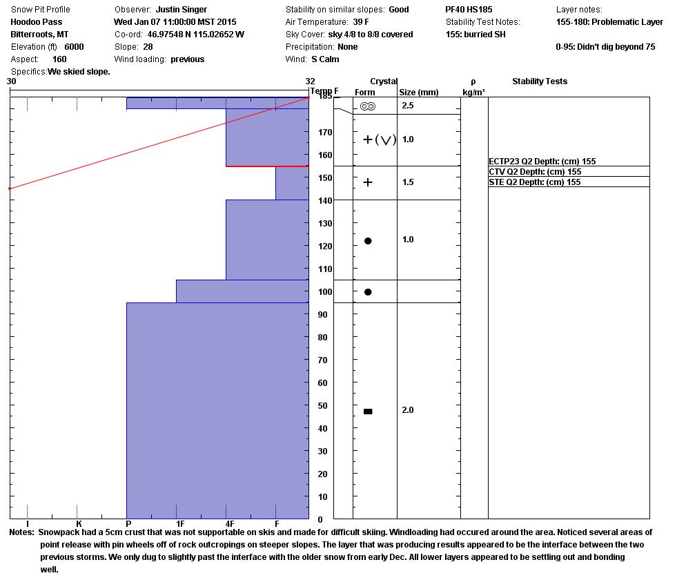
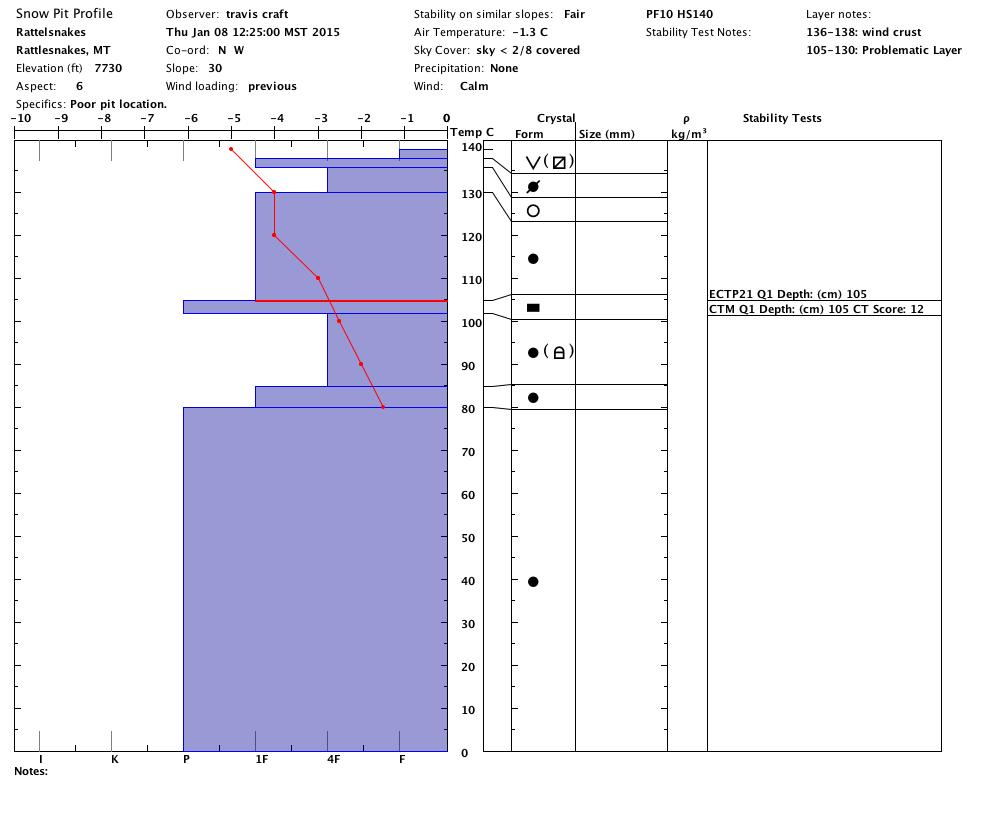
The recent storm snow failed in tests at Hoodoo Pass on Wednesday and in the Rattlesnakes yesterday (profiles below). Observers at Hoodoo Pass had the storm snow fail easily in CT’s and propagate with high strength in ECT’s. In the Rattlesnakes, between 7900 and 7800 ft., Travis and I had ECT propagation of 12 and 21 on slopes with northerly aspects.
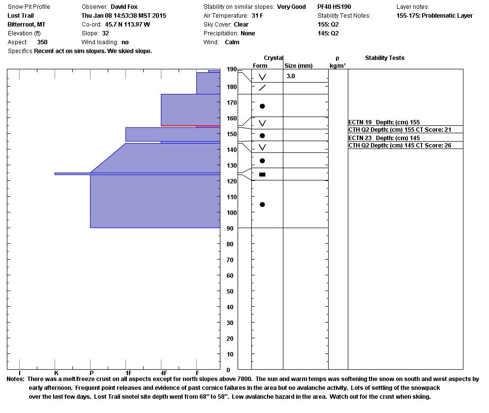
Observers near the Lost Trail area were seeing the least reactive snowpack with generally stable results in their tests (profile below). Snotels near LT show nearly 8 to 9 inches of settlement since Monday.
Bottom Line
So, we are only seeing some recent activity from a few days ago, related to the storm that ended Monday. Snotels are showing significant snow settlement. There is no whumphing or cracking. Temperatures warmed up, then cooled, and there has been no load since Monday. But, stability tests from different areas are all showing consistent weaknesses in the snowpack. If you choose to recreate on a steep slope, dig a quick pit and check it out; and as always, never expose more than one skier, sledder or snowboarder to avalanche hazard at any one time.
Avalanche & Weather Outlook
Looks like a little sun today with a weak high pressure in place. 4 to 8 inches of snow is forecast above 5000 feet on Saturday and Sunday. Note the surface temperature gradients in the snow profiles; this new snow will be deposited on faceted snow. I would expect the avalanche danger to stay the same for now.
Steve will issue the next regularly scheduled advisory Tuesday, January 13.
We appreciate public observations.
Ride and ski safe; have a great weekend.


