Posted:
Jan 16, 2015 @ 7:00 am

In the west central Montana backcountry above 6000 feet, the avalanche danger is MODERATE on wind loaded terrain steeper than 35 degrees. Natural avalanches are unlikely, human triggered avalanches are possible. Expect the avalanche danger to rapidly increase as new snow and high winds move into the area.

At all other mountain locations the avalanche danger is LOW. Natural and human triggered avalanches are unlikely. It is still possible to find unstable snow in isolated areas so remember that low avalanche danger does NOT mean no avalanche danger.

Hello! This is Steve Karkanen with the West Central Montana Avalanche Center’s backcountry avalanche advisory for January 16, 2015. This information is the responsibility of the Forest Service and does not apply to operating ski areas. The danger rating expires at midnight tonight.

Mountain temperatures are in the upper 20’s with south winds at Point Six in the 20’s gusting to 27. At Deer Point near Darby winds are from the south at 20 mph with gusts to 33 . No precipitation has been recorded in the past few days.

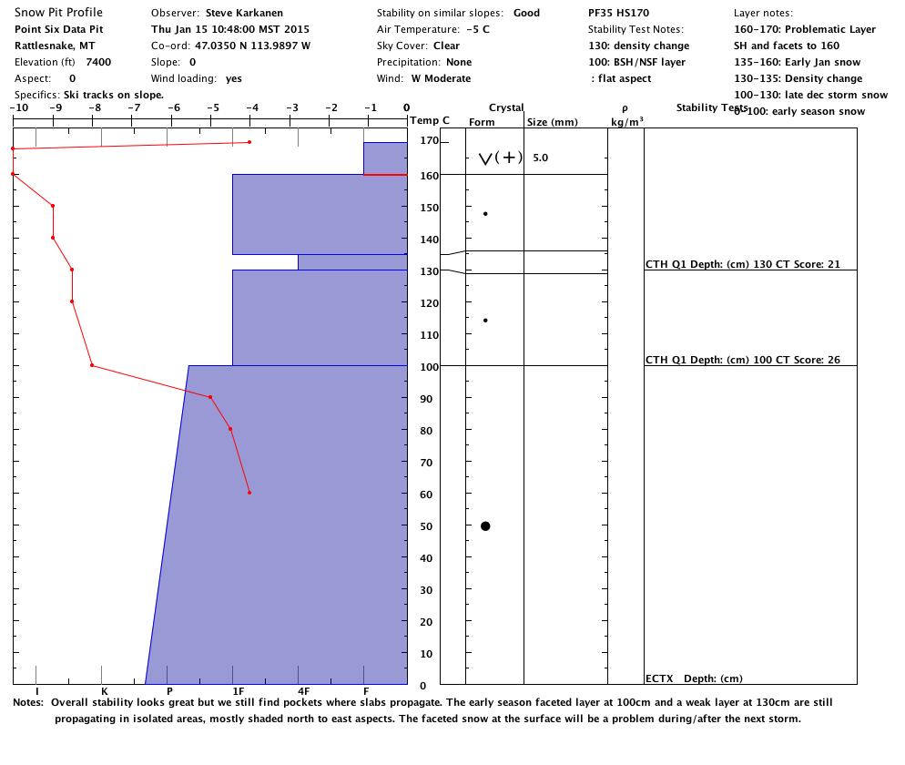
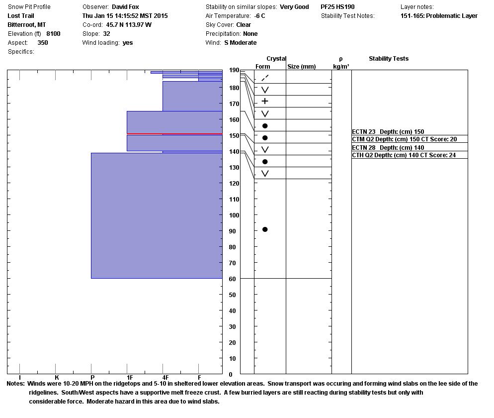
Our observers report mostly stable conditions with the primary concern focusing on how the current surface condition will affect stability.  In some locations we’re finding evidence of weak layers failing with moderate strength. In isolated areas, we’re still getting slabs to propagate in extended column testing (see this week’s video).

While the overall snowpack appears to have settled and strengthened, there are still areas where it may be possible to trigger a deeper slab with serious consequences.  The only way to determine if the slope you want to recreate on has this instability is to dig into it.

During the clear weather this week, the surface of our snowpack weakened and will be the next main problem to be aware of.  New snow and high winds will rapidly increase the avalanche danger.

I’ll issue the next regular advisory next Tuesday, January 20th.


READ FULL ADVISORY  

Problem 1 - Sensitive wind slabs

  • TYPE

    wind-slabs

    Wind Slabs

    Release of a cohesive layer of snow (a slab) formed by the wind.  Wind typically erodes snow from the upwind sides of terrain features and deposits snow on the downwind side.  Wind slabs are often smooth and rounded and sometimes sound hollow, and can range from soft to hard. Wind slabs that form over a persistent weak layer (surface hoar, depth hoar, or near-surface facets) may be termed Persistent Slabs or may develop into Persistent Slabs.

  • SIZE

    3-4

    1-2 (Small-Large)

    The potential size of avalanche resulting from this problem.

  • LIKELIHOOD

    Likelihood-3

    Possible

    The likelihood of an avalanche resulting from this problem.

  • ADDED DANGER

    Increased Slope Danger

    Increased/Added Danger

    There is an increased risk of avalanches on these slopes:

    NE - Northeast
    E - East
    SE - Southeast

Wind speeds have increased in the past 24 hours and it is moving much of the available snow onto lee aspects. The good thing about the wind is that it can destroy the surface hoar crystals wherever it reaches the surface.

Problem 2 - Persistent weak layers

  • TYPE

    persistent-slabs

    Persistent Slabs

    Release of a cohesive layer of soft to hard snow (a slab) in the middle to upper snowpack, when the bond to an underlying persistent weak layer breaks.  Persistent layers include: surface hoar, depth hoar, near-surface facets, or faceted snow. Persistent weak layers can continue to produce avalanches for days, weeks or even months, making them especially dangerous and tricky. As additional snow and wind events build a thicker slab on top of the persistent weak layer, this avalanche problem may develop into a Persistent, Deep-Slab.

  • SIZE

    3-4

    1-2 (Small-Large)

    The potential size of avalanche resulting from this problem.

  • LIKELIHOOD

    Likelihood-2

    Unlikely/Possible

    The likelihood of an avalanche resulting from this problem.

  • ADDED DANGER

    Increased Slope Danger

    Increased/Added Danger

    There is an increased risk of avalanches on these slopes:

    N - North
    NE - Northeast
    E - East

We still find that the weak layers which formed in December are demonstrating potential for failure on some slopes.  The only way to know if the slope you plan to play on has weak layers is to dig into it and do a stability test.  If your tests show crisp, flat failure surfaces or if you have propagation in Extended Column Tests, don’t trust it.  It could save your life.

VIDEO

January 15, 2015 NE aspect of Pt Six in the Rattlesnake. Winds are picking up and moving snow. Mostly stable snow with areas of concern as described herein.

Photos from January 15, 2015.

FORECAST & OUTLOOK

The Missoula Weather Service Office is forecasting moderate and persistent snowfall today through Saturday. Up to a foot of snow is expected for the Bitterroot range with less snow to the east. Winds are expected to be in the 60mph range out of the west southwest so expect a lot of moving snow and heavily loaded lee terrain.

This information is the sole responsibility of the Forest Service and does not apply to operating ski areas. The avalanche danger rating expires at midnight tonight but the information can help you make a more informed decision regarding travel in avalanche terrain for the next few days.

Our advisory area includes National Forest System lands in the Bitterroot Mountains from Lost Trail Pass north to Granite Pass, the Rattlesnake Mountains north of Missoula and the Southern Swan and Mission Mountains near Seeley Lake, MT. Avalanche information for the Lookout Pass/St. Regis Basin area is available from the Idaho Panhandle Avalanche Center.