Posted:
Mar 6, 2015 @ 6:29 am

The avalanche danger is rated at low in the west central Montana backcountry. It may be possible to trigger a small wind slab or loose snow avalanche on steep terrain (>35 degrees). Larger natural or triggered avalanches are unlikely, not impossible, unlikely. There is always some chance of triggering an avalanche if you recreate or travel on slopes 35 degrees and steeper.

Good morning, this is Dudley Improta with the West Central Montana Avalanche Center’s advisory for March 6, 2015. The danger rating does not apply to operating ski areas and expires at midnight tonight (3/6/15).

Weather and Snowpack

Mountain winds are generally out of the west this  morning. Up on Point 6 (near 8000 ft.) the winds are whipping in the 25 mph range and gusting into the 3o’s. Temperatures above 6ooo feet are in the mid to high 20’s F, with a couple of spots in the northern part of the advisory area right at freezing. It looks like a nice day today and above normal temperatures for the weekend. College students and fishing guides will be back in their flip-flops; maybe we’ll have to act like it’s winter this summer.

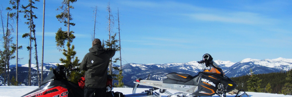
Steve and I took a ride around the Lolo Pass area yesterday.  There was actually 3-4 inches of new snow that made for good sledding. The snowpack in the Lolo Pass area was bomber.

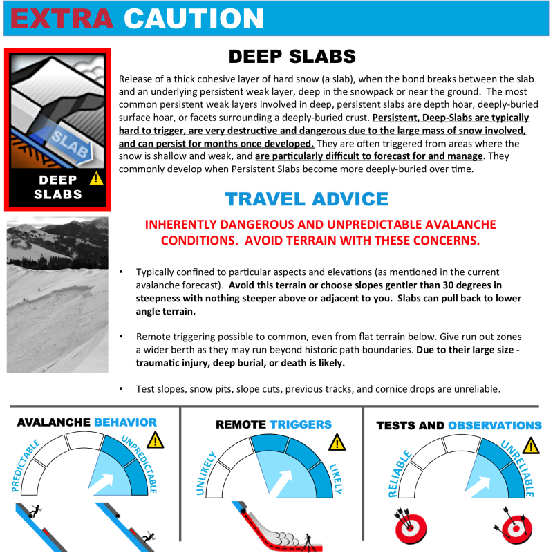
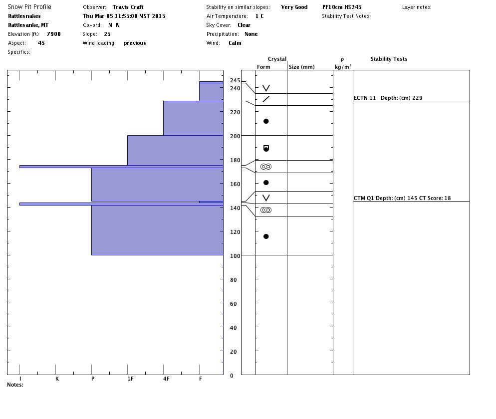
Travis and Tim went into the Rattlesnakes (Rattlesnakes snowpit below) and could not get the deep persistent layer, we’ve been talking about for a month, to propagate. I am going to mention it below as a problem just because it has hung around so long. There is a very low chance of triggering this slab. You could increase your chances of triggering it if you don’t ride or ski one at a time in steep, open bowls with shaded northerly aspects. Seriously, I would dig a little more than a meter down to look for this weakness in steep, shady terrain.

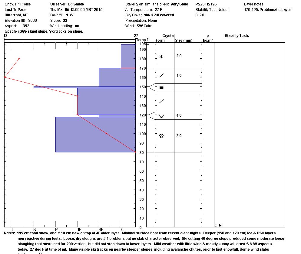
Ed Snook and Geoff Fast were out and about in the Lost Trail Area (LT snowpit below). They noted 4 inches of new snow that sluffed, when ski cut, on  very steep slopes (40 degrees). There were indications that small wind slabs were lurking on steep slopes as well.

Weather and Snow Outlook

West central Montana will see mild and dry conditions into next week. A high pressure ridge looks to be well entrenched. Temperatures are expected to gradually increase over the next couple of days. At least we won’t have rapid warming. There might the possibility of wet loose slides on sun-exposed slopes as this warming occurs.

If you get out and want to send us any snow observations use our public observation form or simply send us an e-mail at [email protected] .

Travis Craft will post the next regularly scheduled advisory Tuesday,  March 10 .

Ride and ski safe, have a great weekend.


READ FULL ADVISORY  

Problem 1 - wind slabs

  • TYPE

    wind-slabs

    Wind Slabs

    Release of a cohesive layer of snow (a slab) formed by the wind.  Wind typically erodes snow from the upwind sides of terrain features and deposits snow on the downwind side.  Wind slabs are often smooth and rounded and sometimes sound hollow, and can range from soft to hard. Wind slabs that form over a persistent weak layer (surface hoar, depth hoar, or near-surface facets) may be termed Persistent Slabs or may develop into Persistent Slabs.

  • SIZE

    2-3

    1 (Small)

    The potential size of avalanche resulting from this problem.

  • LIKELIHOOD

    Likelihood-2

    Unlikely/Possible

    The likelihood of an avalanche resulting from this problem.

Remnant wind slabs may exist on steep  slopes (>35 degrees). Winds came from all directions over the week so any steep aspect is suspect.

Problem 2 - loose snow

  • TYPE

    loose-wet

    Loose Wet

    Release of wet unconsolidated snow or slush. These avalanches typically occur within layers of wet snow near the surface of the snowpack, but they may quickly gouge into lower snowpack layers. Like Loose-Dry Avalanches,they start at a point and entrain snow as they move downhill, forming a fan-shaped avalanche. They generally move slowly, but can contain enough mass to cause significant damage to trees, cars or buildings. Other names for loose-wet avalanches include point-release avalanches or sluffs. Loose-wet avalanches can trigger slab avalanches that break into deeper snow layers.

  • SIZE

    2-3

    1 (Small)

    The potential size of avalanche resulting from this problem.

  • LIKELIHOOD

    Likelihood-2

    Unlikely/Possible

    The likelihood of an avalanche resulting from this problem.

Triggered, loose snow avalanches were observed in the Lost Trail area yesterday. They were small and manageable. There might tbe the possibility of wet loose slides on sun-exposed slopes as temperatures warm over the next few days.

Problem 3 - deep persistent slab

  • TYPE

    deep-persistent-slabs

    Deep Persistent Slabs

    Release of a thick cohesive layer of hard snow (a slab), when the bond breaks between the slab and an underlying persistent weak layer, deep in the snowpack or near the ground.  The most common persistent weak layers involved in deep, persistent slabs are depth hoar, deeply-buried surface hoar, or facets surrounding a deeply-buried crust. Persistent, Deep-Slabs are typically hard to trigger, are very destructive and dangerous due to the large mass of snow involved, and can persist for months once developed. They are often triggered from areas where the snow is shallow and weak, and are particularly difficult to forecast for and manage. They commonly develop when Persistent Slabs become more deeply-buried over time.

  • SIZE

    4-5

    2 (Large)

    The potential size of avalanche resulting from this problem.

  • LIKELIHOOD

    Likelihood-1

    Unlikely

    The likelihood of an avalanche resulting from this problem.

  • ADDED DANGER

    Increased Slope Danger

    Increased/Added Danger

    There is an increased risk of avalanches on these slopes:

    N - North
    NE - Northeast

  • IMAGE

We have been watching a weak layer about 3 feet into the snowpack for a month. It didn’t propagate in stability tests yesterday,  but it did this past weekend.  I feel compelled to mention it. Actually, I would dig a little over a meter into the snow and look for it,  if I was skiing or riding  big, shaded, steep terrain.

Snowpits and pics from yesterday 3/5/15 .

FORECAST & OUTLOOK

West central Montana will see mild and dry conditions into next week. A high pressure ridge looks to be well  entrenched. Temperatures are expected to gradually increase over the next couple of days. At least we won’t have rapid warming. There might tbe the possibility of wet loose slides on sun-exposed slopes as this warming occurs.

This information is the sole responsibility of the Forest Service and does not apply to operating ski areas. The avalanche danger rating expires at midnight tonight but the information can help you make a more informed decision regarding travel in avalanche terrain for the next few days.

Our advisory area includes National Forest System lands in the Bitterroot Mountains from Lost Trail Pass north to Granite Pass, the Rattlesnake Mountains north of Missoula and the Southern Swan and Mission Mountains near Seeley Lake, MT. Avalanche information for the Lookout Pass/St. Regis Basin area is available from the Idaho Panhandle Avalanche Center.