Posted:
Mar 17, 2015 @ 6:39 am

The avalanche danger is LOW at all mountain locations in west central Montana. Natural and human triggered avalanches are unlikely. Conditions are generally safe but there are isolated places where it is possible to trigger an avalanche.

Good morning backcountry skiers and riders! This is Steve Karkanen with the West Central Montana Avalanche Center’s backcountry avalanche advisory for Tuesday March 17, 2015. This information is the responsibility of the Forest Service and does not apply to operating ski areas. This is the final Tuesday advisory for the 2014/15 winter.

Mountain temperatures are at or just above freezing this morning with a southerly wind gusting into the twenties at Point Six. Most SNOTEL stations received about a tenth of an inch of rain in the past 24 hours.

Western Montana has been under the influence of a fast moving series of rain showers from the Pacific. All mountain locations received heavy rain Sunday which tapered to intermittent rain shower activity during the past 48 hours.

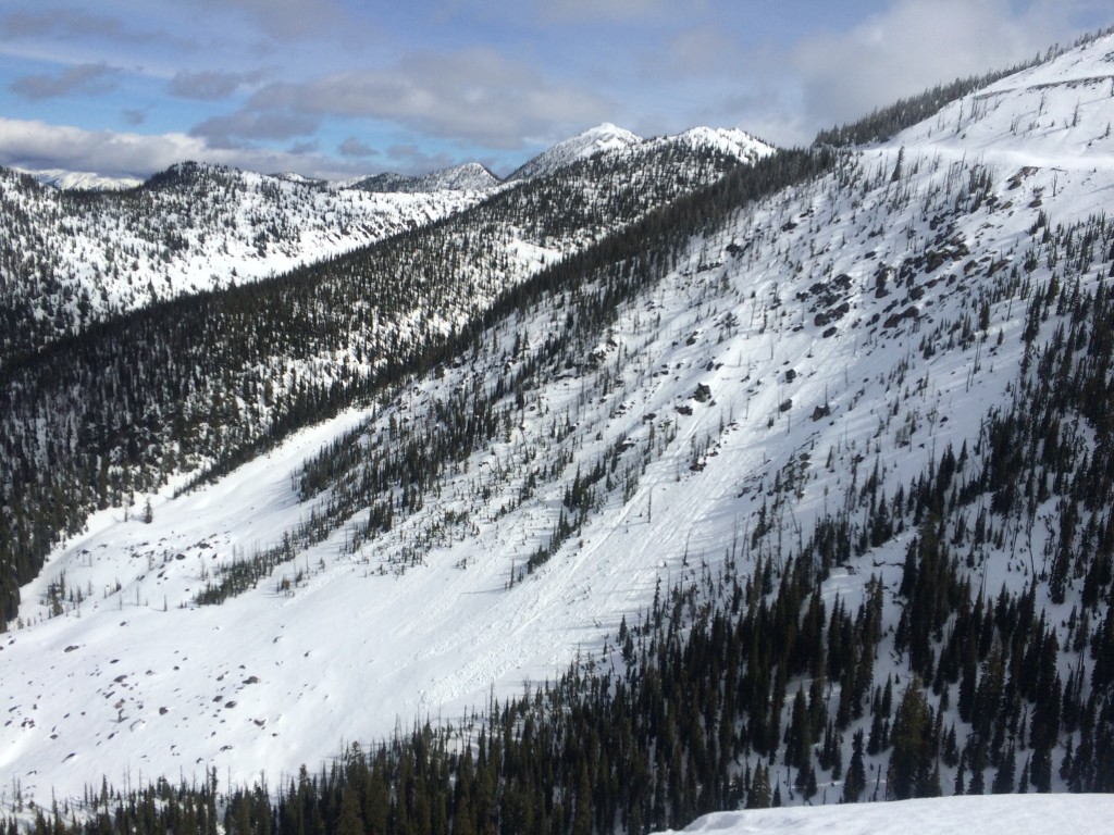
This rain further deteriorated an already thin snowpack at the mid-elevations and saturated the higher elevation snowpack. Most locations below 8000 feet have already been through rain on snow events not to mention weeks of melt-freeze cycles so the snowpack handled the heavy rain pretty well. We did see evidence of wet loose snow avalanches on very steep west facing terrain that was previously wind loaded from the north.

As temperatures cool with the frontal passage today I expect this snow to lock up tight.


This will be the final Tuesday advisory for this winter. We plan to issue 2 more regular Friday advisories and close down soon thereafter.  Logan King will report on avalanche conditions this Friday.

READ FULL ADVISORY  

Problem 1 - Loose Wet Snow

  • TYPE

    loose-wet

    Loose Wet

    Release of wet unconsolidated snow or slush. These avalanches typically occur within layers of wet snow near the surface of the snowpack, but they may quickly gouge into lower snowpack layers. Like Loose-Dry Avalanches,they start at a point and entrain snow as they move downhill, forming a fan-shaped avalanche. They generally move slowly, but can contain enough mass to cause significant damage to trees, cars or buildings. Other names for loose-wet avalanches include point-release avalanches or sluffs. Loose-wet avalanches can trigger slab avalanches that break into deeper snow layers.

  • SIZE

    3-4

    1-2 (Small-Large)

    The potential size of avalanche resulting from this problem.

  • LIKELIHOOD

    Likelihood-2

    Unlikely/Possible

    The likelihood of an avalanche resulting from this problem.

  • ADDED DANGER

    Increased Slope Danger

    Increased/Added Danger

    There is an increased risk of avalanches on these slopes:

    N - North
    NE - Northeast
    E - East
    SE - Southeast
    S - South
    SW - Southwest
    W - West
    NW - Northwest

When you start seeing rollers and pinwheels or are punching through to your boot tops it’s time to move onto a more shaded aspect.

Problem 2 - Weakened Cornices

  • TYPE

    cornices

    Cornices / Cornice Fall

    Release of an overhanging mass of snow that forms as the wind moves snow over a sharp terrain feature, such as a ridge, and deposits snow on the down-wind side. They range from small wind lips of soft snow to large overhangs of hard snow that are 30 feet (~10 meters) or taller. They can break off the terrain suddenly and pull back onto the ridge top and catch people by surprise even on the flat ground above the slope. Even small cornices can have enough mass to be destructive and deadly. Cornice fall can entrain loose surface snow or trigger slab avalanches.

  • SIZE

    3-4

    1-2 (Small-Large)

    The potential size of avalanche resulting from this problem.

  • LIKELIHOOD

    Likelihood-3

    Possible

    The likelihood of an avalanche resulting from this problem.

  • ADDED DANGER

    Increased Slope Danger

    Increased/Added Danger

    There is an increased risk of avalanches on these slopes:

    NE - Northeast
    E - East

Cornices have been weakened by the warmer temperatures and infusion of water and cannot be trusted. Give them a wide berth.

Photos from Monday March 16, 2015.

FORECAST & OUTLOOK

The Missoula Weather Service Office is forecasting continued rain shower activity turning to snow at mountain pass elevations later today with an increase in intensity Wednesday morning. Not much snow is expected however strong winds will move anything that does fall so lee terrain will be the most likely place to trigger a small slide.

This information is the sole responsibility of the Forest Service and does not apply to operating ski areas. The avalanche danger rating expires at midnight tonight but the information can help you make a more informed decision regarding travel in avalanche terrain for the next few days.

Our advisory area includes National Forest System lands in the Bitterroot Mountains from Lost Trail Pass north to Granite Pass, the Rattlesnake Mountains north of Missoula and the Southern Swan and Mission Mountains near Seeley Lake, MT. Avalanche information for the Lookout Pass/St. Regis Basin area is available from the Idaho Panhandle Avalanche Center.