Posted:
Jan 23, 2016 @ 6:56 am

The avalanche danger is rated CONSIDERABLE in the southern Swan and southern Mission ranges. Human-triggered avalanches are likely.  Careful snowpack evaluation, cautious route-finding and conservative decision making are essential.  The rest of the advisory area (the Rattlesnake and entire Bitterroot range) the danger rating is moderate. Human triggered avalanches are possible.

Good morning, this is Travis Craft with the West Central Montana Avalanche Center’s avalanche advisory for January 23, 2016. This danger rating does not apply to operating ski areas, expires at midnight tonight and is the sole responsibility of the U.S. Forest Service.

Weather and Snowpack

The temperatures are in the mid to upper 20’s this morning.  No new snow fell overnight.  Winds are 13 mph gusting to 17 mph out of the SSW in the Bitterroot.  In the northern portion of the region winds are 10 mph gusting to 16 mph out of the SSW.

The southern Swan and southern Missions have a considerable  avalanche danger rating. The primary concern is the persistent weak layer of near surface facets that Logan and Tim found on Wednesday.  This layer is very reactive in our pit tests.  We are getting reports of shooting cracks and natural avalanche activity, this is bullseye data of instability.  A storm slab is the second problem.  The large amount of new snow from the past couple of days needs time to settle.  The last concern is that high winds from the last two days created wind slabs on leeward terrain.  So, with these three concerns the avalanche problem is complex and means that careful snowpack evaluation,  cautious route finding, and conservative decision making are needed for travel in avalanche terrain today.

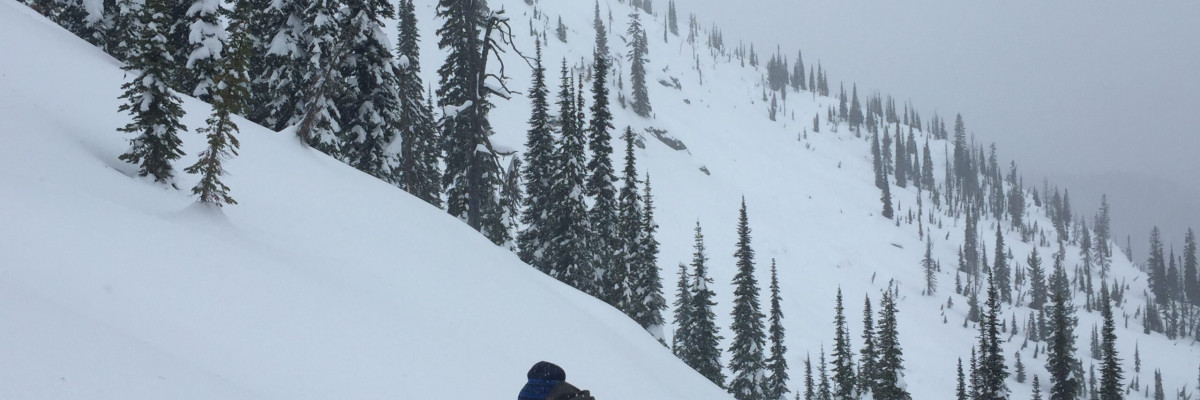
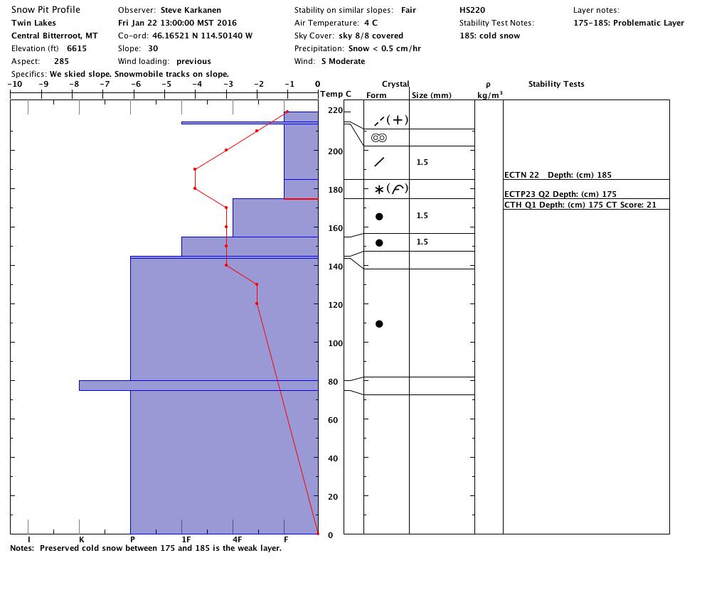
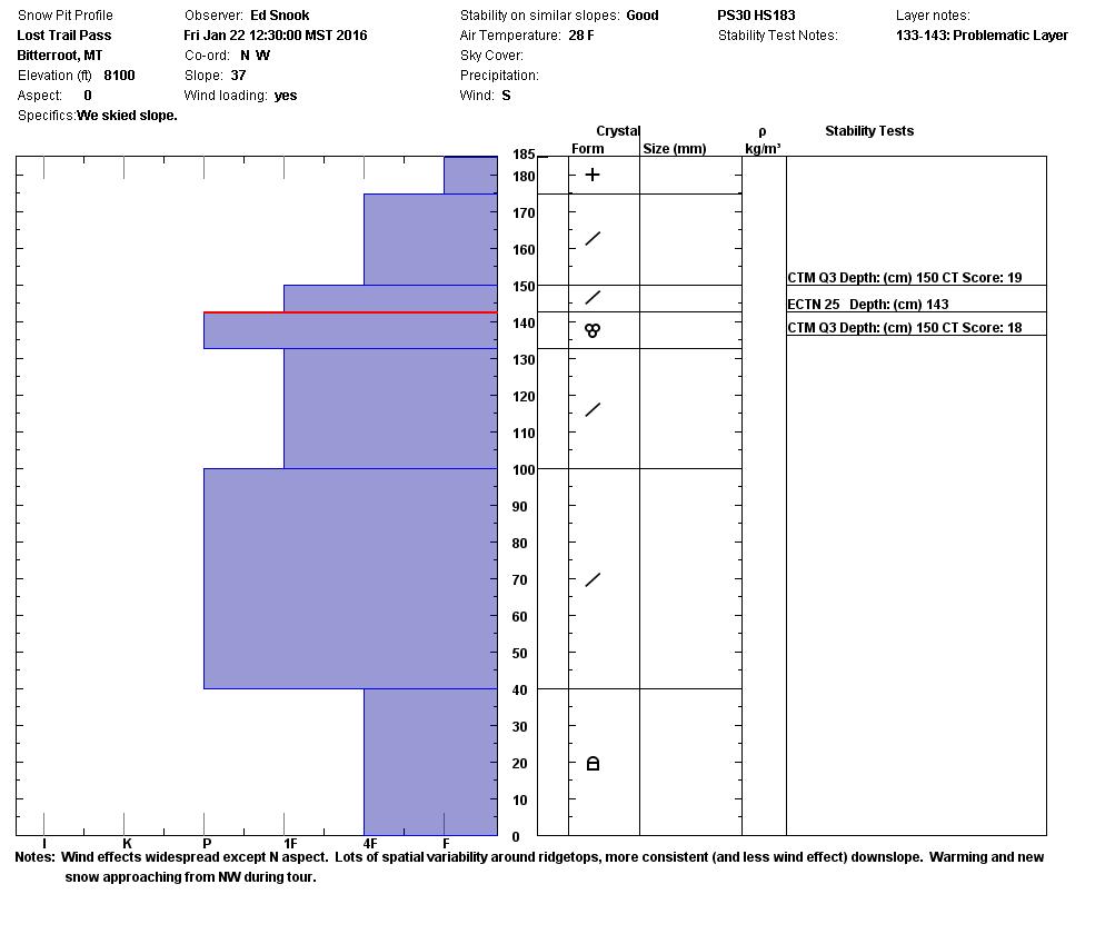
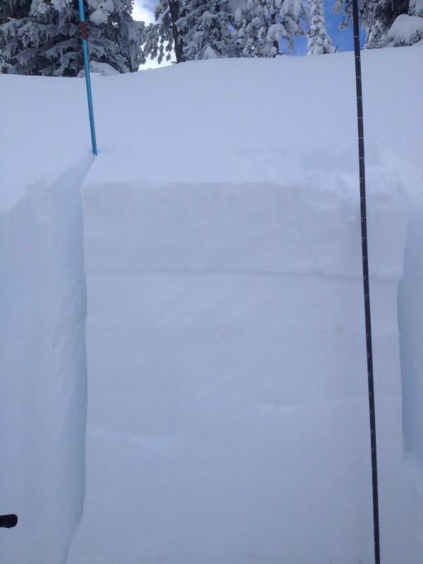
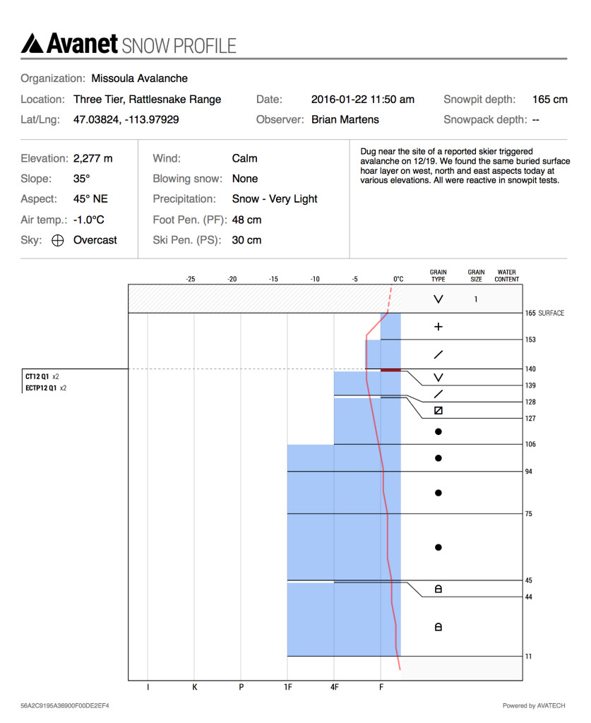
The Rattlesnake and Bitterroot ranges have a moderate danger rating.  The main problem Steve and I saw in the central Bitterroot was the storm slab.  It was failing on the upside down cold snow from the beginning of the storm cycle 6 days ago.  This was seen by Ed in the southern Bitterroot and Brian and Josh in the Rattlesnake.  This layer varies in depth from 20cm to 60cm depending on storm totals (pit01pit02pit03).  To find this interface dig a pit and see if it propagates in your ECT.  The second avalanche problem are the wind slabs which have formed in the region from the high winds over the past few days.  Be aware of leeward slopes.  This means human triggered avalanches are possible and evaluate snow and terrain carefully.

Weather and Avalanche Forecast 

A weak disturbance is expected to enter our region today and bring with it precipitation and strong winds that will last until Sunday night.  The mountains should pick up several inches of snow.  This addition of new snow and wind will increase the avalanche hazard.  If you are out traveling in avalanche terrain during this weather remember conditions can change quickly and pay attention to any bullseye data (shooting cracks, sudden collapses, and recent avalanches).  Bullseye data are signs of instability.

Ski and ride safe.  I will issue the next advisory on Tuesday.


READ FULL ADVISORY  

Problem 1 - Storm Slabs

  • TYPE

    storm-slabs

    Storm Slabs

    Release of a soft cohesive layer (a slab) of new snow which breaks within the storm snow or on the old snow surface. Storm-slab problems typically last between a few hours and few days. Storm-slabs that form over a persistent weak layer (surface hoar, depth hoar, or near-surface facets) may be termed Persistent Slabs or may develop into Persistent Slabs.

  • SIZE

    3-4

    1-2 (Small-Large)

    The potential size of avalanche resulting from this problem.

  • LIKELIHOOD

    Likelihood-3

    Possible

    The likelihood of an avalanche resulting from this problem.

  • IMAGE

Strom Slabs failing on preserved cold snow interface.

Problem 2 - Persistent Slabs

  • TYPE

    persistent-slabs

    Persistent Slabs

    Release of a cohesive layer of soft to hard snow (a slab) in the middle to upper snowpack, when the bond to an underlying persistent weak layer breaks.  Persistent layers include: surface hoar, depth hoar, near-surface facets, or faceted snow. Persistent weak layers can continue to produce avalanches for days, weeks or even months, making them especially dangerous and tricky. As additional snow and wind events build a thicker slab on top of the persistent weak layer, this avalanche problem may develop into a Persistent, Deep-Slab.

  • SIZE

    4-5

    2 (Large)

    The potential size of avalanche resulting from this problem.

  • LIKELIHOOD

    Likelihood-3

    Possible

    The likelihood of an avalanche resulting from this problem.

  • ADDED DANGER

    Increased Slope Danger

    Increased/Added Danger

    There is an increased risk of avalanches on these slopes:

    SE - Southeast
    S - South
    SW - Southwest
    W - West

Melt Freeze crust or areas that have had diurnal recrystallization producing near surface facets.  This is found in the northern portion of our advisory area.

Problem 3 - Wind Slabs

  • TYPE

    wind-slabs

    Wind Slabs

    Release of a cohesive layer of snow (a slab) formed by the wind.  Wind typically erodes snow from the upwind sides of terrain features and deposits snow on the downwind side.  Wind slabs are often smooth and rounded and sometimes sound hollow, and can range from soft to hard. Wind slabs that form over a persistent weak layer (surface hoar, depth hoar, or near-surface facets) may be termed Persistent Slabs or may develop into Persistent Slabs.

  • SIZE

    3-4

    1-2 (Small-Large)

    The potential size of avalanche resulting from this problem.

  • LIKELIHOOD

    Likelihood-3

    Possible

    The likelihood of an avalanche resulting from this problem.

There is plenty of snow around for transport.  Be cautious of leeward terrain.

Pits and Photos form 01/22/2016

FORECAST & OUTLOOK

New loading and Wind

This information is the sole responsibility of the Forest Service and does not apply to operating ski areas. The avalanche danger rating expires at midnight tonight but the information can help you make a more informed decision regarding travel in avalanche terrain for the next few days.

Our advisory area includes National Forest System lands in the Bitterroot Mountains from Lost Trail Pass north to Granite Pass, the Rattlesnake Mountains north of Missoula and the Southern Swan and Mission Mountains near Seeley Lake, MT. Avalanche information for the Lookout Pass/St. Regis Basin area is available from the Idaho Panhandle Avalanche Center.