Posted:
Jan 28, 2016 @ 6:22 am

The current avalanche danger is MODERATE for the west central Montana backcountry. Human triggered avalanches are possible, natural avalanches are unlikely.  Heightened avalanche conditions exist in isolated terrain.  

Good morning, this is Logan King with the West Central Montana Avalanche Center’s avalanche advisory for Thursday, January 28th 2016.  The danger rating does not apply to operating ski areas, expires at midnight tonight and is the sole responsibility of the U.S. Forest Service.

Weather and Snowpack

Over the past 24 hours the advisory area has seen a trace to two inches of heavy snow bringing .3-.5 inches of SWE to the majority of the advisory area. Mountain temps are currently in the mid thirties and the majority of sites did not drop below freezing overnight. Currently winds are 13-20mph with gusts of 20-30mph out of the SW to the SE. 

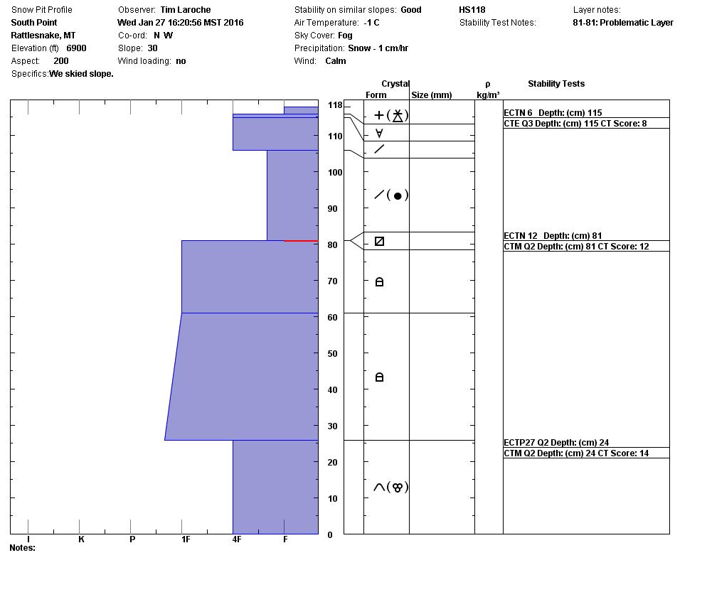
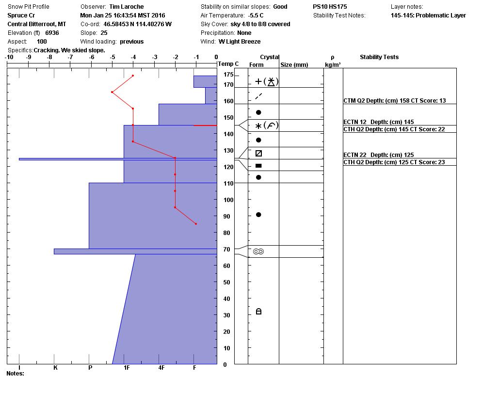
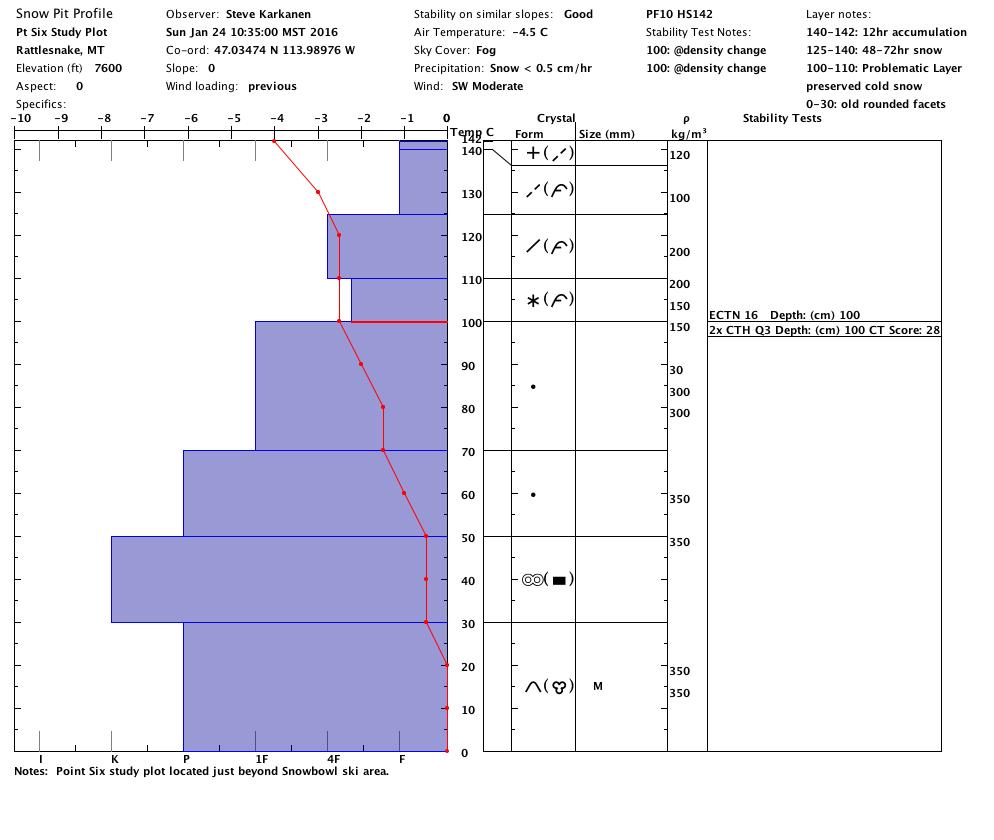
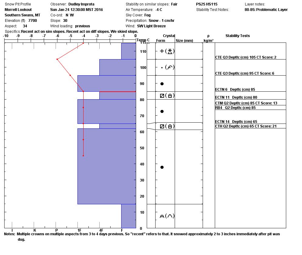
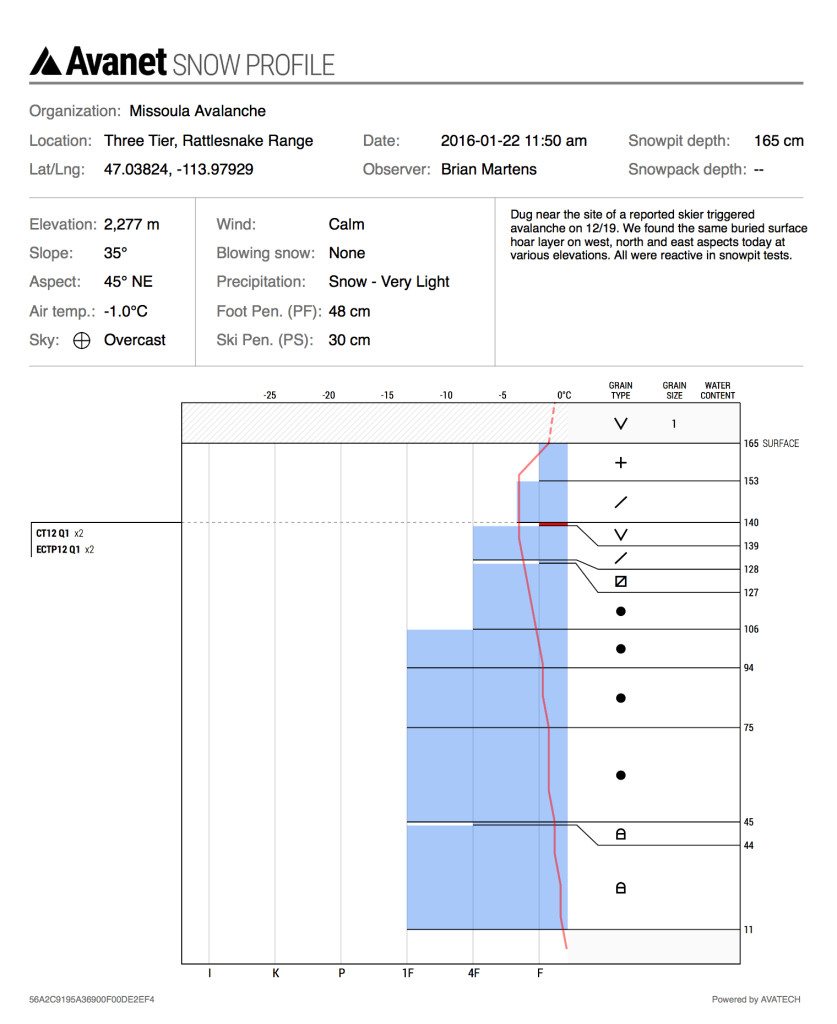
Persistent slabs continue to be the primary avalanche concern. Facets can be found on nearly all aspects and in a multitude of forms. Near Surface facet layers were observed on all aspects yesterday in the Rattlesnake and range from 2mm thick to 10 cm thick (pit). Buried surface hoar has also been seen in the advisory area, lastly Tim and I found depth hoar that propagated in shallower areas yesterday as well. The facet layers are not always reactive but are widespread and will be stressed with the new load so conservative decision making as well as identifying where the facets are will be critical today.

The second avalanche concern are wind slabs, strong and irregular winds created windslabs throughout the advisory area and they have been periodically reactive. We received a report of a human triggered windslab on Tuesday in a popular riding area north of Lincoln, MT. All leeward terrain has the potential to be harboring a windslab, stay keyed into signs of wind affected snow.

The third avalanche concern is storm slabs, with a heavy wet load of new snow falling on a rime crust and graupel with more to come, the storm slabs will be sensitive until the storm tapers off.

Currently conditions are MODERATE but could easily shift to CONSIDERABLE as more snow accumulates. If you are out in the backcountry today stay aware of conditions as they change and adjust your travel plans accordingly.

Weather and Avalanche Outlook

The forecast is calling for wind and more wet heavy snow with snow levels at about 5,000ft through tonight. There will be a brief break in the wet conditions Friday morning but snow will start to fall again by Friday evening as colder temperatures settle in. As the new snow load increases so will the avalanche danger.

Travis will issue the next advisory on Saturday, January 30th.

READ FULL ADVISORY  

Problem 1 - Persistent Slabs

  • TYPE

    persistent-slabs

    Persistent Slabs

    Release of a cohesive layer of soft to hard snow (a slab) in the middle to upper snowpack, when the bond to an underlying persistent weak layer breaks.  Persistent layers include: surface hoar, depth hoar, near-surface facets, or faceted snow. Persistent weak layers can continue to produce avalanches for days, weeks or even months, making them especially dangerous and tricky. As additional snow and wind events build a thicker slab on top of the persistent weak layer, this avalanche problem may develop into a Persistent, Deep-Slab.

  • SIZE

    3-4

    1-2 (Small-Large)

    The potential size of avalanche resulting from this problem.

  • LIKELIHOOD

    Likelihood-3

    Possible

    The likelihood of an avalanche resulting from this problem.

Facets can be found nearly every where in the advisory area in one form or another. They are not terribly reactive but warrant close attention.

Problem 2 - Wind Slabs

  • TYPE

    wind-slabs

    Wind Slabs

    Release of a cohesive layer of snow (a slab) formed by the wind.  Wind typically erodes snow from the upwind sides of terrain features and deposits snow on the downwind side.  Wind slabs are often smooth and rounded and sometimes sound hollow, and can range from soft to hard. Wind slabs that form over a persistent weak layer (surface hoar, depth hoar, or near-surface facets) may be termed Persistent Slabs or may develop into Persistent Slabs.

  • SIZE

    3-4

    1-2 (Small-Large)

    The potential size of avalanche resulting from this problem.

  • LIKELIHOOD

    Likelihood-3

    Possible

    The likelihood of an avalanche resulting from this problem.

Widespread windslabs throughout the area continue to be problematic. The windslabs are still occasionally failing and we received a report of a human triggered windslab in the northern part of the advisory area.

Problem 3 - Storm Slabs

  • TYPE

    storm-slabs

    Storm Slabs

    Release of a soft cohesive layer (a slab) of new snow which breaks within the storm snow or on the old snow surface. Storm-slab problems typically last between a few hours and few days. Storm-slabs that form over a persistent weak layer (surface hoar, depth hoar, or near-surface facets) may be termed Persistent Slabs or may develop into Persistent Slabs.

  • SIZE

    2-3

    1 (Small)

    The potential size of avalanche resulting from this problem.

  • LIKELIHOOD

    Likelihood-2

    Unlikely/Possible

    The likelihood of an avalanche resulting from this problem.

With a stout new load and more on the way storm slabs will require some time to settle out. Conservative terrain selection will be the best defense against the storm slabs.

FORECAST & OUTLOOK

Mild temps and strong winds will continue to bring rain and snow to the advisory area through tonight. There will be a brief break Friday morning with more rain and snow leading into the weekend.

This information is the sole responsibility of the Forest Service and does not apply to operating ski areas. The avalanche danger rating expires at midnight tonight but the information can help you make a more informed decision regarding travel in avalanche terrain for the next few days.

Our advisory area includes National Forest System lands in the Bitterroot Mountains from Lost Trail Pass north to Granite Pass, the Rattlesnake Mountains north of Missoula and the Southern Swan and Mission Mountains near Seeley Lake, MT. Avalanche information for the Lookout Pass/St. Regis Basin area is available from the Idaho Panhandle Avalanche Center.