Posted:
Feb 23, 2016 @ 6:26 am

The current avalanche danger for the west central Montana backcountry is MODERATE. Natural avalanches are unlikely and human triggered avalanches are possible in specific areas. This danger rating does not apply to operating ski areas, expires at midnight tonight and is the sole responsibility of the U.S. Forest Service.

Good morning, this is Logan King with the West Central Montana Avalanche Center’s avalanche advisory for Tuesday, February 23rd, 2016.

Weather and Snowpack

The series of light atmospheric disturbances has dissipated and high pressure is setting up over west central Montana. Winds have dropped off and are currently 7mph gusting to 10mph from the south at Deer Mountain. Mountain temperatures are currently ranging from the single digits to the low twenties around Lolo Pass and little to no snow was seen over night.

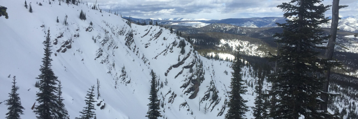
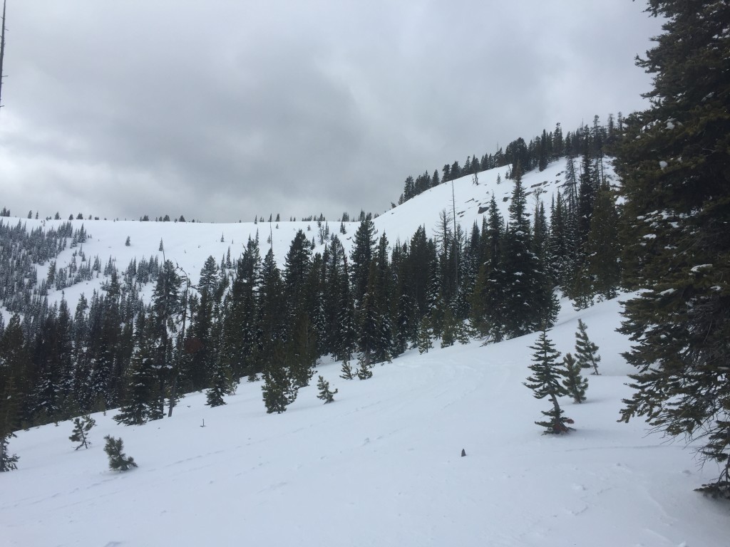
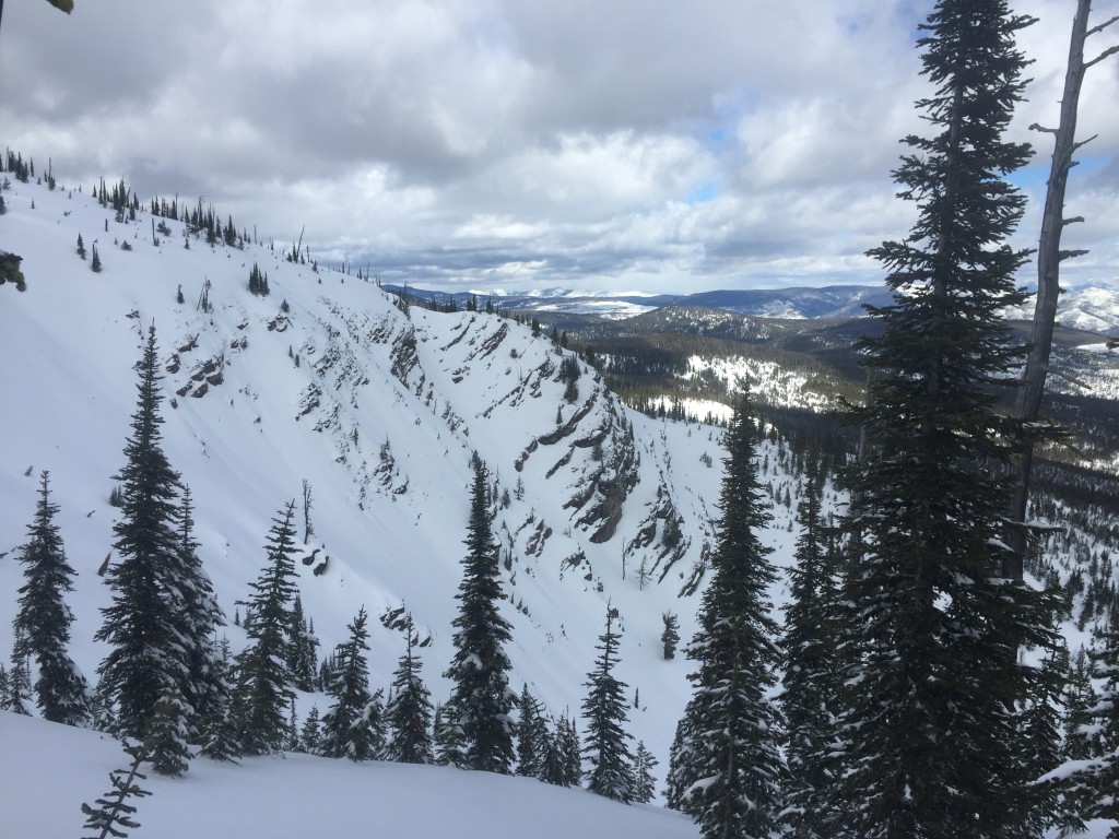
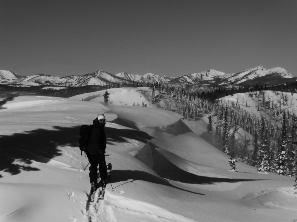
Tim and I were up at Wisherd ridge yesterday and Travis and Brian were down at Lost Trail over the weekend. We all observed heavily wind affected snow making the primary avalanche concern today windslabs above about 6500ft. Strong winds have been recorded and observed for nearly a week blowing primarily from the south and west. With minimal snow for transport windslabs have been found to be small and soft but widespread on aspects ranging from NW-SE. The variability of the windslabs is deceiving and small wind loaded pockets are easily missed especially on cross loaded terrain. Look carefully for any indications that a slope or terrain feature may be wind loaded.

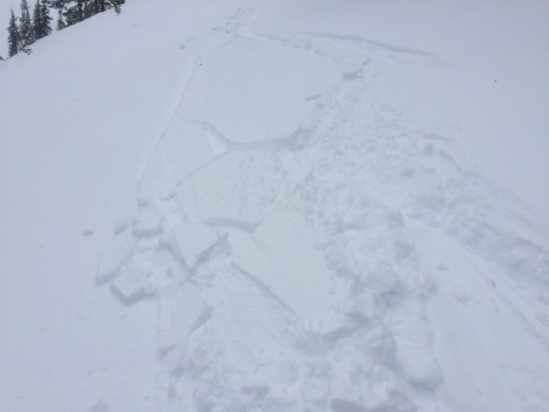
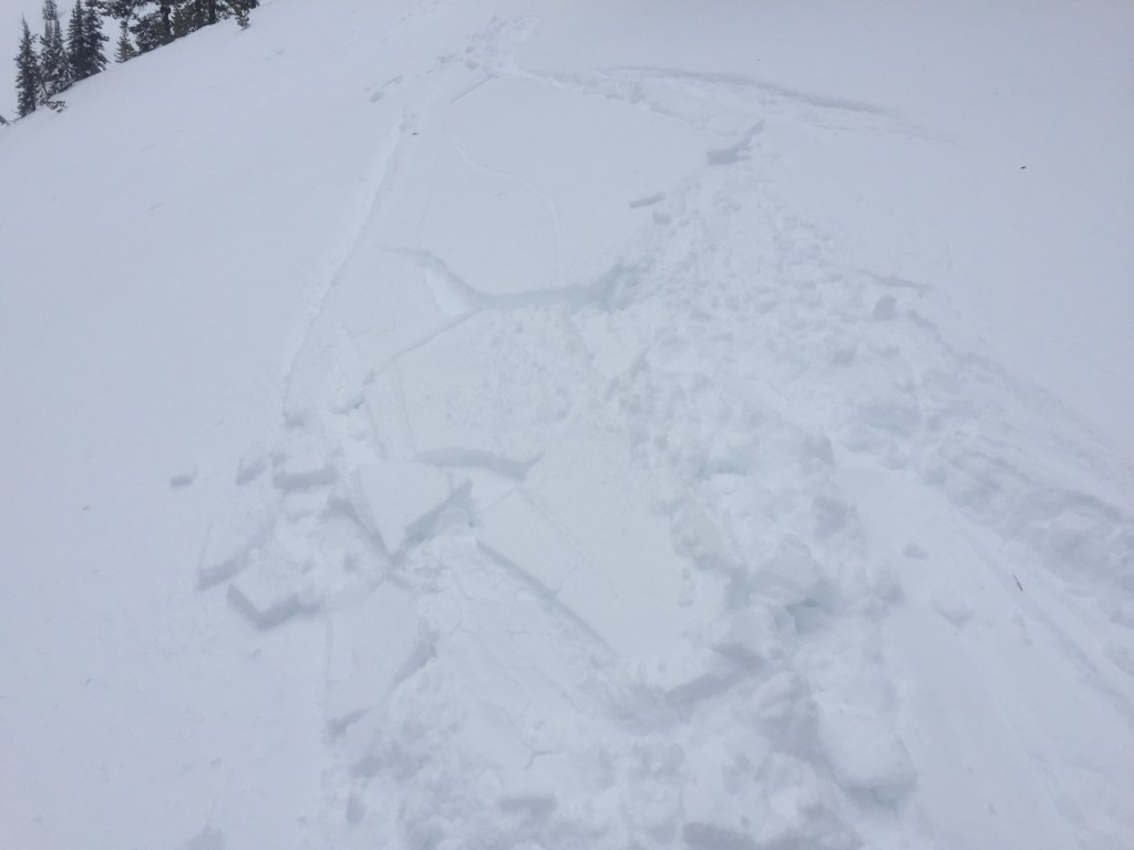
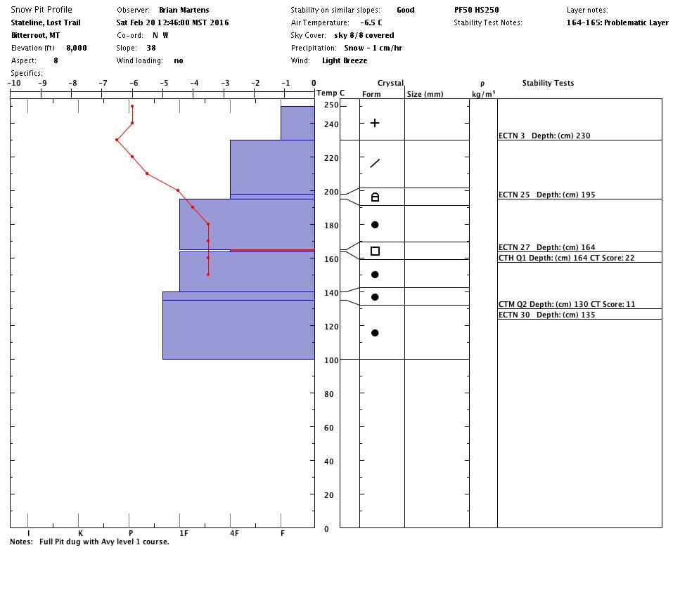
Multiple skier trigger slides were observed and reported over the last few days in the northern half of the advisory area, primarily in the Rattlesnake. These slides were occurring on the interface of the new snow and the old snow surface. This interface is slowly settling out but may required a few more days before it is no longer reactive. The layers of graupel above the melt freeze crust and facets below the melt freeze crust are becoming less reactive as well but still warrant careful evaluation before jumping onto a slope. If the graupel or facet layer does fail it will be significantly larger than the slides that have been triggered over the last few days with the potential for high consequences. 

Avalanche and Weather Outlook

As the high pressure system sets up over the region warm and relatively clear days are expected for the majority of the week. If cloud cover stays minimal cold clear nights will lead to surface hoar development which can be problematic when snow returns and buries this weak layer. Another possible concern with the warm and clear weather will be cornice fall. Travis and Brian observed the remnants of a natural cornice failure near Lost Trail and with the current forecast there will be potential for more of them so give cornices wide berths.

Travis will issue the next avalanche advisory on Thursday.

READ FULL ADVISORY  

Problem 1 - Wind slabs

  • TYPE

    wind-slabs

    Wind Slabs

    Release of a cohesive layer of snow (a slab) formed by the wind.  Wind typically erodes snow from the upwind sides of terrain features and deposits snow on the downwind side.  Wind slabs are often smooth and rounded and sometimes sound hollow, and can range from soft to hard. Wind slabs that form over a persistent weak layer (surface hoar, depth hoar, or near-surface facets) may be termed Persistent Slabs or may develop into Persistent Slabs.

  • SIZE

    3-4

    1-2 (Small-Large)

    The potential size of avalanche resulting from this problem.

  • LIKELIHOOD

    Likelihood-3

    Possible

    The likelihood of an avalanche resulting from this problem.

  • ADDED DANGER

    Increased Slope Danger

    Increased/Added Danger

    There is an increased risk of avalanches on these slopes:

    N - North
    NE - Northeast
    E - East
    SE - Southeast
    W - West
    NW - Northwest

Strong winds from the S and W for the better part of a week have lead to the formation of windslabs.

Problem 2 - Interface,Graupel,Facets

  • TYPE

    persistent-slabs

    Persistent Slabs

    Release of a cohesive layer of soft to hard snow (a slab) in the middle to upper snowpack, when the bond to an underlying persistent weak layer breaks.  Persistent layers include: surface hoar, depth hoar, near-surface facets, or faceted snow. Persistent weak layers can continue to produce avalanches for days, weeks or even months, making them especially dangerous and tricky. As additional snow and wind events build a thicker slab on top of the persistent weak layer, this avalanche problem may develop into a Persistent, Deep-Slab.

  • SIZE

    3-4

    1-2 (Small-Large)

    The potential size of avalanche resulting from this problem.

  • LIKELIHOOD

    Likelihood-3

    Possible

    The likelihood of an avalanche resulting from this problem.

  • IMAGE

Multiple small slides have been reported on the interface over the last few days and larger slides are possible on the graupel and facets found around the melt freeze crust.

Problem 3 - Cornice Fall

  • TYPE

    cornices

    Cornices / Cornice Fall

    Release of an overhanging mass of snow that forms as the wind moves snow over a sharp terrain feature, such as a ridge, and deposits snow on the down-wind side. They range from small wind lips of soft snow to large overhangs of hard snow that are 30 feet (~10 meters) or taller. They can break off the terrain suddenly and pull back onto the ridge top and catch people by surprise even on the flat ground above the slope. Even small cornices can have enough mass to be destructive and deadly. Cornice fall can entrain loose surface snow or trigger slab avalanches.

  • SIZE

    4-5

    2 (Large)

    The potential size of avalanche resulting from this problem.

  • LIKELIHOOD

    Likelihood-2

    Unlikely/Possible

    The likelihood of an avalanche resulting from this problem.

As temperatures rise cornices may fall.

FORECAST & OUTLOOK

High pressure is expected to dominate the region for the majority of the week.

This information is the sole responsibility of the Forest Service and does not apply to operating ski areas. The avalanche danger rating expires at midnight tonight but the information can help you make a more informed decision regarding travel in avalanche terrain for the next few days.

Our advisory area includes National Forest System lands in the Bitterroot Mountains from Lost Trail Pass north to Granite Pass, the Rattlesnake Mountains north of Missoula and the Southern Swan and Mission Mountains near Seeley Lake, MT. Avalanche information for the Lookout Pass/St. Regis Basin area is available from the Idaho Panhandle Avalanche Center.