Posted:
Apr 2, 2016 @ 6:21 am

The current avalanche danger is Moderate for the west central Montana backcountry. Spring skiing and riding conditions are in full effect, the danger will start as LOW this morning but will rapidly climb to MODERATE as the sun and warm temps start to affect the snow.

Good morning,  this is Logan King with the West Central Montana Avalanche Center’s avalanche advisory for Saturday, April 2nd, 2016. This will be the last regularly scheduled advisory of the season, but an update will be posted for next weekend and additional updates may follow if conditions warrant. Remember this danger rating does not apply to operating ski areas, expires at midnight tonight and is the sole responsibility of the U.S. Forest Service.

Weather and Snowpack

High pressure continues to build over west central Montana and conditions will be warm and dry again today. No new snow was seen overnight and winds are currently 25mph gusting to 30mph from the west at Point 6. Most mountain locations did not freeze overnight and temperatures are ranging from 28-33 degrees. 

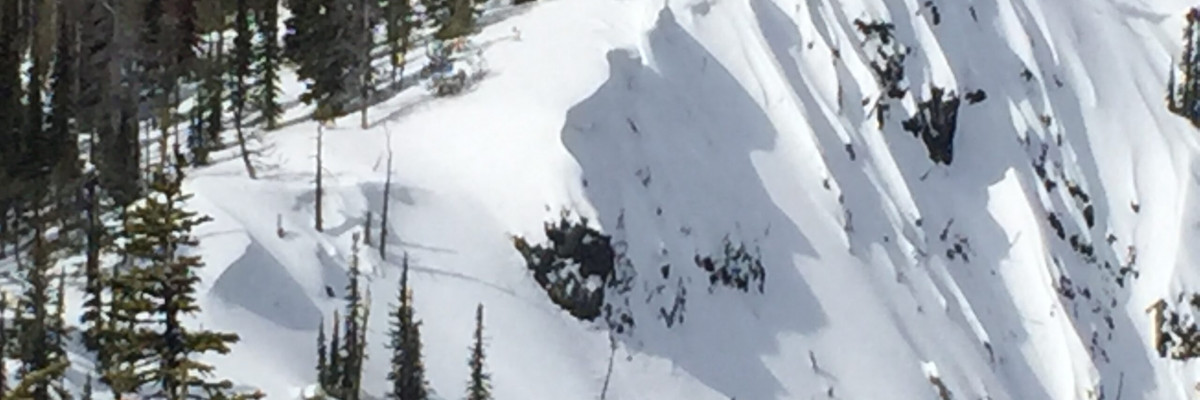
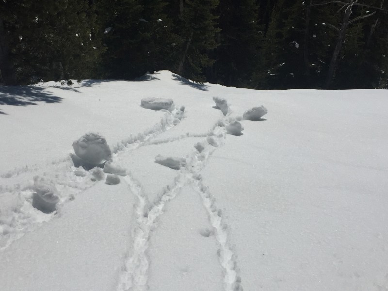
The primary avalanche concern today will be loose wet slides. Travis and Dudley were in the Rattlesnake yesterday and observed loose wet slides on all aspects and elevations. Loose snow activity will increase throughout the day as the sun warms the snow surface. If rollerballs or small point releases are observed on the aspects you are on, move to a more shaded aspect, and avoid terrain traps; loose wets slides can be fun to start or play with but they can be deadly. Keep in mind that there have been fatalities around the area that have resulted from small loose wet slides past, so don’t let your guard down.

The secondary avalanche concern will be persistent slabs. Facets  siting above crusts continue to be concerning but are no longer propagating. The persistent slabs may also become active as wet slabs as the snow is trending towards isothermal. Dig pits and perform stability tests to determine if the facets are present and if they are reactive, and don’t be afraid to err on the side of caution especially as the snow gets wet  later in the day.

Lastly, be wary of cornices. We have seen large cornices throughout the advisory area and without freezing overnight and warm sunny days its only a matter of time until they start dropping. Cornices have a really nasty habit of breaking back farther than expected and will be major hazards until the snow is gone.

Weather and Avalanche Outlook

A weak disturbance will move through the area tonight but snowfall will be unremarkable and snow levels will be high. The high pressure is expected to be the dominant feature over the weekend. Avalanche conditions will climb throughout the day, stay  aware of conditions as they change today.

Thanks for a wonderful season and stay safe out there. Steve will issue an update for next weekend.

READ FULL ADVISORY  

Problem 1 - Loose Wet

  • TYPE

    loose-wet

    Loose Wet

    Release of wet unconsolidated snow or slush. These avalanches typically occur within layers of wet snow near the surface of the snowpack, but they may quickly gouge into lower snowpack layers. Like Loose-Dry Avalanches,they start at a point and entrain snow as they move downhill, forming a fan-shaped avalanche. They generally move slowly, but can contain enough mass to cause significant damage to trees, cars or buildings. Other names for loose-wet avalanches include point-release avalanches or sluffs. Loose-wet avalanches can trigger slab avalanches that break into deeper snow layers.

  • SIZE

    2-3

    1 (Small)

    The potential size of avalanche resulting from this problem.

  • LIKELIHOOD

    Likelihood-4

    Possible/Likely

    The likelihood of an avalanche resulting from this problem.

  • ADDED DANGER

    Increased Slope Danger

    Increased/Added Danger

    There is an increased risk of avalanches on these slopes:

    N - North
    NE - Northeast
    E - East
    SE - Southeast
    S - South
    SW - Southwest
    W - West
    NW - Northwest

  • IMAGE

Size and frequency of loose wet slides will increase as the day progresses.

Problem 2 - Persitent Slabs

  • TYPE

    persistent-slabs

    Persistent Slabs

    Release of a cohesive layer of soft to hard snow (a slab) in the middle to upper snowpack, when the bond to an underlying persistent weak layer breaks.  Persistent layers include: surface hoar, depth hoar, near-surface facets, or faceted snow. Persistent weak layers can continue to produce avalanches for days, weeks or even months, making them especially dangerous and tricky. As additional snow and wind events build a thicker slab on top of the persistent weak layer, this avalanche problem may develop into a Persistent, Deep-Slab.

  • SIZE

    3-4

    1-2 (Small-Large)

    The potential size of avalanche resulting from this problem.

  • LIKELIHOOD

    Likelihood-2

    Unlikely/Possible

    The likelihood of an avalanche resulting from this problem.

Facets sitting on the crust are no longer propagating but still warrant attention.

Problem 3 - Cornices

  • TYPE

    cornices

    Cornices / Cornice Fall

    Release of an overhanging mass of snow that forms as the wind moves snow over a sharp terrain feature, such as a ridge, and deposits snow on the down-wind side. They range from small wind lips of soft snow to large overhangs of hard snow that are 30 feet (~10 meters) or taller. They can break off the terrain suddenly and pull back onto the ridge top and catch people by surprise even on the flat ground above the slope. Even small cornices can have enough mass to be destructive and deadly. Cornice fall can entrain loose surface snow or trigger slab avalanches.

  • SIZE

    5-6

    2-3 (Large)

    The potential size of avalanche resulting from this problem.

  • LIKELIHOOD

    Likelihood-3

    Possible

    The likelihood of an avalanche resulting from this problem.

Cornices are beginning to be problematic and will likely be a concern until the snow melts entirely.

VIDEO

FORECAST & OUTLOOK

Warm and sunny conditions are expected again today.

This information is the sole responsibility of the Forest Service and does not apply to operating ski areas. The avalanche danger rating expires at midnight tonight but the information can help you make a more informed decision regarding travel in avalanche terrain for the next few days.

Our advisory area includes National Forest System lands in the Bitterroot Mountains from Lost Trail Pass north to Granite Pass, the Rattlesnake Mountains north of Missoula and the Southern Swan and Mission Mountains near Seeley Lake, MT. Avalanche information for the Lookout Pass/St. Regis Basin area is available from the Idaho Panhandle Avalanche Center.