Posted:
Dec 31, 2016 @ 6:46 am

The current avalanche danger is CONSIDERABLE in the west central Montana backcountry.  This means careful snowpack evaluation, cautious route-finding and conservative decision-making are essential to recreate today.  Human triggered avalanches are likely.

Happy New Year!  This is Travis Craft with the West Central Montana Avalanche Center’s avalanche advisory for December 31, 2016. This danger rating does not apply to operating ski areas, expires at midnight tonight and is the sole responsibility of the U.S. Forest Service.

Weather and Snowpack

Mountain temperatures range from 7 F to 20 F in the region.  In the Bitterroot, winds are 10 mph with gusts of 16 mph out of the SW and Point Six, in the northern part of the advisory area, winds are reading 23 mph with gusts of 34 mph out of the WNW.  The forecast area received 0 to 2 inches of new snow in the last 24 hours.  The new snow had SWE’s ranging from 0 to .4 inches of water.

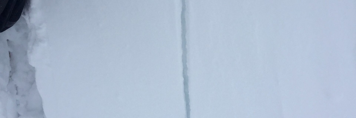
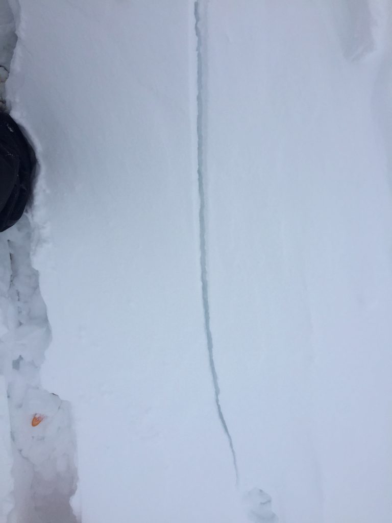
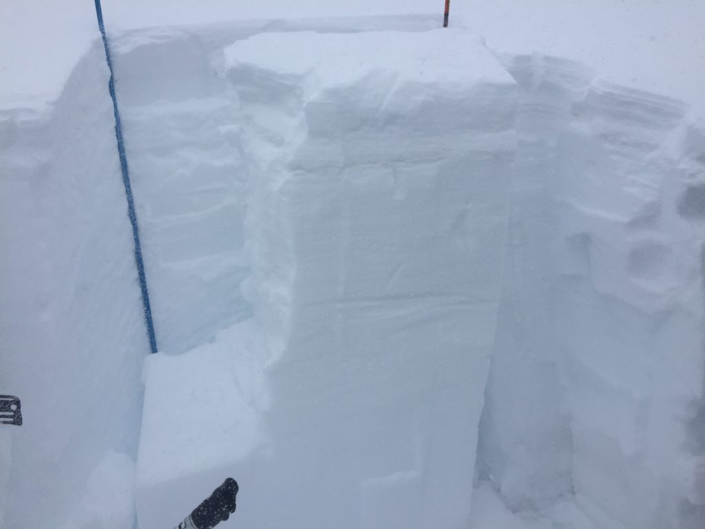
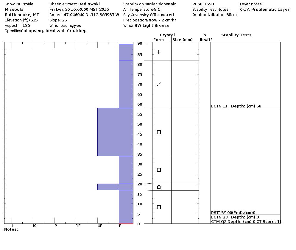
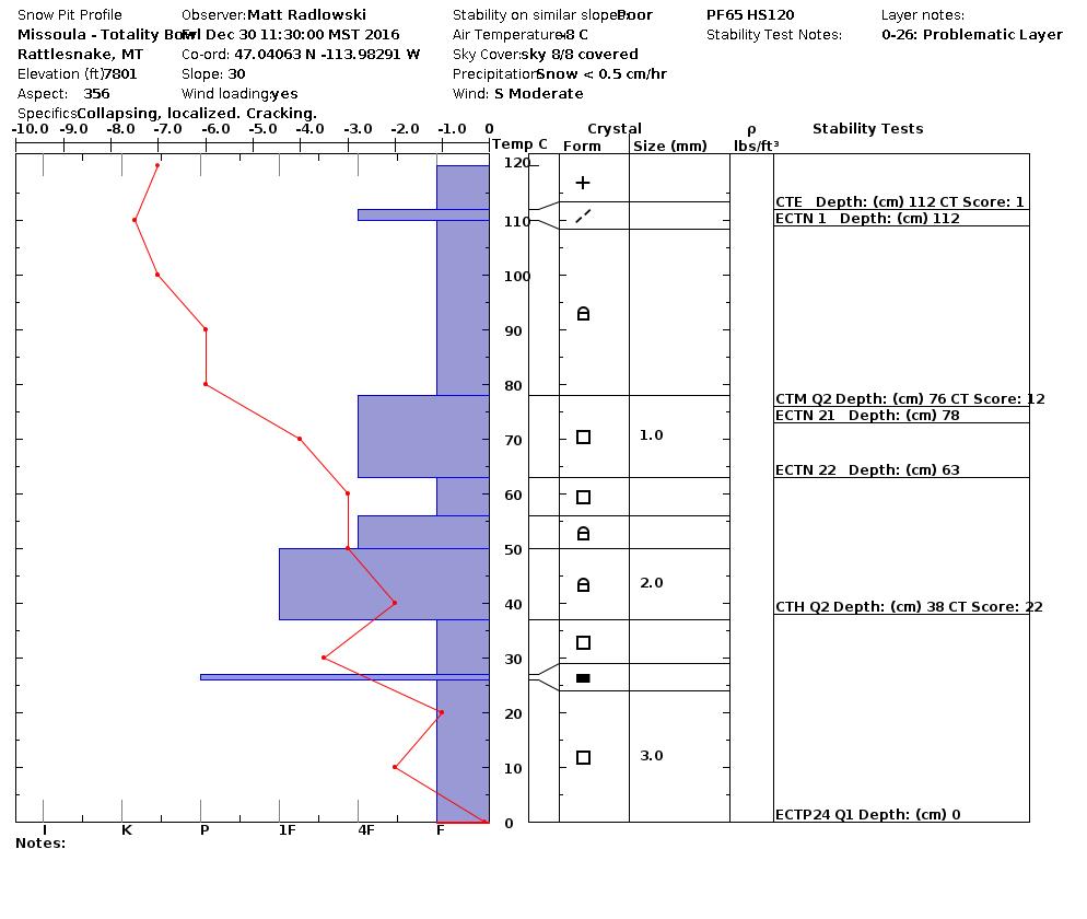
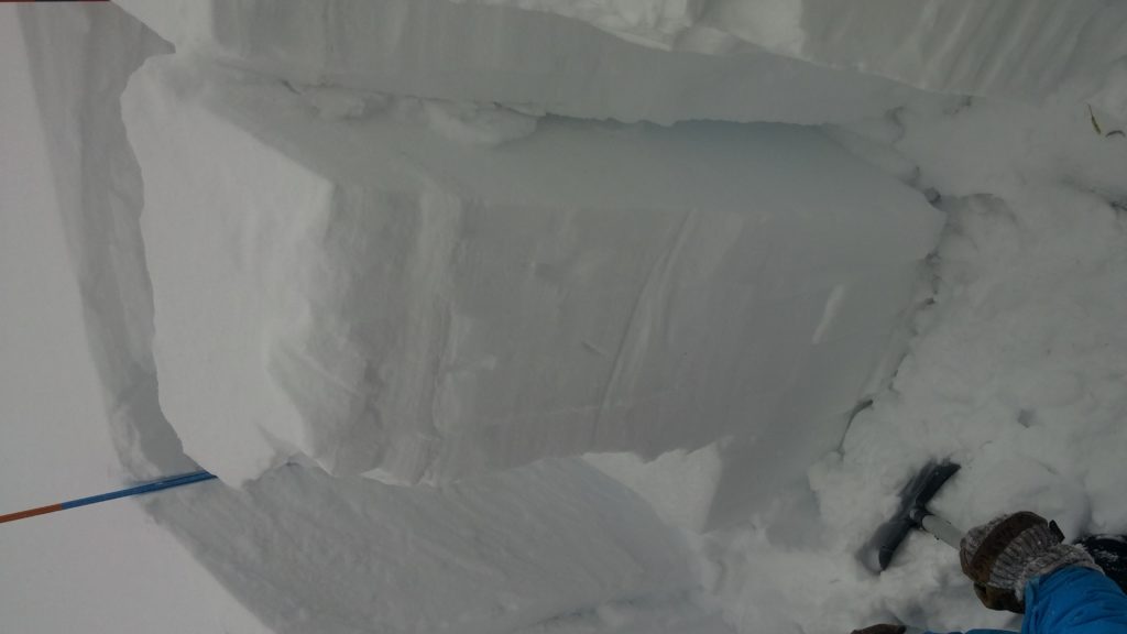
Matt and I toured in the Rattlesnake yesterday.  We observed shooting cracks from our skis and multiple aspects with wind slabs.  In our tests we found that the basal facets propagated at the ground.  Ed toured in the southern Bitterroot and he was able to get this layer to fail in compression tests, but not propagate.  Ed observed shooting cracks from his skis and slopes being cross-loaded.

The primary avalanche problem are wind slabs.  These are found on multiple aspects and some slopes are cross-loaded.  Winds have deposited wind slabs mid-slope and on ridge tops.

The second avalanche concern is the persistent slab that is releasing near the ground on basal facets.  Matt and I were able to get this layer to propagate in our tests yesterday.  This layer is more likely to be triggered in areas with a relative shallow snowpack (cliff bands, rollovers, and rock outcrops).  This layer takes a fair bit of force to trigger, but the consequences are very high.  I would dig a pit and assess this layer before committing to any steep terrain.

Avalanche and Weather Outlook

An arctic front will enter the area tonight bringing with it snow and gusty winds throughout the weekend.  Temperatures are forecasted to drop significantly by Monday.  With the addition of new snow and gusting high winds the avalanche danger will increase.

I will issue the next advisory on January 03, 2017.

Ski and ride safe into the new year.


READ FULL ADVISORY  

Problem 1 - Wind Slabs

  • TYPE

    wind-slabs

    Wind Slabs

    Release of a cohesive layer of snow (a slab) formed by the wind.  Wind typically erodes snow from the upwind sides of terrain features and deposits snow on the downwind side.  Wind slabs are often smooth and rounded and sometimes sound hollow, and can range from soft to hard. Wind slabs that form over a persistent weak layer (surface hoar, depth hoar, or near-surface facets) may be termed Persistent Slabs or may develop into Persistent Slabs.

  • SIZE

    4-5

    2 (Large)

    The potential size of avalanche resulting from this problem.

  • LIKELIHOOD

    Likelihood-5

    Likely

    The likelihood of an avalanche resulting from this problem.

  • ADDED DANGER

    Increased Slope Danger

    Increased/Added Danger

    There is an increased risk of avalanches on these slopes:

    N - North
    NE - Northeast
    E - East
    SE - Southeast
    S - South
    SW - Southwest
    W - West
    NW - Northwest

  • IMAGE

Winds have shifted directions during the storms and have loaded many different aspects.  Some slopes are cross-loaded.  Winds have deposited wind slabs mid-slope and on ridge tops.

Problem 2 - Persistent Slabs

  • TYPE

    persistent-slabs

    Persistent Slabs

    Release of a cohesive layer of soft to hard snow (a slab) in the middle to upper snowpack, when the bond to an underlying persistent weak layer breaks.  Persistent layers include: surface hoar, depth hoar, near-surface facets, or faceted snow. Persistent weak layers can continue to produce avalanches for days, weeks or even months, making them especially dangerous and tricky. As additional snow and wind events build a thicker slab on top of the persistent weak layer, this avalanche problem may develop into a Persistent, Deep-Slab.

  • SIZE

    6-7

    3 (Large-Very Large)

    The potential size of avalanche resulting from this problem.

  • LIKELIHOOD

    Likelihood-4

    Possible/Likely

    The likelihood of an avalanche resulting from this problem.

  • IMAGE

The basal facets are reactive in ECT and PST tests.  This layer will likely be triggered in areas with a relatively shallow snowpack (cliff bands, rollovers, and rock outcrops).

VIDEO

Observations 12/30/2016

Observations 12/30/2016

FORECAST & OUTLOOK

An arctic front will enter the area tonight bringing snow and gusty winds throughout the weekend. Temperatures will drop significantly by Monday.

This information is the sole responsibility of the Forest Service and does not apply to operating ski areas. The avalanche danger rating expires at midnight tonight but the information can help you make a more informed decision regarding travel in avalanche terrain for the next few days.

Our advisory area includes National Forest System lands in the Bitterroot Mountains from Lost Trail Pass north to Granite Pass, the Rattlesnake Mountains north of Missoula and the Southern Swan and Mission Mountains near Seeley Lake, MT. Avalanche information for the Lookout Pass/St. Regis Basin area is available from the Idaho Panhandle Avalanche Center.