Posted:
Jan 5, 2017 @ 6:25 am

The current avalanche danger is MODERATE in the West Central Montana backcountry. Large human triggered avalanches are possible in isolated areas and careful evaluation of conditions will be required before recreating in avalanche terrain.

Good morning, this is Logan King with the West Central Montana Avalanche Center’s avalanche advisory for January 5th, 2017.  This danger rating does not apply to operating ski areas, expires at midnight tonight and is the sole responsibility of the U.S. Forest Service.

Weather and Snowpack

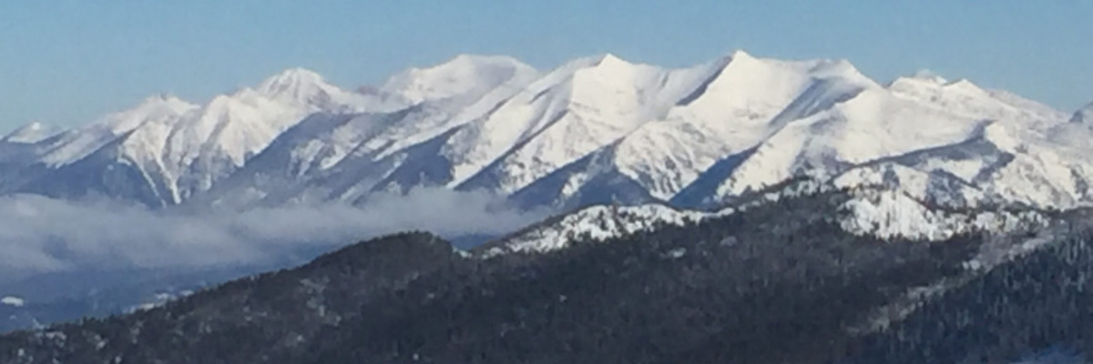
For the last 24 hours ridge-top winds have prevailed from the east to northeast but are shifting back towards a northwesterly flow this morning and have dropped to 14mph gusts at Point 6. Strong easterly winds aloft were visible from Missoula yesterday as trails of snow could be seen blowing off of Carlton Ridge and Lolo Peak. Mountain temperatures continue to be frigid and are ranging from -16 to 1 degree fahrenheit this morning. No new snow was seen in the advisory area overnight.

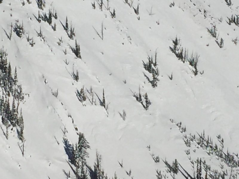
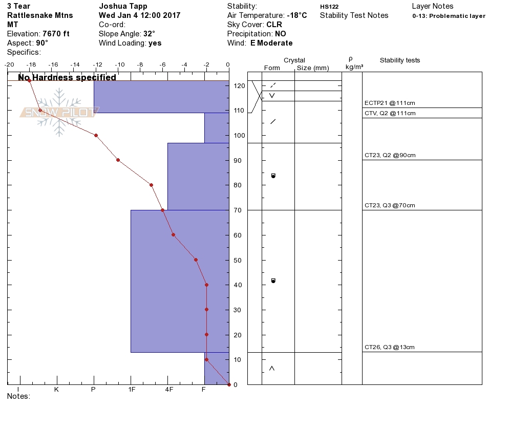
The primary avalanche concern today will be windslabs. With strong easterly winds, windslabs and cross loading can be found on nearly all aspects. Yesterday in the Rattlesnake we found the windslab to propagate with moderate force in extended column tests. With unusual winds you will see unusual windslab development so take the time to assess each slope independently to determine if windloading has occurred (video).

Persistent slabs continue to be a concern due to facets on the ground. The facets have gained strength over the last week but the healing process has slowed with the cold temperatures. Small isolated layers of buried surface hoar were reactive in stability tests yesterday as well and with windslabs and buried surface hoar reacting the possibly of an avalanche stepping down to the basal facets is a significant concern.

Avalanche and Weather Outlook.

Cold and Clear conditions will persist today, before giving way to the next system that should be arriving this weekend. Snow levels look to climb along with temperatures as the weather shifts at the tail end of the week. Avalanche conditions will be consistent until the weather pattern changes. 

If you get out in the backcountry please feel free to share your observations on the public observations page. I will Issue the next advisory on Saturday.

Stay warm out there.

READ FULL ADVISORY  

Problem 1 - Windslabs

  • TYPE

    wind-slabs

    Wind Slabs

    Release of a cohesive layer of snow (a slab) formed by the wind.  Wind typically erodes snow from the upwind sides of terrain features and deposits snow on the downwind side.  Wind slabs are often smooth and rounded and sometimes sound hollow, and can range from soft to hard. Wind slabs that form over a persistent weak layer (surface hoar, depth hoar, or near-surface facets) may be termed Persistent Slabs or may develop into Persistent Slabs.

  • SIZE

    3-4

    1-2 (Small-Large)

    The potential size of avalanche resulting from this problem.

  • LIKELIHOOD

    Likelihood-3

    Possible

    The likelihood of an avalanche resulting from this problem.

  • IMAGE

With Strong winds and unusual wind-directions windslabs can be found on nearly all aspects and in areas that are typically wind-scoured.

Problem 2 - Persistent Slabs

  • TYPE

    persistent-slabs

    Persistent Slabs

    Release of a cohesive layer of soft to hard snow (a slab) in the middle to upper snowpack, when the bond to an underlying persistent weak layer breaks.  Persistent layers include: surface hoar, depth hoar, near-surface facets, or faceted snow. Persistent weak layers can continue to produce avalanches for days, weeks or even months, making them especially dangerous and tricky. As additional snow and wind events build a thicker slab on top of the persistent weak layer, this avalanche problem may develop into a Persistent, Deep-Slab.

  • SIZE

    4-5

    2 (Large)

    The potential size of avalanche resulting from this problem.

  • LIKELIHOOD

    Likelihood-3

    Possible

    The likelihood of an avalanche resulting from this problem.

Facets near the ground continue to be reactive in compression tests, especially in areas with a shallower snowpack.

VIDEO

FORECAST & OUTLOOK

Cold and clear conditions will continue today, and the next weather system is expected to arrive over the weekend.

This information is the sole responsibility of the Forest Service and does not apply to operating ski areas. The avalanche danger rating expires at midnight tonight but the information can help you make a more informed decision regarding travel in avalanche terrain for the next few days.

Our advisory area includes National Forest System lands in the Bitterroot Mountains from Lost Trail Pass north to Granite Pass, the Rattlesnake Mountains north of Missoula and the Southern Swan and Mission Mountains near Seeley Lake, MT. Avalanche information for the Lookout Pass/St. Regis Basin area is available from the Idaho Panhandle Avalanche Center.