Posted:
Feb 7, 2017 @ 6:36 am

The current avalanche danger is HIGH in the west central Montana backcountry.  Travel in avalanche terrain is not recommended today.  Human triggered avalanches are very likely and natural avalanches are likely.  Avoid runout zones.

Good morning, this is Travis Craft with the West Central Montana Avalanche Center’s avalanche advisory for February 07, 2017. This danger rating does not apply to operating ski areas, expires at midnight tonight and is the sole responsibility of the U.S. Forest Service.

Weather and Snowpack

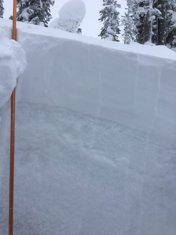
Mountain temperatures range from 8 F to 22 F in the region. Winds are 6 mph with gusts of 10 mph out of the SSW in the Bitterroot. Point Six, in the northern part of the advisory area, winds are reading 10 mph with gusts of 18 mph out of the W. The region has picked up 5 to 7 new inches of snow in the last 24 hours. The new snow had SWE’s ranging from .3 to .6 inches of water.  Temperatures have cooled overnight.

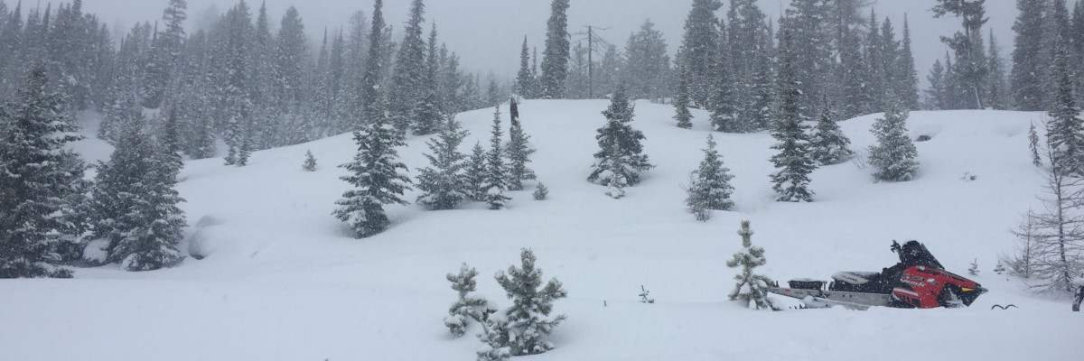
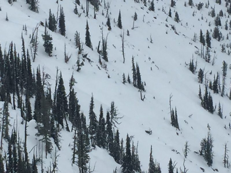
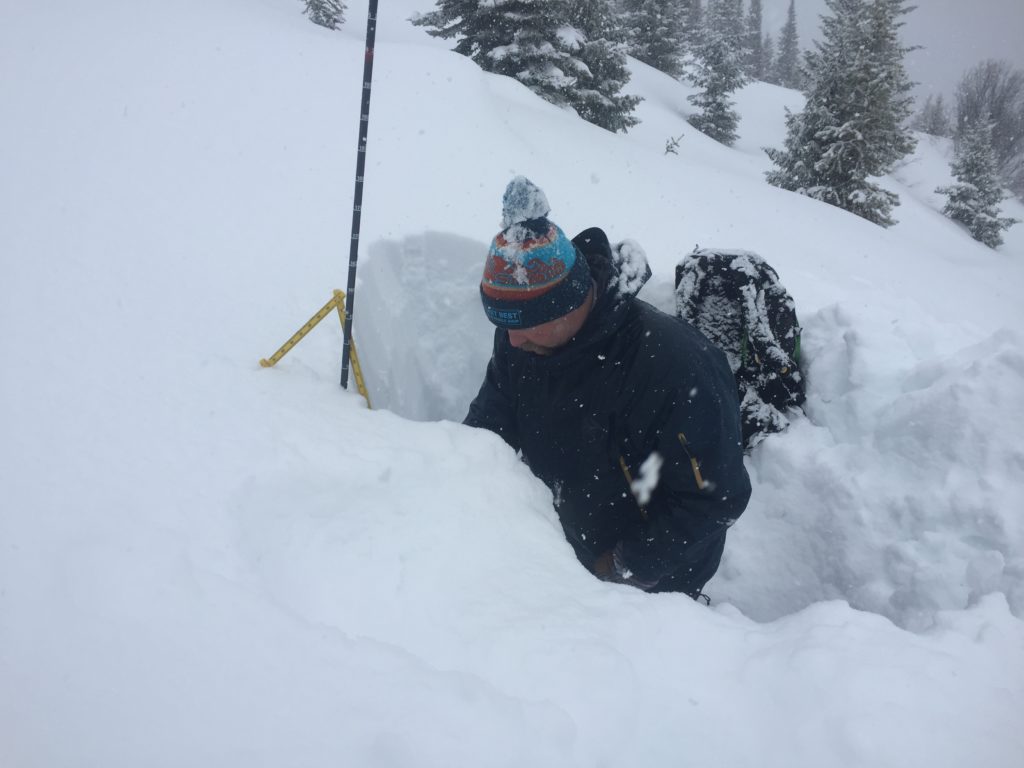
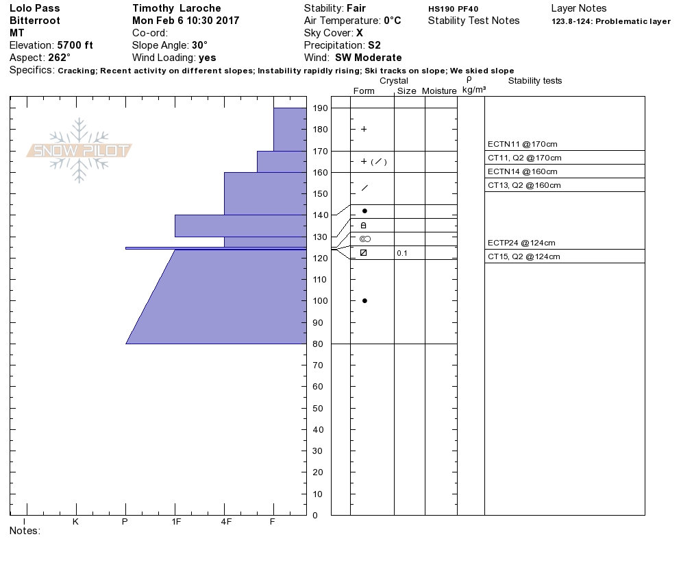
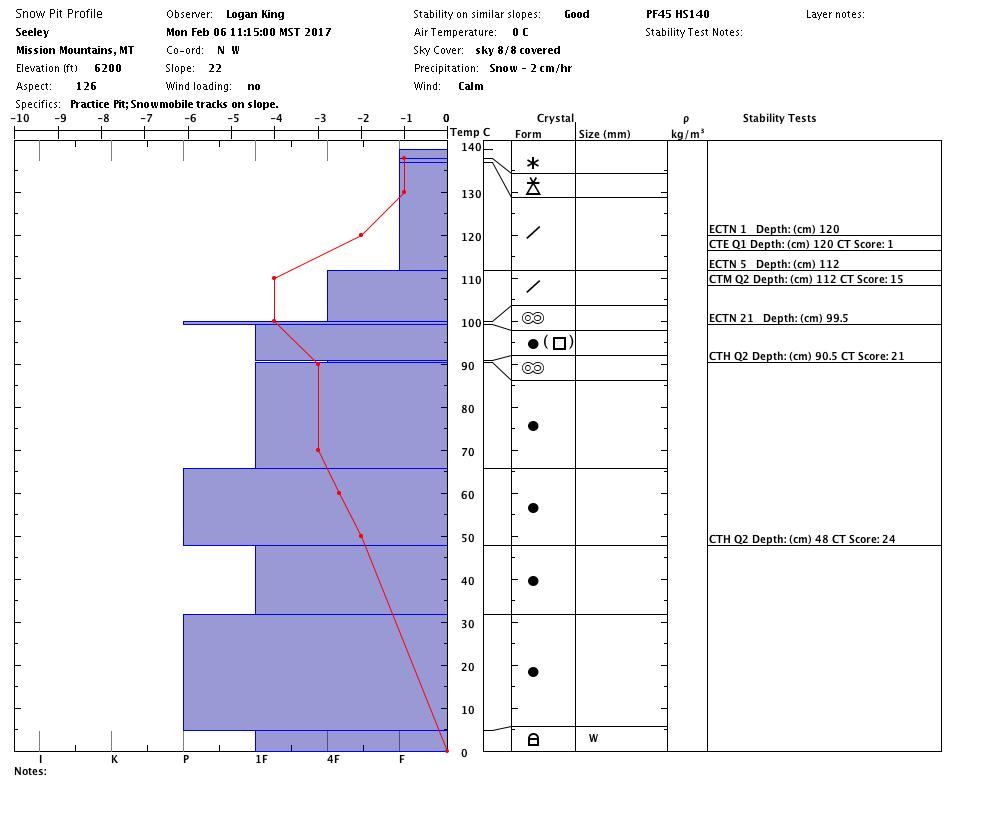
Logan and I took the sleds to the southern Missions yesterday.  Tim and Greg went to Lolo Pass yesterday.  Josh and Matt were in the Rattlesnake over the weekend teaching a level 1 avalanche course.  We all observed new loading and high winds.  The new snow needs time to bond with the old snow surfaces.  We got propagation on persistent weak layers in the Rattlesnake and Lolo Pass(video).  The snow was very dense and felt slabby.

The primary avalanche problem is wind slabs.  There is a lot of new low-density snow that fell overnight that loaded leeward aspects.  Identify wind loaded terrain and avoid it.  Stay away from lower angle terrain connected to steeper terrain and avoid runout zones.

The second avalanche concern is persistent slabs.  There are multiple weak layers in our snowpack that the new loading of snow has made reactive.  There is the possibility of triggering a layer and having it step down to the lower weak layers.  Avoid runout zones.  Stick to lower angle terrain.

The final avalanche problem is storm slabs.  There is significant new snow in the area, and the snowpack needs time to adjust to the new load of snow.  Stick to lower angle terrain and give this snow time to settle.

Avalanche and Weather Outlook

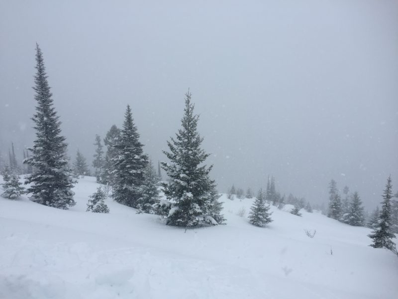
In our advisory area temperatures dropped throughout the day and night and it is currently snowing.  Our region is predicted to accumulate more light snow through Wednesday.  A warmer air mass is predicted to move in Wednesday night raising temperatures.  The additional snow will keep our avalanche danger the same.

If you are out in the backcountry, please send us your observations, these are very helpful in producing the advisory.  I will issue the next advisory on February 09, 2017.

Ski and ride safe.


READ FULL ADVISORY  

Problem 1 - Wind Slabs

  • TYPE

    wind-slabs

    Wind Slabs

    Release of a cohesive layer of snow (a slab) formed by the wind.  Wind typically erodes snow from the upwind sides of terrain features and deposits snow on the downwind side.  Wind slabs are often smooth and rounded and sometimes sound hollow, and can range from soft to hard. Wind slabs that form over a persistent weak layer (surface hoar, depth hoar, or near-surface facets) may be termed Persistent Slabs or may develop into Persistent Slabs.

  • SIZE

    5-6

    2-3 (Large)

    The potential size of avalanche resulting from this problem.

  • LIKELIHOOD

    Likelihood-6

    Likely/Very Likely

    The likelihood of an avalanche resulting from this problem.

  • IMAGE

New wind slabs have been deposited on leeward slopes.

Problem 2 - Persistent Slabs

  • TYPE

    persistent-slabs

    Persistent Slabs

    Release of a cohesive layer of soft to hard snow (a slab) in the middle to upper snowpack, when the bond to an underlying persistent weak layer breaks.  Persistent layers include: surface hoar, depth hoar, near-surface facets, or faceted snow. Persistent weak layers can continue to produce avalanches for days, weeks or even months, making them especially dangerous and tricky. As additional snow and wind events build a thicker slab on top of the persistent weak layer, this avalanche problem may develop into a Persistent, Deep-Slab.

  • SIZE

    5-6

    2-3 (Large)

    The potential size of avalanche resulting from this problem.

  • LIKELIHOOD

    Likelihood-6

    Likely/Very Likely

    The likelihood of an avalanche resulting from this problem.

  • ADDED DANGER

    Increased Slope Danger

    Increased/Added Danger

    There is an increased risk of avalanches on these slopes:

    N - North
    NE - Northeast
    E - East
    SE - Southeast
    S - South
    SW - Southwest
    W - West
    NW - Northwest

  • IMAGE

Weak layers in the snow pack are reactive with the new loading.

Problem 3 - Strom Slabs

  • TYPE

    storm-slabs

    Storm Slabs

    Release of a soft cohesive layer (a slab) of new snow which breaks within the storm snow or on the old snow surface. Storm-slab problems typically last between a few hours and few days. Storm-slabs that form over a persistent weak layer (surface hoar, depth hoar, or near-surface facets) may be termed Persistent Slabs or may develop into Persistent Slabs.

  • SIZE

    3-4

    1-2 (Small-Large)

    The potential size of avalanche resulting from this problem.

  • LIKELIHOOD

    Likelihood-5

    Likely

    The likelihood of an avalanche resulting from this problem.

  • ADDED DANGER

    Increased Slope Danger

    Increased/Added Danger

    There is an increased risk of avalanches on these slopes:

    N - North
    NE - Northeast
    E - East
    SE - Southeast
    S - South
    SW - Southwest
    W - West
    NW - Northwest

  • IMAGE

New snow from the last 48 hours needs time to settle out.

VIDEO

Observations 02/06/2017

Observations 02/06/2017

FORECAST & OUTLOOK

New snow will keep the avalanche danger the same.

This information is the sole responsibility of the Forest Service and does not apply to operating ski areas. The avalanche danger rating expires at midnight tonight but the information can help you make a more informed decision regarding travel in avalanche terrain for the next few days.

Our advisory area includes National Forest System lands in the Bitterroot Mountains from Lost Trail Pass north to Granite Pass, the Rattlesnake Mountains north of Missoula and the Southern Swan and Mission Mountains near Seeley Lake, MT. Avalanche information for the Lookout Pass/St. Regis Basin area is available from the Idaho Panhandle Avalanche Center.