Posted:
Nov 21, 2017 @ 7:33 am

Good morning, this is Travis Craft with the West Central Montana Avalanche Center’s early season update for November 21, 2017.

Mountain temperatures range from 26 F to 32 F in the region. Winds are 8 mph with gusts of 10 mph out of the SSW in the Bitterroot. Point Six, in the northern part of the advisory area, winds are reading 9 mph with gusts of 12 mph out of the SSW. The region has picked up 4 to 10 new inches of snow in the last 24 hours. The new snow had SWE’s ranging from .3 to 1.4  inches of water.

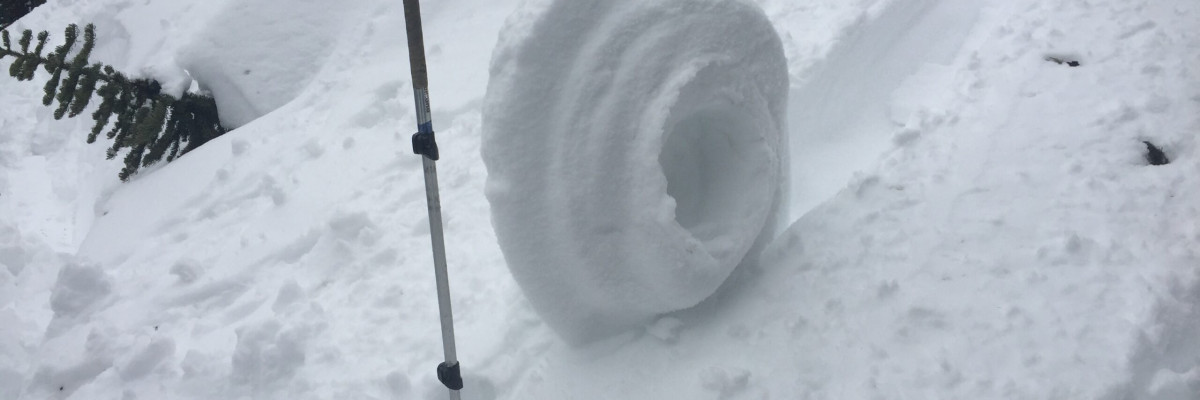
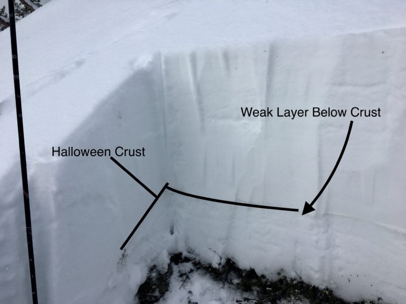
Josh and I toured in the Rattlesnake on Sunday before this storm entered our advisory area. We found wind slabs. We were able to get the facets under the Halloween crust to propagate in ECT’s.

Warming temperatures and rising freezing levels will increase the avalanche danger. Rain on snow will increase the Avalanche Danger. Natural avalanche activity will increase with the current and predicted weather.

The primary avalanche problem is storms slabs. The area received significant new snow. Monitor how well the new snow is bonding to older surfaces and avoid wind loaded slopes.

The second concern is persistent slabs. The layer of facets under the Halloween crust will be more reactive with new loading and rain added to the snowpack. You can reduce your risk by traveling on lower angled terrain.

The third avalanche problem will be loose wet releases. With rising temperatures and rain on our dry snowpack, loose wet releases will be triggered naturally and have the potential to become quite large. Pay attention to slopes above you.

With the current weather and predicted weather, the avalanche danger can change quickly.

Across western Montana, there are backcountry locations that experienced wildfires during the 2017 season. Temporary emergency trail closures for the Lolo Peak (from the Mormon Ridge trailhead), Mill Creek and the Lantern Ridge trails. These burned areas, while sometimes opening up new skiable terrain, may also present hazards for backcountry skiers. Trees burned may have weakened or completely burned root systems. They could fall without warning – even in no wind conditions. Trees and other vegetation that may have anchored snow on steeper slopes in past years may now be completely burned. Downed trees from a fire can create unseen hazards on shallow snowpacks.

As always, be observant of conditions – not just the snowpack, but also what is above the snow when moving through a recently burned area, especially in strong and gusty winds.

If you see any of these obvious clues (listed below) signaling dangerous snow conditions, avoid being on or under open slopes steeper than 30 degrees.

Recent avalanche activity
Cracking or collapsing snowpack
Heavy snowfall
High winds
Rapid increase in temperature
If you spend any amount of time in the mountains in the winter, chances are good that you will encounter avalanche terrain.  Having basic awareness of terrain, weather and snow factors goes a long way toward making good decisions in avalanche terrain.  To assist you, we are offering several basic and advanced avalanche awareness classes this winter. We also have instructors available to provide your organization a range of programs from introductory lectures to classes with a field component.

Any information you can provide and send the WCMAC is appreciated and helps us inform the rest of the community about avalanche safety conditions. Please send a quick email to [email protected] or complete the form here public observation.

We will update the advisory as the weather dictates and plan to begin issuing regular avalanche advisories with a danger rating in mid-December.


READ FULL ADVISORY  

Problem 1 - Storm Slabs

  • TYPE

    storm-slabs

    Storm Slabs

    Release of a soft cohesive layer (a slab) of new snow which breaks within the storm snow or on the old snow surface. Storm-slab problems typically last between a few hours and few days. Storm-slabs that form over a persistent weak layer (surface hoar, depth hoar, or near-surface facets) may be termed Persistent Slabs or may develop into Persistent Slabs.

  • SIZE

    3-4

    1-2 (Small-Large)

    The potential size of avalanche resulting from this problem.

  • LIKELIHOOD

    Likelihood-5

    Likely

    The likelihood of an avalanche resulting from this problem.

  • ADDED DANGER

    Increased Slope Danger

    Increased/Added Danger

    There is an increased risk of avalanches on these slopes:

    N - North
    NE - Northeast
    E - East
    SE - Southeast
    S - South
    SW - Southwest
    W - West
    NW - Northwest

Significant new snow. Monitor how well the new snow is bonding to older surfaces and avoid wind loaded slopes. Conditions will change rapidly with the rising temperatures and rain on our dry snowpack.

Problem 2 - Persistent Slabs

  • TYPE

    persistent-slabs

    Persistent Slabs

    Release of a cohesive layer of soft to hard snow (a slab) in the middle to upper snowpack, when the bond to an underlying persistent weak layer breaks.  Persistent layers include: surface hoar, depth hoar, near-surface facets, or faceted snow. Persistent weak layers can continue to produce avalanches for days, weeks or even months, making them especially dangerous and tricky. As additional snow and wind events build a thicker slab on top of the persistent weak layer, this avalanche problem may develop into a Persistent, Deep-Slab.

  • SIZE

    4-5

    2 (Large)

    The potential size of avalanche resulting from this problem.

  • LIKELIHOOD

    Likelihood-4

    Possible/Likely

    The likelihood of an avalanche resulting from this problem.

  • ADDED DANGER

    Increased Slope Danger

    Increased/Added Danger

    There is an increased risk of avalanches on these slopes:

    N - North
    NE - Northeast
    E - East
    SE - Southeast
    S - South
    SW - Southwest
    W - West
    NW - Northwest

  • IMAGE

The facets located under our Halloween crust have been reactive in tests. With the addition of new snow and rain this layer will become more reactive. You can reduce your risk by traveling on lower angled terrain.

Problem 3 - Loose Wet

  • TYPE

    loose-wet

    Loose Wet

    Release of wet unconsolidated snow or slush. These avalanches typically occur within layers of wet snow near the surface of the snowpack, but they may quickly gouge into lower snowpack layers. Like Loose-Dry Avalanches,they start at a point and entrain snow as they move downhill, forming a fan-shaped avalanche. They generally move slowly, but can contain enough mass to cause significant damage to trees, cars or buildings. Other names for loose-wet avalanches include point-release avalanches or sluffs. Loose-wet avalanches can trigger slab avalanches that break into deeper snow layers.

  • SIZE

    3-4

    1-2 (Small-Large)

    The potential size of avalanche resulting from this problem.

  • LIKELIHOOD

    Likelihood-6

    Likely/Very Likely

    The likelihood of an avalanche resulting from this problem.

  • ADDED DANGER

    Increased Slope Danger

    Increased/Added Danger

    There is an increased risk of avalanches on these slopes:

    N - North
    NE - Northeast
    E - East
    SE - Southeast
    S - South
    SW - Southwest
    W - West
    NW - Northwest

With rising temperatures and rain to above 8000 feet, loose wet releases will likely naturally trigger and could become large. Pay attention to slopes above you.

FORECAST & OUTLOOK

More wind this weekend and chances of precipitation later next week. The backcountry forecast is now being produced on our resources page. Here is the link.

This information is the sole responsibility of the Forest Service and does not apply to operating ski areas. The avalanche danger rating expires at midnight tonight but the information can help you make a more informed decision regarding travel in avalanche terrain for the next few days.

Our advisory area includes National Forest System lands in the Bitterroot Mountains from Lost Trail Pass north to Granite Pass, the Rattlesnake Mountains north of Missoula and the Southern Swan and Mission Mountains near Seeley Lake, MT. Avalanche information for the Lookout Pass/St. Regis Basin area is available from the Idaho Panhandle Avalanche Center.