Posted:
Dec 18, 2017 @ 7:07 am

Good morning, this is Travis Craft with the West Central Montana Avalanche Center’s weather and avalanche update for December 18, 2017. This danger rating does not apply to operating ski areas, expires at midnight tonight and is the sole responsibility of the U.S. Forest Service.

Weather and Snowpack

Mountain temperatures range from 23 F to 33 F in the region. Winds are 10 mph with gusts of 19 mph out of the S in the Bitterroot. Point Six, in the northern part of the advisory area, winds are 27 mph with gusts of 43 mph out of the W.  The advisory area received 1 to 5 inches of snow in the last 24 hours.  The new snow had SWE’s ranging from .1 to .7 inches of water.

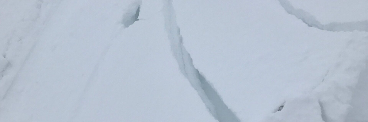
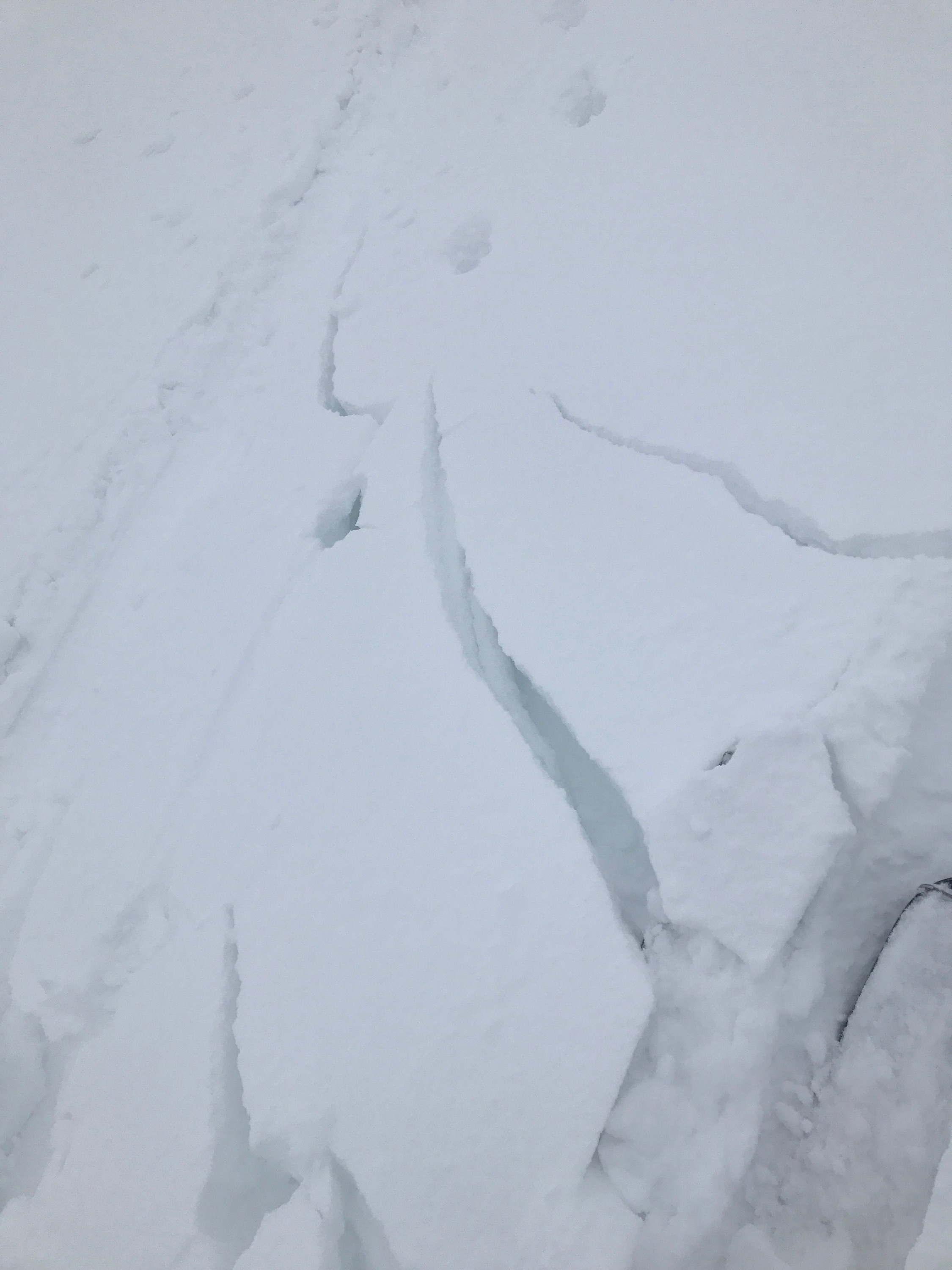
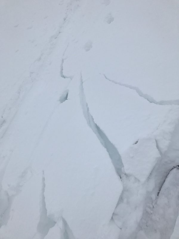
The addition of new snow and wind overnight has increased the avalanche danger.   Wind slabs will be larger and more sensitive to human triggers.  The near surface facets will become more sensitive to triggers with the additional weight of the new snow.  We got an observation yesterday before this storm from 7500 ft in the Missions, in the Grey Wolf area,  6 inch wind slabs that were sensitive to human triggers at 7500 feet (this is outside of the advisory area).   Here is picture.

The primary avalanche problem is wind slabs.  Leeward terrain and cross-loaded slopes will have wind slabs.  Look for rounded pillows of snow near ridgelines and recognize signs of instability such as cracking in the surface snow.  These slabs will be sensitive to human triggers.

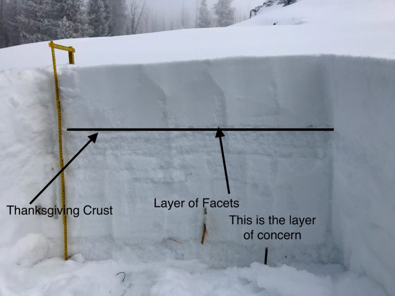
The secondary avalanche problem is persistent slabs.  The new snow will be stressing the layers of concern.  The two layers of concern are the buried surface hoar and the near surface facets on top of the Thanksgiving crust.  Dig a pit to assess how reactive these layers are before committing to any slope over 30 degrees.

We will have a weather pattern that is active till Wednesday.  With the addition of new snow and wind, the avalanche danger will increase throughout the day.  If you are out in the backcountry, please send us your observation, these are very helpful in producing the advisory.  I will issue the next advisory with a danger rating tomorrow.

Ski and ride safe.


READ FULL ADVISORY  

Problem 1 - Wind Slabs

  • TYPE

    wind-slabs

    Wind Slabs

    Release of a cohesive layer of snow (a slab) formed by the wind.  Wind typically erodes snow from the upwind sides of terrain features and deposits snow on the downwind side.  Wind slabs are often smooth and rounded and sometimes sound hollow, and can range from soft to hard. Wind slabs that form over a persistent weak layer (surface hoar, depth hoar, or near-surface facets) may be termed Persistent Slabs or may develop into Persistent Slabs.

  • SIZE

    3-4

    1-2 (Small-Large)

    The potential size of avalanche resulting from this problem.

  • LIKELIHOOD

    Likelihood-5

    Likely

    The likelihood of an avalanche resulting from this problem.

  • IMAGE

Leeward terrain and cross loaded slopes will have wind slabs.  Look for rounded pillows of snow near ridgelines and recognize signs of instability such as cracking in the surface snow.  These slabs will be sensitive to human triggers.


Problem 2 - Persistent Slabs

  • TYPE

    persistent-slabs

    Persistent Slabs

    Release of a cohesive layer of soft to hard snow (a slab) in the middle to upper snowpack, when the bond to an underlying persistent weak layer breaks.  Persistent layers include: surface hoar, depth hoar, near-surface facets, or faceted snow. Persistent weak layers can continue to produce avalanches for days, weeks or even months, making them especially dangerous and tricky. As additional snow and wind events build a thicker slab on top of the persistent weak layer, this avalanche problem may develop into a Persistent, Deep-Slab.

  • SIZE

    3-4

    1-2 (Small-Large)

    The potential size of avalanche resulting from this problem.

  • LIKELIHOOD

    Likelihood-3

    Possible

    The likelihood of an avalanche resulting from this problem.

  • IMAGE

The new snow will be stressing the layers of concern.  The two layers of concern are the buried surface hoar and the near surface facets on top of the Thanksgiving crust.  Dig a pit to assess how reactive these layers are before committing to any slope over 30 degrees.


FORECAST & OUTLOOK

There will be an active weather pattern till Wednesday.  Snow level will rise to 4000 feet and winds will gust to 50 mph.  See the forecast here.

This information is the sole responsibility of the Forest Service and does not apply to operating ski areas. The avalanche danger rating expires at midnight tonight but the information can help you make a more informed decision regarding travel in avalanche terrain for the next few days.

Our advisory area includes National Forest System lands in the Bitterroot Mountains from Lost Trail Pass north to Granite Pass, the Rattlesnake Mountains north of Missoula and the Southern Swan and Mission Mountains near Seeley Lake, MT. Avalanche information for the Lookout Pass/St. Regis Basin area is available from the Idaho Panhandle Avalanche Center.