Posted:
Dec 20, 2017 @ 6:48 am

An avalanche warning is in effect for the northern portion of the West Central Montana backcountry.  The current avalanche danger is HIGH.  Very dangerous avalanche conditions are present.  Travel in avalanche terrain is not recommended today.  Human triggered avalanches are very likely, and natural avalanches are likely.

This is Logan King with an avalanche warning for Wednesday December 20th, 2017.  This avalanche warning will expire at 6:00 am December 21st.  The warning will either be extended or terminated at that time.

This danger rating does not apply to operating ski areas and is the sole responsibility of the U.S. Forest Service.

Weather and Snowpack

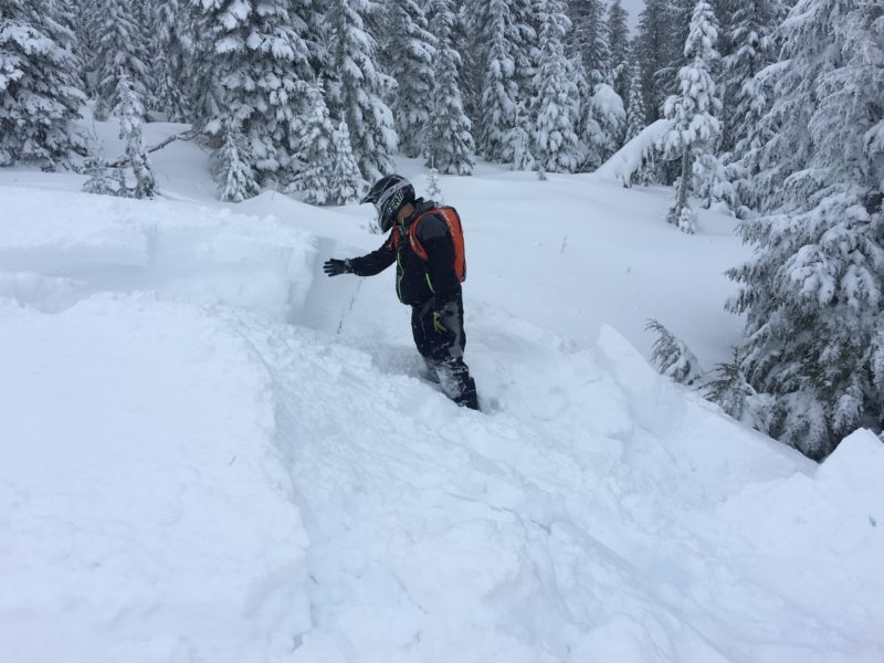
Snotel data for The southern Missions,  southern Swan, Rattlesnake and Central Bitterroot ranges shows a significant load over the last 36 hours. Mountain locations received between 1.0-2.4 inches of water and 10-20 inches of snow. Current mountain temps are in the 20’s and winds are calm at point six and in the low teens from the S at Deer Mountain.

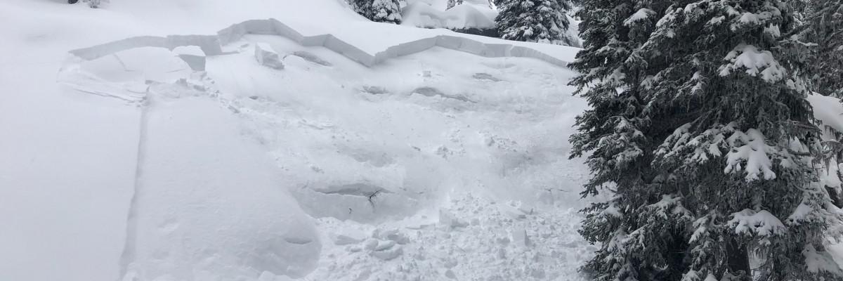
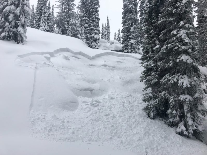
The avalanche warning is in effect due to a significant load of new snow on a weak snowpack. The southern Missions, southern Swan, Rattlesnake and Central Bitterroot ranges have been subject to the brunt of the storm and will have an increased likelihood of avalanche activity. We received multiple reports of human triggered avalanches in the advisory area and the surrounding mountains. Dangerous avalanche conditions exist and travel in avalanche terrain is not recommended. The snow will need time to adjust to the load and for the new snow to bond.

Avalanche and Weather Outlook

Light snow is expected to continue through the day today with a brief break before starting again late Thursday leading to cold temperatures for the weekend. Conditions will not change until loading stops and the snow can settle.

The next advisory will be issued Thursday December 21st.

Ski and ride safe.

READ FULL ADVISORY  

Problem 1 - Storm Slabs

  • TYPE

    storm-slabs

    Storm Slabs

    Release of a soft cohesive layer (a slab) of new snow which breaks within the storm snow or on the old snow surface. Storm-slab problems typically last between a few hours and few days. Storm-slabs that form over a persistent weak layer (surface hoar, depth hoar, or near-surface facets) may be termed Persistent Slabs or may develop into Persistent Slabs.

  • SIZE

    3-4

    1-2 (Small-Large)

    The potential size of avalanche resulting from this problem.

  • LIKELIHOOD

    Likelihood-6

    Likely/Very Likely

    The likelihood of an avalanche resulting from this problem.

  • ADDED DANGER

    Increased Slope Danger

    Increased/Added Danger

    There is an increased risk of avalanches on these slopes:

    N - North
    NE - Northeast
    E - East
    SE - Southeast
    S - South
    SW - Southwest
    W - West
    NW - Northwest

  • IMAGE

Between 1-2 feet of snow has accumulated in the northern advisory area.

Problem 2 - Persistent Slabs

  • TYPE

    persistent-slabs

    Persistent Slabs

    Release of a cohesive layer of soft to hard snow (a slab) in the middle to upper snowpack, when the bond to an underlying persistent weak layer breaks.  Persistent layers include: surface hoar, depth hoar, near-surface facets, or faceted snow. Persistent weak layers can continue to produce avalanches for days, weeks or even months, making them especially dangerous and tricky. As additional snow and wind events build a thicker slab on top of the persistent weak layer, this avalanche problem may develop into a Persistent, Deep-Slab.

  • SIZE

    4-5

    2 (Large)

    The potential size of avalanche resulting from this problem.

  • LIKELIHOOD

    Likelihood-6

    Likely/Very Likely

    The likelihood of an avalanche resulting from this problem.

  • ADDED DANGER

    Increased Slope Danger

    Increased/Added Danger

    There is an increased risk of avalanches on these slopes:

    N - North
    NE - Northeast
    E - East
    SE - Southeast
    S - South
    SW - Southwest
    W - West
    NW - Northwest

  • IMAGE

A significant load has been added to a weak snowpack.

FORECAST & OUTLOOK

  • Danger Trend

    increasing

    Increasing Danger

  • Area Forecast

    Snow

Snow followed by colder temperatures.

This information is the sole responsibility of the Forest Service and does not apply to operating ski areas. The avalanche danger rating expires at midnight tonight but the information can help you make a more informed decision regarding travel in avalanche terrain for the next few days.

Our advisory area includes National Forest System lands in the Bitterroot Mountains from Lost Trail Pass north to Granite Pass, the Rattlesnake Mountains north of Missoula and the Southern Swan and Mission Mountains near Seeley Lake, MT. Avalanche information for the Lookout Pass/St. Regis Basin area is available from the Idaho Panhandle Avalanche Center.