Posted:
Dec 21, 2017 @ 5:34 am

The avalanche warning has expired and the current avalanche danger is Considerable in the West Central Montana backcountry. Natural avalanches are possible and human triggered avalanches are likely across the region. Careful route finding and conservative decision-making are essential for backcountry travel today.

Good morning, this is Logan King with the West Central Montana Avalanche Center’s avalanche advisory for December 21st, 2017.  This danger rating does not apply to operating ski areas, expires at midnight tonight and is the sole responsibility of the U.S. Forest Service.

Weather and Snowpack

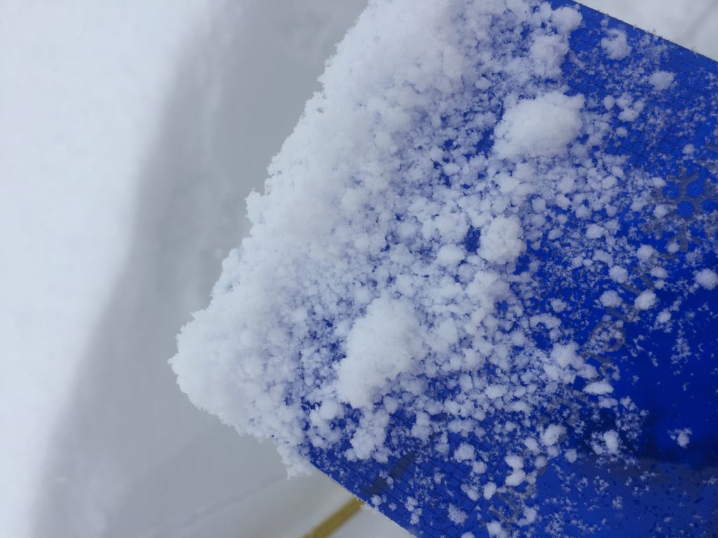
Snowfall has tapered off and the region received an additional 1-3 inches of snow overnight, adding another .1-.3 inches of water to the snowpack. Winds this morning at Deer Mountain are 7 mph gusting to 11 mph from the WNW. Temperatures early this morning are in the teens to low twenties.

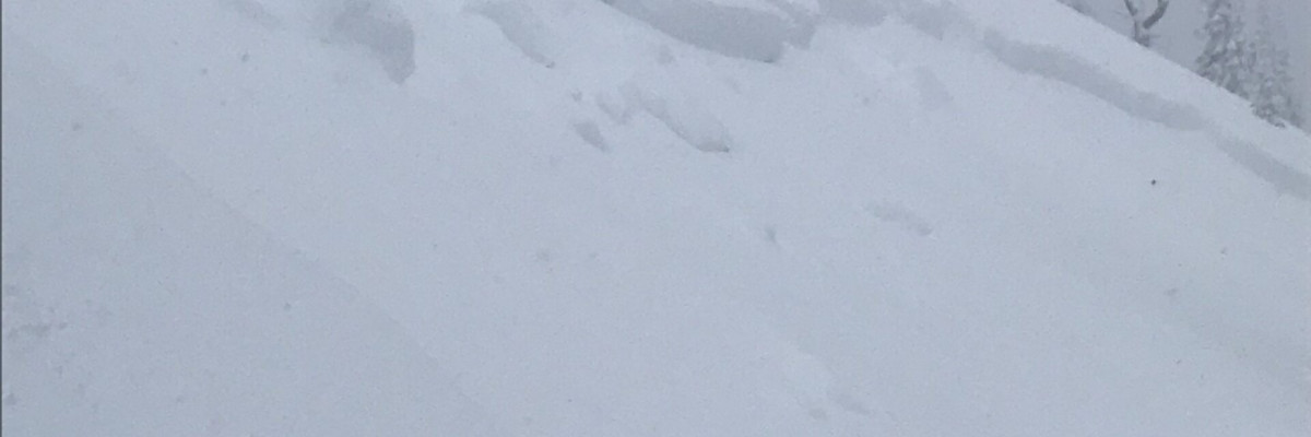
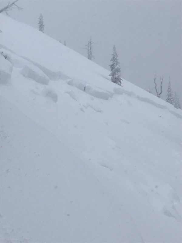
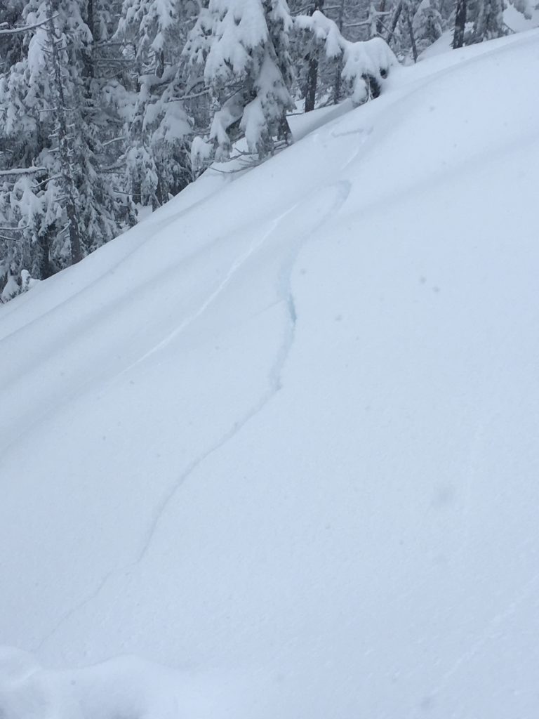
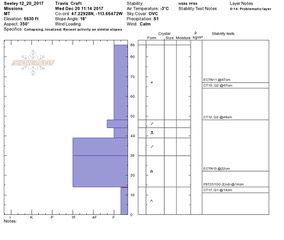
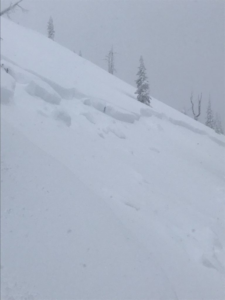
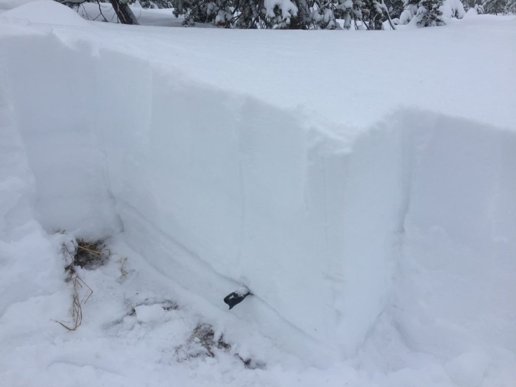
Travis and I rode in Seeley Lake yesterday and Tim was in the Rattlesnake. We found a significant amount of new snow that lead to numerous natural and human triggered avalanches over the last few days. Widespread collapsing/whumphing was observed along with shooting cracks that traveled long distances. Avalanche activity is leveling off as the new snow bonds and the weak layers are adjusting to the load.

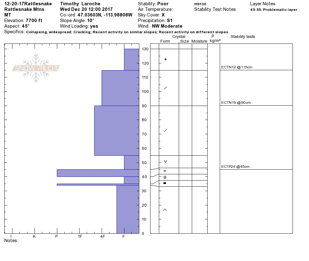
The primary avalanche problem today is persistent slabs. There are multiple layers of facets throughout the advisory area. Of greatest concern are the facets associated with the Thanksgiving crust. These facets were very reactive during the storm cycle and were responsible for the majority of large avalanches seen over the last few days. The persistent weak layers will continue to be sensitive to triggers and will produce large avalanches. Cautious evaluation and identification of this layer will be vital before committing to avalanche terrain.

The secondary avalanche concern today will be wind slabs. Winds were relatively calm with the storm but Tim reported finding beefy slabs that would result in large high consequence avalanches. Wind is forecast to increase today and through tonight as a cold front pushes into the region. Avoid steep terrain that appears to be wind loaded.

Storm Slabs are the final concern today. The storm slabs are bonding to the old snow surface and are becoming less reactive. Take the time to evaluate if the new/old snow interface is bonding.

Avalanche and Weather Outlook

Snow is expected to start this afternoon and continue into Friday as a cold front moves in dropping temperatures below zero. Conditions look to remain about the same as long as too much snow isn’t added too quickly to the snowpack.

If you are out in the backcountry, please send us your observation, these are very helpful in producing the advisory. A weather update will be issued Friday. Ski and ride safe.

READ FULL ADVISORY  

Problem 1 - Persistent Slabs

  • TYPE

    persistent-slabs

    Persistent Slabs

    Release of a cohesive layer of soft to hard snow (a slab) in the middle to upper snowpack, when the bond to an underlying persistent weak layer breaks.  Persistent layers include: surface hoar, depth hoar, near-surface facets, or faceted snow. Persistent weak layers can continue to produce avalanches for days, weeks or even months, making them especially dangerous and tricky. As additional snow and wind events build a thicker slab on top of the persistent weak layer, this avalanche problem may develop into a Persistent, Deep-Slab.

  • SIZE

    5-6

    2-3 (Large)

    The potential size of avalanche resulting from this problem.

  • LIKELIHOOD

    Likelihood-5

    Likely

    The likelihood of an avalanche resulting from this problem.

  • IMAGE

The facets associated with the Thanksgiving crust have been very reactive under the new load and will continue to be a concern.

Problem 2 - Wind Slabs

  • TYPE

    wind-slabs

    Wind Slabs

    Release of a cohesive layer of snow (a slab) formed by the wind.  Wind typically erodes snow from the upwind sides of terrain features and deposits snow on the downwind side.  Wind slabs are often smooth and rounded and sometimes sound hollow, and can range from soft to hard. Wind slabs that form over a persistent weak layer (surface hoar, depth hoar, or near-surface facets) may be termed Persistent Slabs or may develop into Persistent Slabs.

  • SIZE

    3-4

    1-2 (Small-Large)

    The potential size of avalanche resulting from this problem.

  • LIKELIHOOD

    Likelihood-4

    Possible/Likely

    The likelihood of an avalanche resulting from this problem.

  • ADDED DANGER

    Increased Slope Danger

    Increased/Added Danger

    There is an increased risk of avalanches on these slopes:

    E - East
    SE - Southeast
    S - South
    SW - Southwest

Wind slabs are large and can result in high consequence avalanches.

Problem 3 - Storm Slabs

  • TYPE

    storm-slabs

    Storm Slabs

    Release of a soft cohesive layer (a slab) of new snow which breaks within the storm snow or on the old snow surface. Storm-slab problems typically last between a few hours and few days. Storm-slabs that form over a persistent weak layer (surface hoar, depth hoar, or near-surface facets) may be termed Persistent Slabs or may develop into Persistent Slabs.

  • SIZE

    3-4

    1-2 (Small-Large)

    The potential size of avalanche resulting from this problem.

  • LIKELIHOOD

    Likelihood-4

    Possible/Likely

    The likelihood of an avalanche resulting from this problem.

  • IMAGE

The storm slab is bonding to the new snow but should still be treated with caution.

VIDEO

FORECAST & OUTLOOK

Snow looks to pick up again this evening and into Friday. Temperatures will drop as a cold front moves in.

This information is the sole responsibility of the Forest Service and does not apply to operating ski areas. The avalanche danger rating expires at midnight tonight but the information can help you make a more informed decision regarding travel in avalanche terrain for the next few days.

Our advisory area includes National Forest System lands in the Bitterroot Mountains from Lost Trail Pass north to Granite Pass, the Rattlesnake Mountains north of Missoula and the Southern Swan and Mission Mountains near Seeley Lake, MT. Avalanche information for the Lookout Pass/St. Regis Basin area is available from the Idaho Panhandle Avalanche Center.