Posted:
Dec 23, 2017 @ 5:24 am

The avalanche danger for the West Central Montana backcountry is Considerable. Human triggered avalanches are likely. Careful snowpack and terrain evaluation remain important for safe backcountry travel.

Good morning, this is Logan King with the West Central Montana Avalanche Center’s avalanche advisory for December 23rd, 2017.  This danger rating does not apply to operating ski areas, expires at midnight tonight and is the sole responsibility of the U.S. Forest Service.

Weather and Snowpack

An arctic cold front is flooding into the region dropping mountain temperatures to around zero in the northern portion of the advisory area. Further south, temperatures are in the low teens this morning. Scattered low density snow continues to fall and 1-4 inches have accumulated overnight. Winds are light this morning from the N.

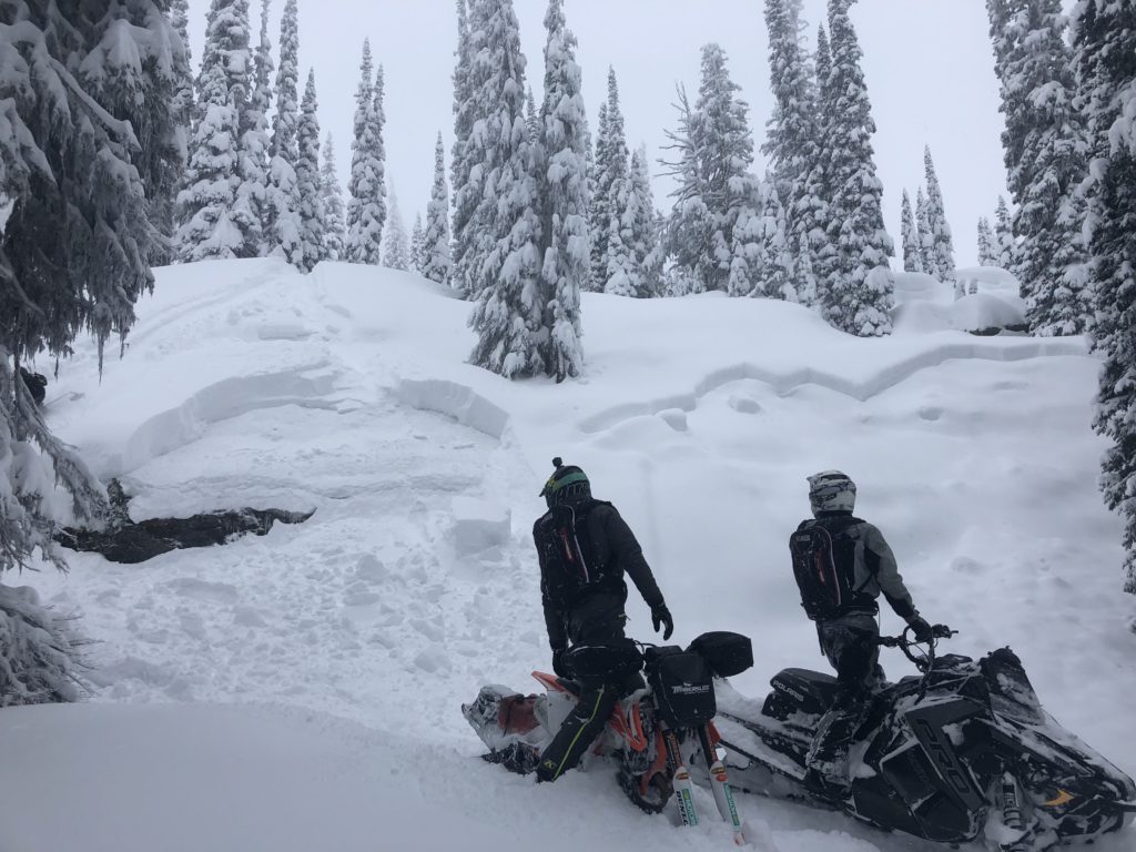
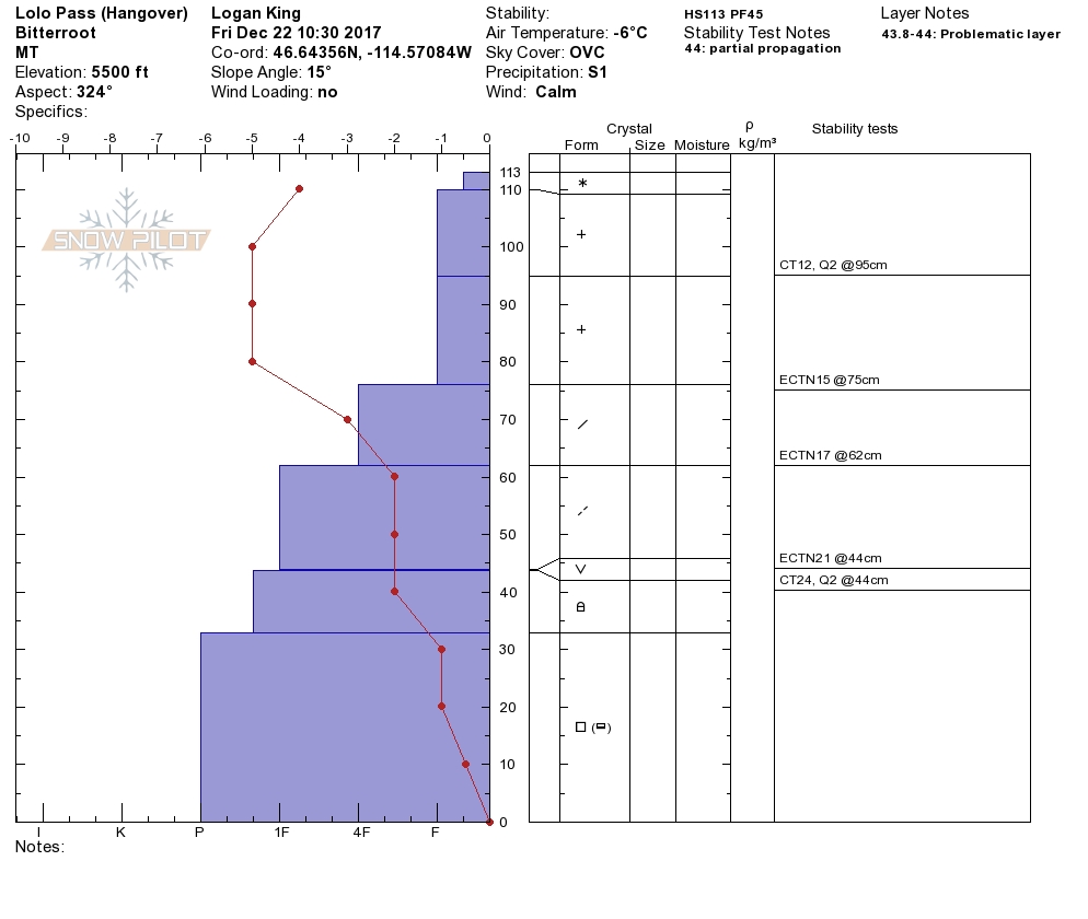
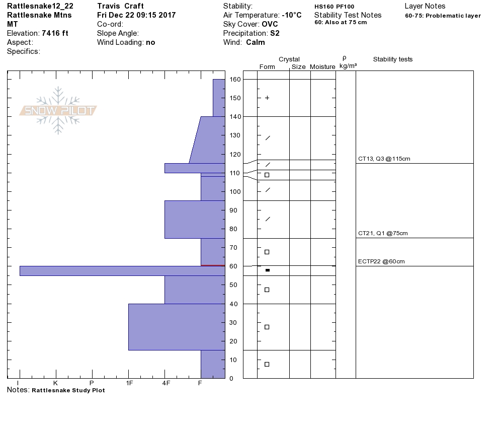
Travis was in the Rattlesnake yesterday and I was up at Lolo Pass. We both found the primary concern to be persistent weak layers.

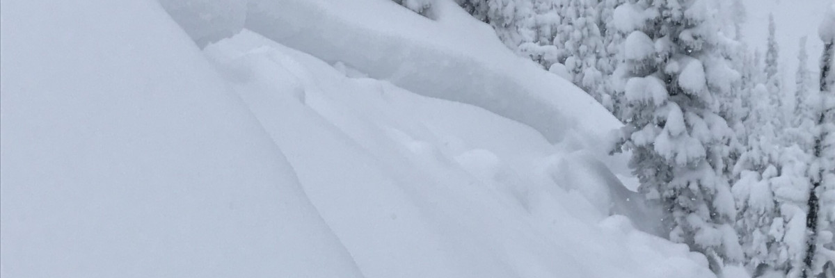
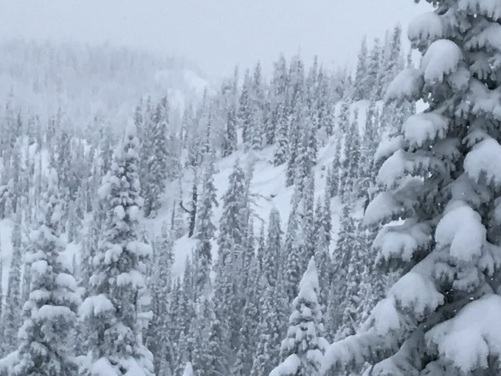
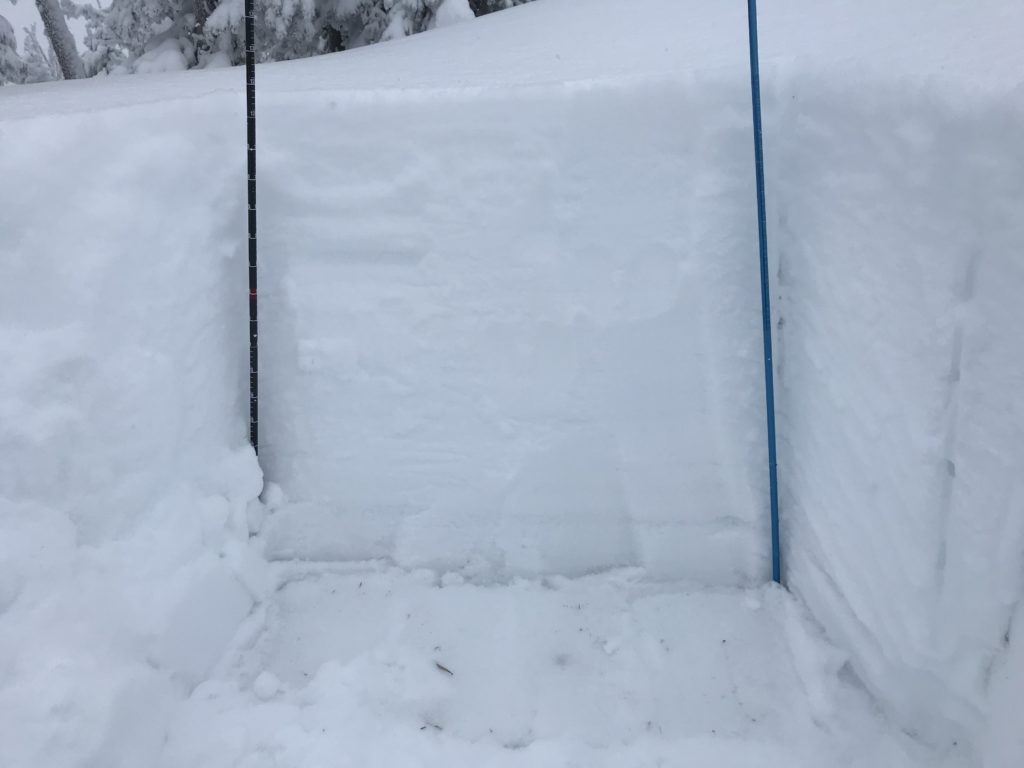
The primary avalanche problem today is persistent slabs. There are two distinct persistent weak layers of concern. Above 6,000 feet facets on the Thanksgiving crust continue to cause significant avalanche problems as indicated by multiple natural releases observed on this layer yesterday. Below 6,000 feet there is a spotty layer of buried surface hoar. You will need to dig and see if these layers are present and reactive. Carefully evaluate the snowpack before exposing yourself to avalanche terrain.

Loose snow avalanches are the secondary concern today. Loose snow avalanches are problematic due to the potential to step down and trigger a larger slide on one of the persistent weak layers or in steep terrain where terrain traps are present. Carefully identify features of concern and the resulting consequences of getting caught in a loose snow slide.

Avalanche and Weather Outlook

Snow will taper off today giving way to frigid temperatures before the next cycle of snow begins late Sunday. Avalanche conditions will not change much through the weekend.

If you are out in the backcountry, please send us your observations, these are very helpful in producing the advisory. Ski and ride safe.

READ FULL ADVISORY  

Problem 1 - Persistent Slabs

  • TYPE

    persistent-slabs

    Persistent Slabs

    Release of a cohesive layer of soft to hard snow (a slab) in the middle to upper snowpack, when the bond to an underlying persistent weak layer breaks.  Persistent layers include: surface hoar, depth hoar, near-surface facets, or faceted snow. Persistent weak layers can continue to produce avalanches for days, weeks or even months, making them especially dangerous and tricky. As additional snow and wind events build a thicker slab on top of the persistent weak layer, this avalanche problem may develop into a Persistent, Deep-Slab.

  • SIZE

    5-6

    2-3 (Large)

    The potential size of avalanche resulting from this problem.

  • LIKELIHOOD

    Likelihood-5

    Likely

    The likelihood of an avalanche resulting from this problem.

There are two different persistent weak layers dependent on elevation in the snowpack that will result in high consequence avalanche potential.

Problem 2 - Loose Dry

  • TYPE

    loose-dry

    Loose Dry

    Release of wet unconsolidated snow or slush. These avalanches typically occur within layers of wet snow near the surface of the snowpack, but they may quickly gouge into lower snowpack layers. Like Loose-Dry Avalanches,they start at a point and entrain snow as they move downhill, forming a fan-shaped avalanche. They generally move slowly, but can contain enough mass to cause significant damage to trees, cars or buildings. Other names for loose-wet avalanches include point-release avalanches or sluffs. Loose-wet avalanches can trigger slab avalanches that break into deeper snow layers.

  • SIZE

    1-2

    < 1 (Small)

    The potential size of avalanche resulting from this problem.

  • LIKELIHOOD

    Likelihood-4

    Possible/Likely

    The likelihood of an avalanche resulting from this problem.

Loose snow avalanches where terrain traps increase the consequences of getting caught in a slide or have the potential to step down to layers deeper in the snowpack will be a concern today.

VIDEO

FORECAST & OUTLOOK

  • Danger Trend

    same

    Same Danger

  • Area Forecast

    Cold

Arctic air will bring cold temperatures through the weekend before snow returns late Sunday.

This information is the sole responsibility of the Forest Service and does not apply to operating ski areas. The avalanche danger rating expires at midnight tonight but the information can help you make a more informed decision regarding travel in avalanche terrain for the next few days.

Our advisory area includes National Forest System lands in the Bitterroot Mountains from Lost Trail Pass north to Granite Pass, the Rattlesnake Mountains north of Missoula and the Southern Swan and Mission Mountains near Seeley Lake, MT. Avalanche information for the Lookout Pass/St. Regis Basin area is available from the Idaho Panhandle Avalanche Center.