Posted:
Dec 26, 2017 @ 6:44 am

The current avalanche danger is Considerable in the West Central Montana backcountry.  This means careful snowpack evaluation, cautious route-finding, and conservative decision-making are essential to recreate today.

Good morning, this is Travis Craft with the West Central Montana Avalanche Center’s avalanche advisory for December 26, 2017.  This danger rating does not apply to operating ski areas, expires at midnight tonight and is the sole responsibility of the U.S. Forest Service.

Weather and Snowpack

Mountain temperatures range from -11 F to 23 F in the region.  In the Bitterroot winds are 3 mph with gusts of 5 out of the W.  In the northern part of the advisory area, at Point Six, winds are reading 6 mph with gusts of 22 mph out of the W.  The forecast area received 3 to 6 inches of new snow in the last 24 hours.

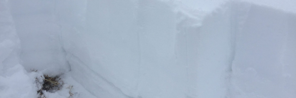
We are still getting propagation in our pit tests throughout the advisory area.  There was  public observation of propagation in a pit near Lolo pass. See the full observation here.

The primary avalanche problem is persistent slabs. The new snow will stress our weak layers.  We have poor snowpack structure throughout our advisory area. This means careful snowpack evaluation, cautious route-finding, and conservative decision-making are essential to recreate today.  Look for clues from the snowpack, shooting cracks and localized collapsing.  Dig a pit on low angle terrain in a safe spot out of runout zones to see how the layers are adjusting to the new load.

Avalanche and Weather Outlook

Today will be dry and then by Wednesday snow will move back into the forecast.  The avalanche danger will stay the same until more snow comes to our area.

I will issue a weather update tomorrow.

Ski and ride safe.

READ FULL ADVISORY  

Problem 1 - Persistent Slabs

  • TYPE

    persistent-slabs

    Persistent Slabs

    Release of a cohesive layer of soft to hard snow (a slab) in the middle to upper snowpack, when the bond to an underlying persistent weak layer breaks.  Persistent layers include: surface hoar, depth hoar, near-surface facets, or faceted snow. Persistent weak layers can continue to produce avalanches for days, weeks or even months, making them especially dangerous and tricky. As additional snow and wind events build a thicker slab on top of the persistent weak layer, this avalanche problem may develop into a Persistent, Deep-Slab.

  • SIZE

    4-5

    2 (Large)

    The potential size of avalanche resulting from this problem.

  • LIKELIHOOD

    Likelihood-5

    Likely

    The likelihood of an avalanche resulting from this problem.

The two layers of concern are the buried surface hoar and the near surface facets on top of the Thanksgiving crust.  Dig a pit to assess how reactive these layers are before committing to any slope over 30 degrees.

FORECAST & OUTLOOK

  • Danger Trend

    same

    Same Danger

  • Area Forecast

    Cold

This is the last dry day for the week.  Look for moisture to start entering the area by tomorrow.  See the whole forecast here.


This information is the sole responsibility of the Forest Service and does not apply to operating ski areas. The avalanche danger rating expires at midnight tonight but the information can help you make a more informed decision regarding travel in avalanche terrain for the next few days.

Our advisory area includes National Forest System lands in the Bitterroot Mountains from Lost Trail Pass north to Granite Pass, the Rattlesnake Mountains north of Missoula and the Southern Swan and Mission Mountains near Seeley Lake, MT. Avalanche information for the Lookout Pass/St. Regis Basin area is available from the Idaho Panhandle Avalanche Center.