Posted:
Dec 28, 2017 @ 6:54 am

The current avalanche danger is CONSIDERABLE in the West central Montana backcountry on wind loaded slopes. This means careful snowpack evaluation, cautious route-finding, and conservative decision-making are essential to recreate today.  All other slopes the danger is Moderate.  With changing weather conditions, the avalanche danger will rise.

Good morning, this is Travis Craft with the West Central Montana Avalanche Center’s avalanche advisory for December 28, 2017.  This danger rating does not apply to operating ski areas, expires at midnight tonight and is the sole responsibility of the U.S. Forest Service.

Weather and Snowpack

Mountain temperatures range from 16 F to 32 F in the region.  In the Bitterroot winds are 4 mph with gusts of 5 out of the SSW.  In the northern part of the advisory area, at Point Six, winds are reading 20 mph with gusts of 30 mph out of the W.  The forecast area received 3 to 8 inches of new snow in the last 24 hours.

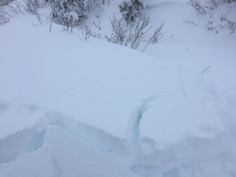
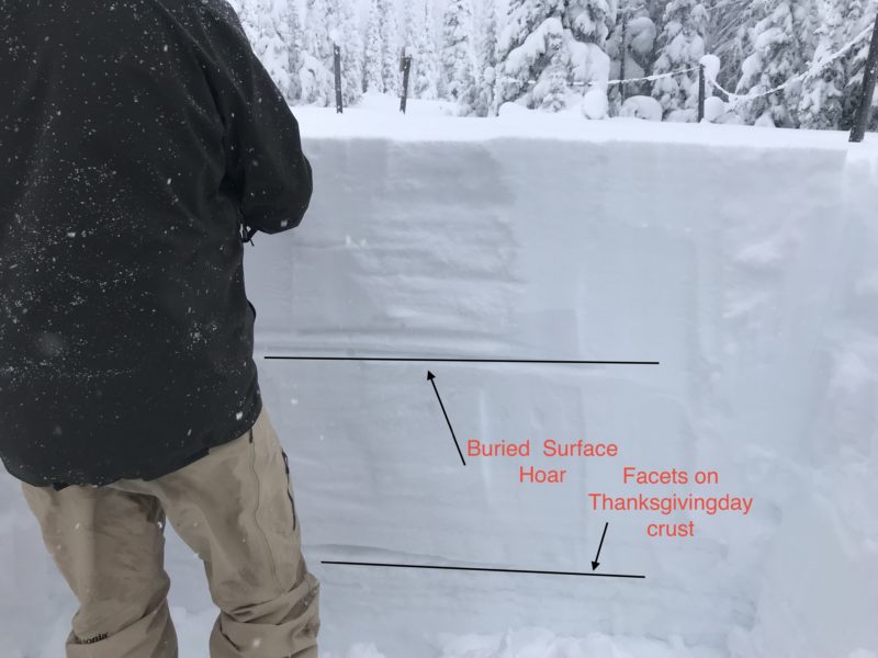
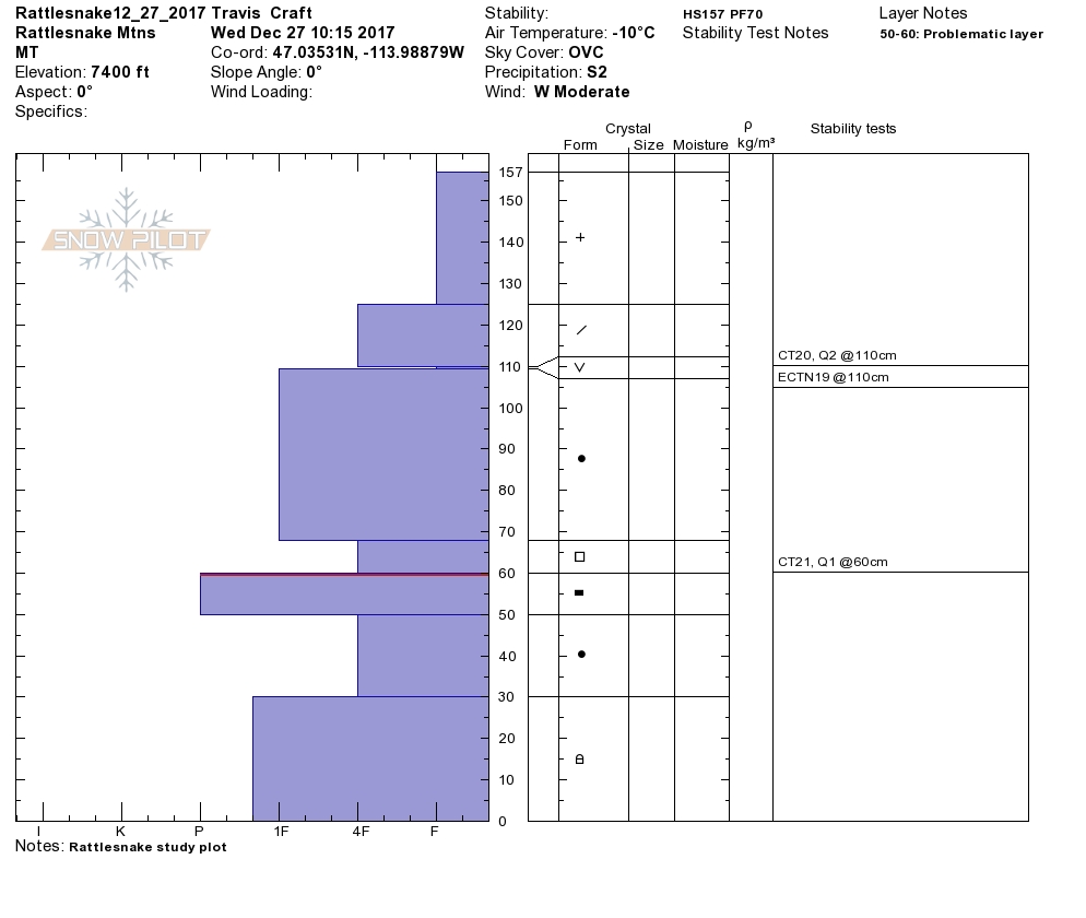
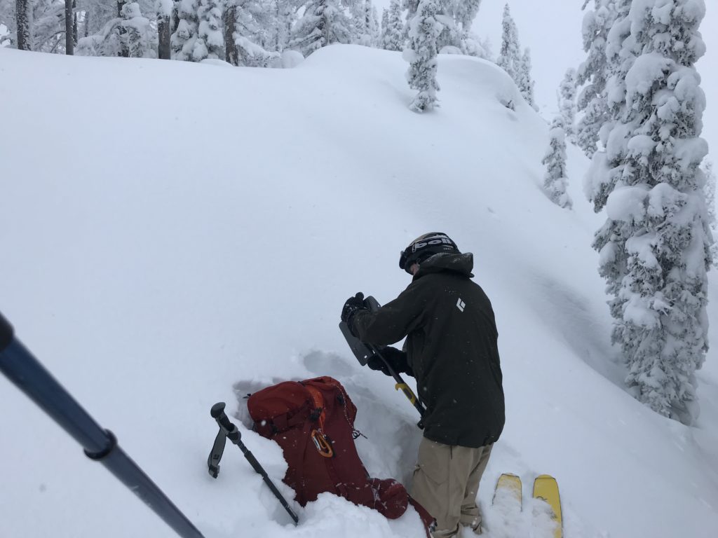
Steve and I toured in the Rattlesnake yesterday.  We did get propagation on the Thanksgiving day crust.  We did not get any collapsing or shooting cracks.  We saw active transport of snow creating wind slabs.  We have public observations from Gash Point in the Bitterroot and Lolo Pass.  John Lehrman from Downing Mountain Lodge in the Central Bitterroot is worried about the tipping point that the facets on the Thanksgiving crust can take.

The primary avalanche problem in the Rattlesnake, southern Swans and southern Missions is wind slabs.  These slabs will be sensitive to human triggers and grow in size throughout the day.  The Bitterroot range will see this problem develop with wind speeds increasing in the storm.

The Primary avalanche problem in the Bitterroot is storm slabs.  These slabs are increasing in size and are coming in upside-down.  These slabs will be sensitive to human triggers and will grow throughout the day.  The Rattlesnake,  southern Swans, and southern Missions storm slabs will develop during the day with the addition of more snow.

The second avalanche problem throughout the advisory area is persistent slabs.  These layers will become more reactive to triggers with the addition of new snow.  We have poor snowpack structure throughout our advisory area. Look for clues from the snowpack shooting cracks and localized collapsing.  Dig a pit on low angle terrain in a safe spot out of runout zones to see how the layers are adjusting to the new load.

Avalanche and Weather Outlook

The bottom line is the avalanche danger will increase today with new snow and wind.  Pay close attention to changing conditions and reevaluate terrain choices throughout the day.  Careful snowpack evaluation, cautious route-finding, and conservative decision-making are essential to recreate today. A potent storm is entering our area today.  Here is a link to the discussion.

If you are out in the backcountry, please send us your observation, these are very helpful in producing the advisory. I will issue a weather update tomorrow  December 29, 2017.

Ski and ride safe.

READ FULL ADVISORY  

Problem 1 - Wind Slabs

  • TYPE

    wind-slabs

    Wind Slabs

    Release of a cohesive layer of snow (a slab) formed by the wind.  Wind typically erodes snow from the upwind sides of terrain features and deposits snow on the downwind side.  Wind slabs are often smooth and rounded and sometimes sound hollow, and can range from soft to hard. Wind slabs that form over a persistent weak layer (surface hoar, depth hoar, or near-surface facets) may be termed Persistent Slabs or may develop into Persistent Slabs.

  • SIZE

    3-4

    1-2 (Small-Large)

    The potential size of avalanche resulting from this problem.

  • LIKELIHOOD

    Likelihood-4

    Possible/Likely

    The likelihood of an avalanche resulting from this problem.

  • IMAGE

The Missions, Swans and Rattlesnake have had moderate to strong winds with new snow available for transport.  The Bitterroot has had calm winds.  Look for winds to increase with the storm.  Look for rounded pillows of snow near ridgelines and recognize signs of instability such as cracking in the surface snow.  Look for cross-loaded terrain as well as ridge tops.

Problem 2 - Storm Slabs

  • TYPE

    storm-slabs

    Storm Slabs

    Release of a soft cohesive layer (a slab) of new snow which breaks within the storm snow or on the old snow surface. Storm-slab problems typically last between a few hours and few days. Storm-slabs that form over a persistent weak layer (surface hoar, depth hoar, or near-surface facets) may be termed Persistent Slabs or may develop into Persistent Slabs.

  • SIZE

    3-4

    1-2 (Small-Large)

    The potential size of avalanche resulting from this problem.

  • LIKELIHOOD

    Likelihood-3

    Possible

    The likelihood of an avalanche resulting from this problem.

  • IMAGE

Storm slabs are the primary concern in the Bitterroot. This storm is upside-down(cold light snow with heavy wet snow on top).  Look for shooting cracks to identify this problem.

Problem 3 - Persistent Slabs

  • TYPE

    persistent-slabs

    Persistent Slabs

    Release of a cohesive layer of soft to hard snow (a slab) in the middle to upper snowpack, when the bond to an underlying persistent weak layer breaks.  Persistent layers include: surface hoar, depth hoar, near-surface facets, or faceted snow. Persistent weak layers can continue to produce avalanches for days, weeks or even months, making them especially dangerous and tricky. As additional snow and wind events build a thicker slab on top of the persistent weak layer, this avalanche problem may develop into a Persistent, Deep-Slab.

  • SIZE

    4-5

    2 (Large)

    The potential size of avalanche resulting from this problem.

  • LIKELIHOOD

    Likelihood-3

    Possible

    The likelihood of an avalanche resulting from this problem.

  • IMAGE

With the addition of new snow look for the persistent weak layers in our snowpack to become more reactive. The two layers of concern are the buried surface hoar and the near surface facets on top of the Thanksgiving crust.  Dig a pit to assess how reactive these layers are before committing to any slope over 30 degrees.

VIDEO

Observations 12/27/2017

Observations 12/27/2017

FORECAST & OUTLOOK

A potent storm is entering our area today. The  avalanche danger will increase with this storm.  Pay close attention to changing conditions.  Here is the link to the discussion.

This information is the sole responsibility of the Forest Service and does not apply to operating ski areas. The avalanche danger rating expires at midnight tonight but the information can help you make a more informed decision regarding travel in avalanche terrain for the next few days.

Our advisory area includes National Forest System lands in the Bitterroot Mountains from Lost Trail Pass north to Granite Pass, the Rattlesnake Mountains north of Missoula and the Southern Swan and Mission Mountains near Seeley Lake, MT. Avalanche information for the Lookout Pass/St. Regis Basin area is available from the Idaho Panhandle Avalanche Center.