Posted:
Jan 12, 2018 @ 5:48 am

An avalanche warning is in effect for the West central Montana backcountry.  The current avalanche danger is HIGH.  Very dangerous avalanche conditions exist.  Travel in avalanche terrain is not recommended. Large human triggered avalanches are very likely.

This is Logan King with an avalanche warning for Friday, January 12th, 2017.  This avalanche warning is valid for 24 hours. The avalanche warning will either be extended or terminated at 0600 Saturday January 13th.

This danger rating does not apply to operating ski areas and is the sole responsibility of the U.S. Forest Service.

 Weather and Snowpack

A storm continues to wallop the region. Over an inch of SWE (snow water equivalent) has been added to the snowpack in the last 24 hours across the region. More than a foot of snow has fallen through the entire advisory area adding 1.1-1.6 inches of water since yesterday morning alone. This bring 2 day storm totals for some locations to over 3 inches of water already.

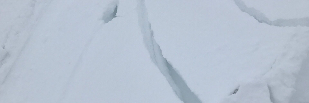
An extremely heavy load of snow has been added to the snowpack. Avalanche activity will be widespread and has the potential to travel long distances and into flat terrain. Avoid traveling in or near avalanche terrain.

The primary avalanche concern is storm slabs. There is no denying that a hefty load of snow and water have been added to the snowpack but this load is resulting in widespread instability. Adding fuel to the fire are weak layers in the snowpack. Snow is falling on rain and sun crusts or buried surface hoar further enhancing the likelihood of avalanches. A storm that adds this much load this quickly will have the ability wake up the deep persistent layers. The Thanksgiving crust has the potential to become active again, resulting in extremely large avalanches.

The take home today is to avoid traveling in or around avalanche terrain. Conditions will be touchy for the next 24 hours at a minimum. A stressed snowpack, weak layers, bed surfaces, and a deep instability are more than enough evidence to steer clear of avalanche terrain for a few days.

Ski and ride safe.

READ FULL ADVISORY  

Problem 1 - Storm Slabs

  • TYPE

    storm-slabs

    Storm Slabs

    Release of a soft cohesive layer (a slab) of new snow which breaks within the storm snow or on the old snow surface. Storm-slab problems typically last between a few hours and few days. Storm-slabs that form over a persistent weak layer (surface hoar, depth hoar, or near-surface facets) may be termed Persistent Slabs or may develop into Persistent Slabs.

  • SIZE

    5-6

    2-3 (Large)

    The potential size of avalanche resulting from this problem.

  • LIKELIHOOD

    Likelihood-7

    Very Likely

    The likelihood of an avalanche resulting from this problem.

Consecutive days of 1+ inches of water and around a foot of snow each day are creating widespread instability.

Problem 2 - Persistent Slabs

  • TYPE

    persistent-slabs

    Persistent Slabs

    Release of a cohesive layer of soft to hard snow (a slab) in the middle to upper snowpack, when the bond to an underlying persistent weak layer breaks.  Persistent layers include: surface hoar, depth hoar, near-surface facets, or faceted snow. Persistent weak layers can continue to produce avalanches for days, weeks or even months, making them especially dangerous and tricky. As additional snow and wind events build a thicker slab on top of the persistent weak layer, this avalanche problem may develop into a Persistent, Deep-Slab.

  • SIZE

    7-8

    3-4 (Very Large)

    The potential size of avalanche resulting from this problem.

  • LIKELIHOOD

    Likelihood-5

    Likely

    The likelihood of an avalanche resulting from this problem.

Locations with buried surface hoar will be extremely sensitive today. There is an increased risk of avalanches stepping down to the Thanksgiving crust and being very large.

FORECAST & OUTLOOK

  • Danger Trend

    increasing

    Increasing Danger

  • Area Forecast

    Snow

Snow will continue to fall through the day today and into Saturday. Snowfall rates will begin to slowly decrease into the weekend.

This information is the sole responsibility of the Forest Service and does not apply to operating ski areas. The avalanche danger rating expires at midnight tonight but the information can help you make a more informed decision regarding travel in avalanche terrain for the next few days.

Our advisory area includes National Forest System lands in the Bitterroot Mountains from Lost Trail Pass north to Granite Pass, the Rattlesnake Mountains north of Missoula and the Southern Swan and Mission Mountains near Seeley Lake, MT. Avalanche information for the Lookout Pass/St. Regis Basin area is available from the Idaho Panhandle Avalanche Center.