Posted:
Jan 16, 2018 @ 6:24 am

The current avalanche danger is MODERATE in the west central Montana backcountry. Human triggered avalanches are possible.  Heightened avalanche conditions exist on specific terrain features.  Evaluate snow and terrain carefully and identify features of concern.

Good morning, this is Travis Craft with the West Central Montana Avalanche Center’s avalanche advisory for January 15, 2018.  This danger rating does not apply to operating ski areas, expires at midnight tonight and is the sole responsibility of the U.S. Forest Service.

Weather and Snowpack

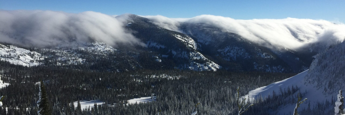
Mountain temperatures range from 20 F 31 F in the region.  In the Bitterroot winds are 17 mph with gusts of 22 out of the SE.  In the northern part of the advisory area, winds are reading 6 mph with gusts of 8 mph out of the ESE.  The forecast area received 0 to 1 inch of new snow in the last 24 hours.

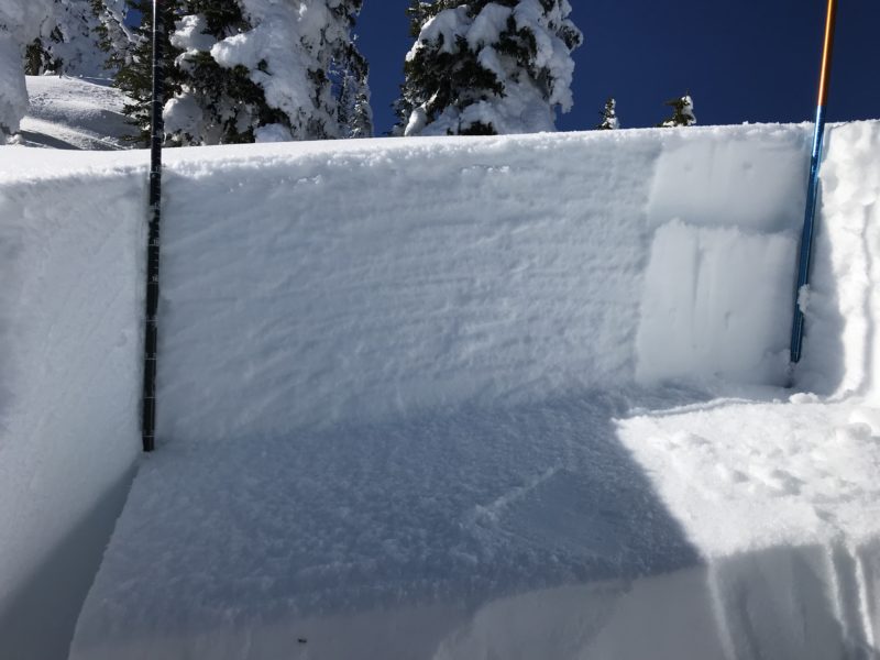
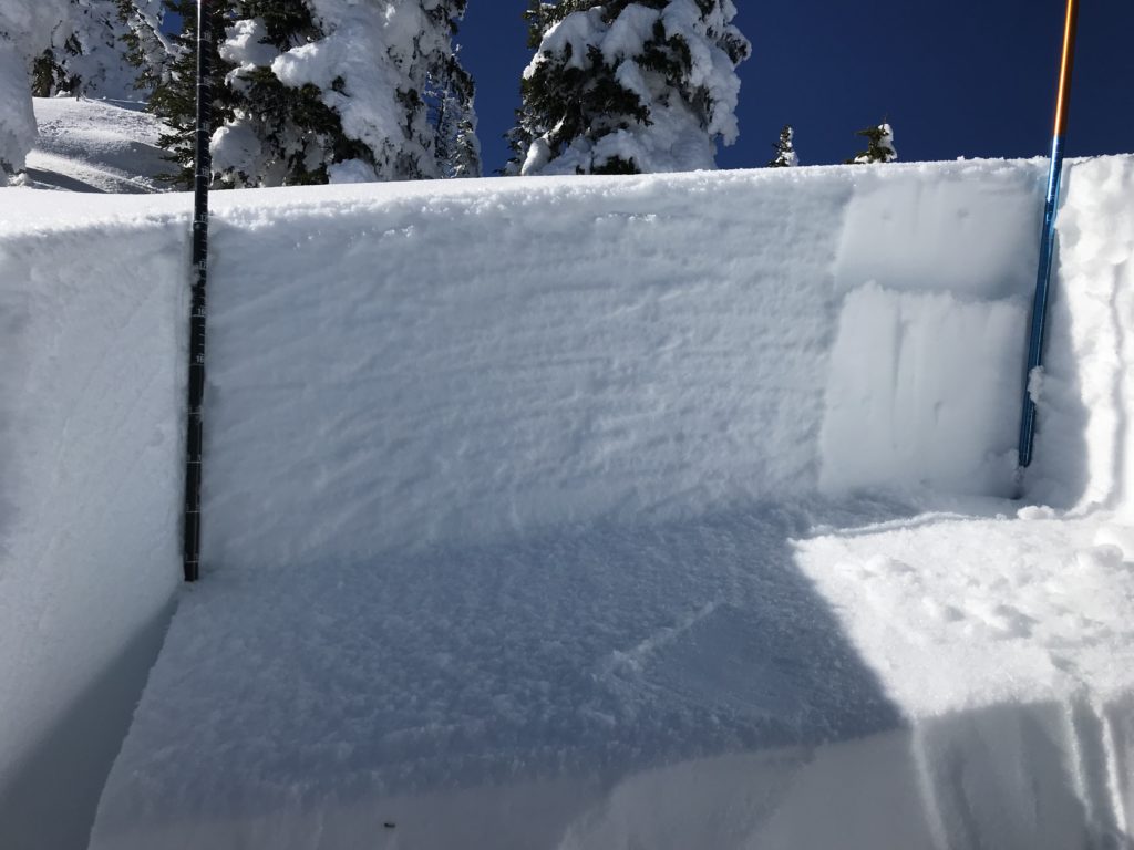
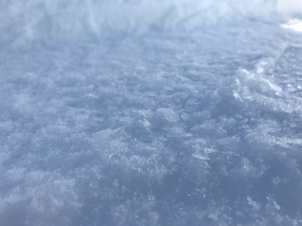
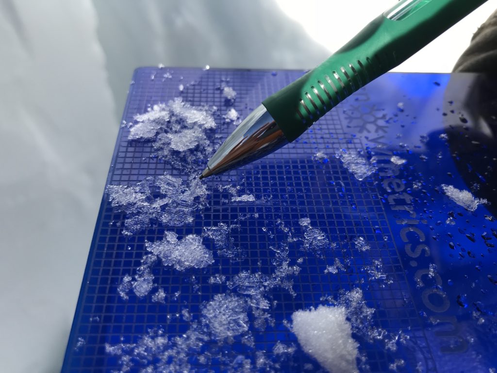
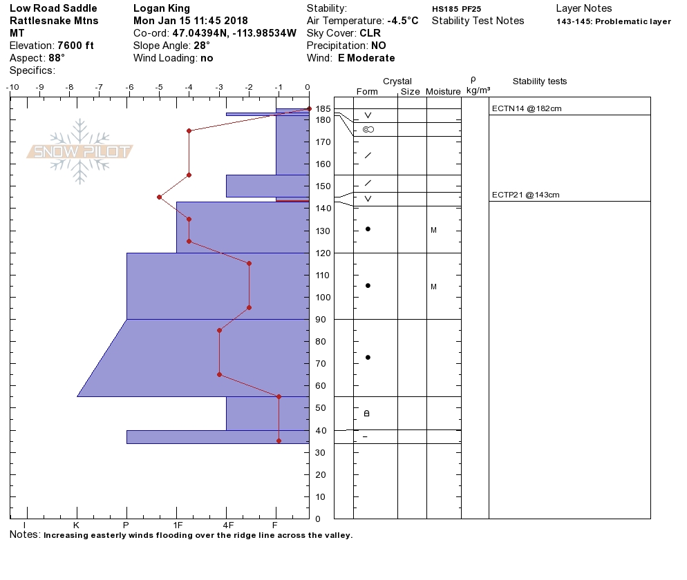
Logan and I toured in the Rattlesnake yesterday.  We found small wind loaded slopes.  We discovered a layer of buried surface hoar that propagated in pit tests.  We saw several loose wet events from days past and yesterday.  We have observations from the southern Bitterroot of small wind slabs and loose wet releases in the afternoon.  The storm slabs have healed.  The facets on top of the Thanksgiving crust are buried very deep in our snowpack and are unreactive in snow pit tests.  Avoid likely trigger points(near cliffs and rock bands) where the snowpack is shallower to decrease the possibility of triggering this layer.

The primary avalanche problem is persistent slabs.  There is a layer of buried surface hoar in all our ranges that is reactive in pit tests,  not every slope or aspect will have it.  The only way to find this layer is to dig a pit and see if this layer is present.

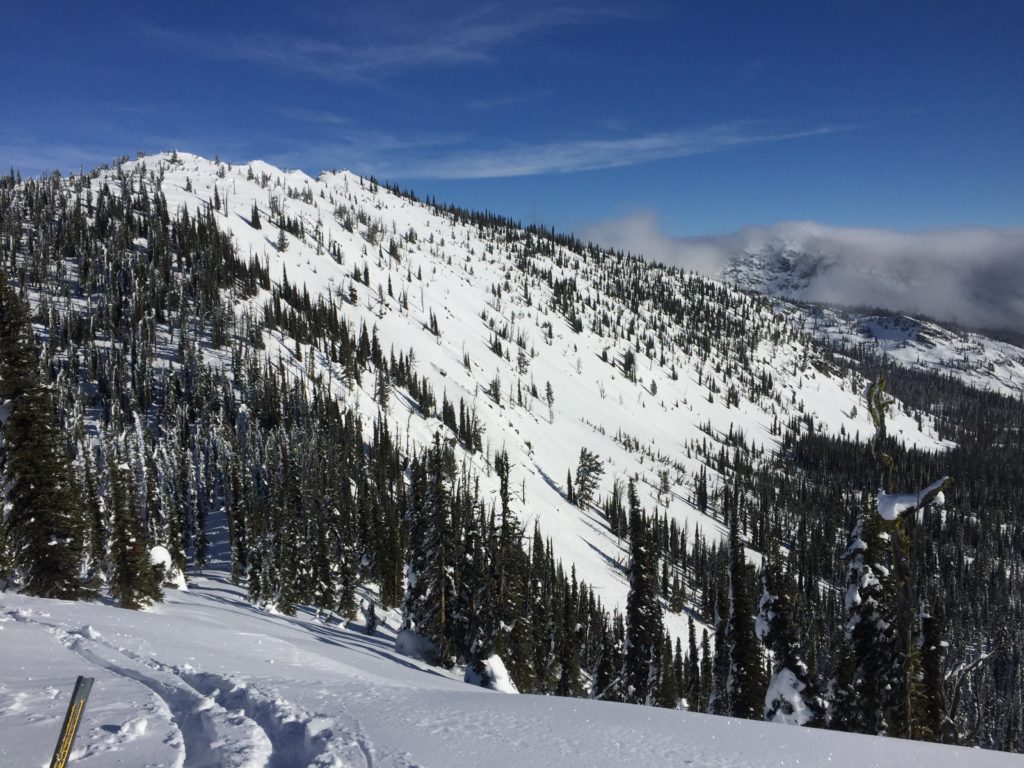
The second avalanche problem is wind slabs. Leeward slopes have small wind slabs. Look for rounded pillows of snow near ridgelines and cross-loaded slopes. Recognize signs of instability such as cracking in the surface snow.  These slabs will be sensitive to human triggers.

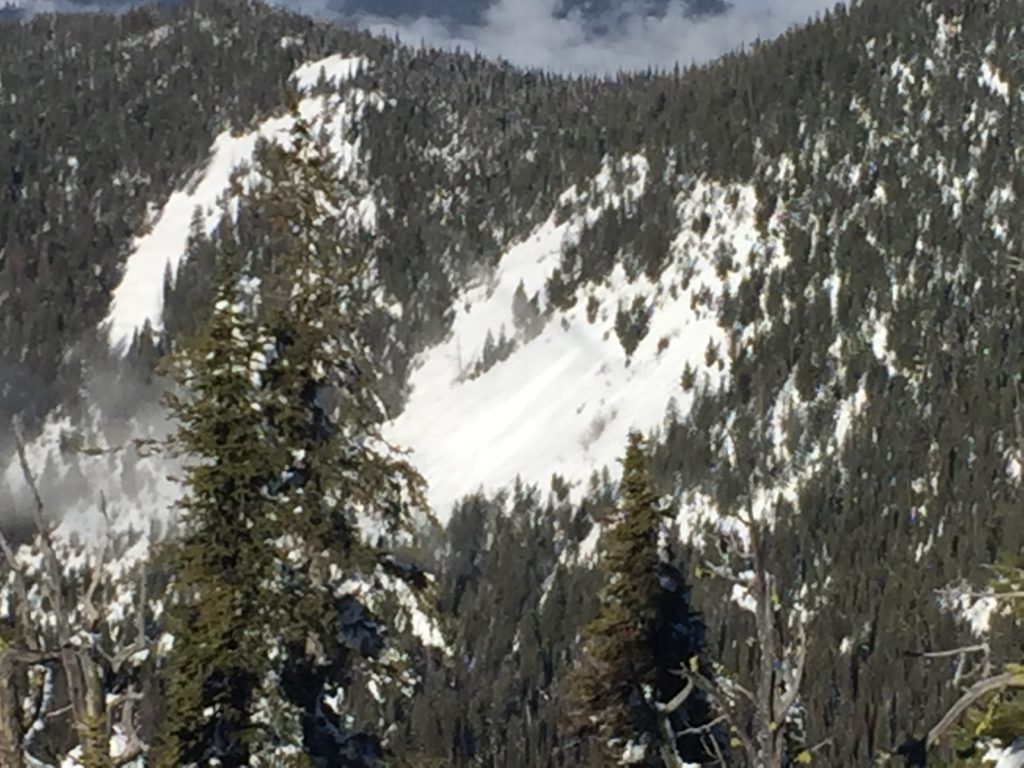
The final avalanche concern is loose wet activity on southern exposures in the afternoon.  When you see roller balls, it is time to move to shadier aspects.  These avalanches can entrain a large amount of snow and can have consequences if they knock you down and take you into terrain traps(trees, rocks, and cliffs).

Avalanche and Weather Outlook

Our next chance for snow will be in the middle of the week. Here is the link to weather discussion.  With this forecast look for the avalanche danger to stay the same.

If you are out in the backcountry, please send us your observations, these are very helpful in producing the advisory. I will issue the next advisory on January 18, 2018.

Ski and ride safe.


READ FULL ADVISORY  

Problem 1 - Persistent Slabs

  • TYPE

    persistent-slabs

    Persistent Slabs

    Release of a cohesive layer of soft to hard snow (a slab) in the middle to upper snowpack, when the bond to an underlying persistent weak layer breaks.  Persistent layers include: surface hoar, depth hoar, near-surface facets, or faceted snow. Persistent weak layers can continue to produce avalanches for days, weeks or even months, making them especially dangerous and tricky. As additional snow and wind events build a thicker slab on top of the persistent weak layer, this avalanche problem may develop into a Persistent, Deep-Slab.

  • SIZE

    3-4

    1-2 (Small-Large)

    The potential size of avalanche resulting from this problem.

  • LIKELIHOOD

    Likelihood-3

    Possible

    The likelihood of an avalanche resulting from this problem.

  • IMAGE

There is a layer of buried surface hoar in all our ranges that is reactive in pit tests,  not every slope or aspect will have it.  The only way to find this layer is to dig a pit and see if this layer is present.

Problem 2 - Wind Slabs

  • TYPE

    wind-slabs

    Wind Slabs

    Release of a cohesive layer of snow (a slab) formed by the wind.  Wind typically erodes snow from the upwind sides of terrain features and deposits snow on the downwind side.  Wind slabs are often smooth and rounded and sometimes sound hollow, and can range from soft to hard. Wind slabs that form over a persistent weak layer (surface hoar, depth hoar, or near-surface facets) may be termed Persistent Slabs or may develop into Persistent Slabs.

  • SIZE

    3-4

    1-2 (Small-Large)

    The potential size of avalanche resulting from this problem.

  • LIKELIHOOD

    Likelihood-3

    Possible

    The likelihood of an avalanche resulting from this problem.

  • IMAGE

Leeward slopes have small wind slabs.  Look for rounded pillows of snow near ridgelines and cross-loaded slopes. Recognize signs of instability such as cracking in the surface snow.  These slabs will be sensitive to human triggers.

Problem 3 - Loose Wet

  • TYPE

    loose-wet

    Loose Wet

    Release of wet unconsolidated snow or slush. These avalanches typically occur within layers of wet snow near the surface of the snowpack, but they may quickly gouge into lower snowpack layers. Like Loose-Dry Avalanches,they start at a point and entrain snow as they move downhill, forming a fan-shaped avalanche. They generally move slowly, but can contain enough mass to cause significant damage to trees, cars or buildings. Other names for loose-wet avalanches include point-release avalanches or sluffs. Loose-wet avalanches can trigger slab avalanches that break into deeper snow layers.

  • SIZE

    3-4

    1-2 (Small-Large)

    The potential size of avalanche resulting from this problem.

  • LIKELIHOOD

    Likelihood-5

    Likely

    The likelihood of an avalanche resulting from this problem.

  • IMAGE

When you see roller balls, it is time to move to shadier aspects.  These avalanches can entrain a large amount of snow and can have consequences if they knock you down and take you into terrain traps(trees, rocks, and cliffs).

VIDEO

01/15/2018

01/15/2018 Advisory

FORECAST & OUTLOOK

Our next chance for snow will be in the middle of the week. Here is the link to weather discussion.  With this forecast look for the avalanche danger to stay the same.


This information is the sole responsibility of the Forest Service and does not apply to operating ski areas. The avalanche danger rating expires at midnight tonight but the information can help you make a more informed decision regarding travel in avalanche terrain for the next few days.

Our advisory area includes National Forest System lands in the Bitterroot Mountains from Lost Trail Pass north to Granite Pass, the Rattlesnake Mountains north of Missoula and the Southern Swan and Mission Mountains near Seeley Lake, MT. Avalanche information for the Lookout Pass/St. Regis Basin area is available from the Idaho Panhandle Avalanche Center.