Posted:
Feb 2, 2019 @ 6:24 am

The avalanche danger for the west central Montana backcountry is MODERATE. Large avalanches can be triggered in isolated locations, and smaller avalanches are possible in specific terrain. Careful evaluation is needed to identify features of concern.

Good morning, this is Travis Craft with the West Central Montana Avalanche Center’s avalanche advisory for February 02, 2019. This danger rating does not apply to operating ski areas, expires at midnight tonight and is the sole responsibility of the U.S. Forest Service.

Weather and Snowpack

Mountain temperatures range from 30 F to 35 F. In the Bitterroot winds are 14 mph with gusts of 24 mph out of the SSE. In the northern part of the advisory area, winds are 12 mph and gusting 16 mph out of the SSE. The winter storm is slowly entering our area with a snowline around 5500 feet. Snotels have picked up only a trace of SWE in the last 24 hours.

Today’s storm will only bring a small amount of precipitation to the region, an inch or two above 5500 feet. See the forecast here. An arctic front moves in on Sunday, look for strong winds from the east and snow lines to drop to the valley floor. Changing weather equals changing avalanche conditions.

The primary avalanche concern is small wind slabs today on leeward slopes above 6000 feet. Look for smooth rounded pillows and drifts on ridges and cross-loaded slopes. Identify these slopes and avoid traveling on them. These slabs will be sensitive to human triggers today.

The primary concern below 6000 feet is loose wet avalanche activity with warm temperatures and a rain-snow mix. Look for roller balls and avoid slopes that have pinwheels on them. If you are out on an extended tour be aware when coming out of higher elevations and heading home.

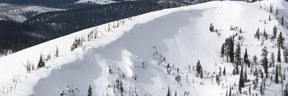
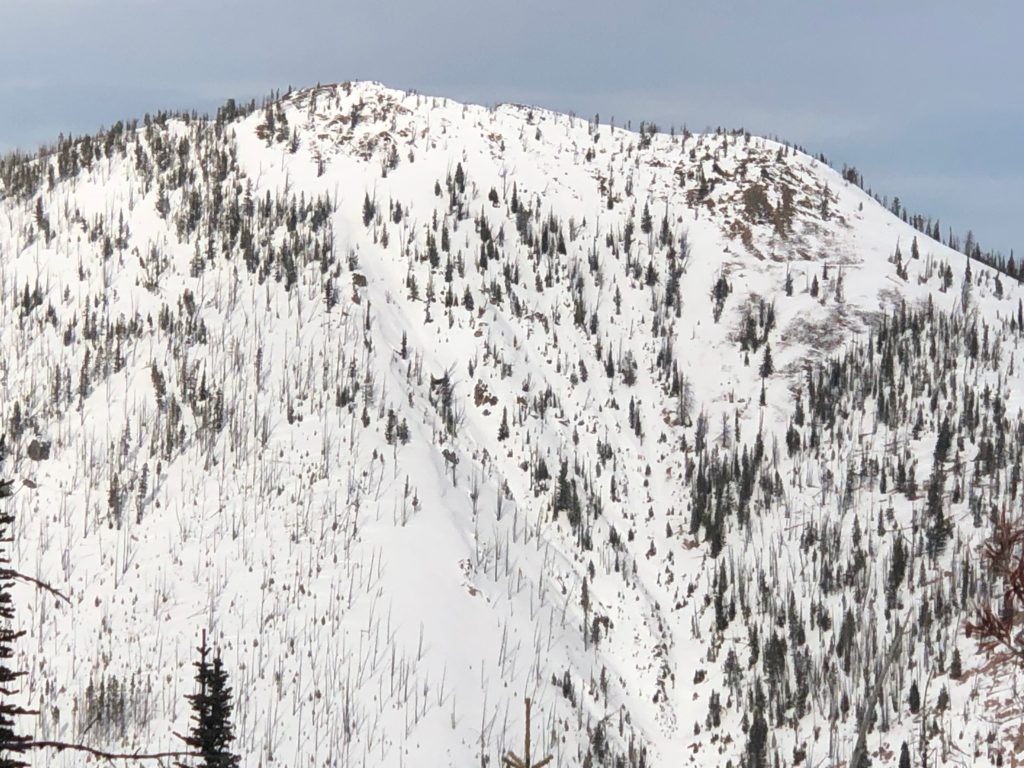
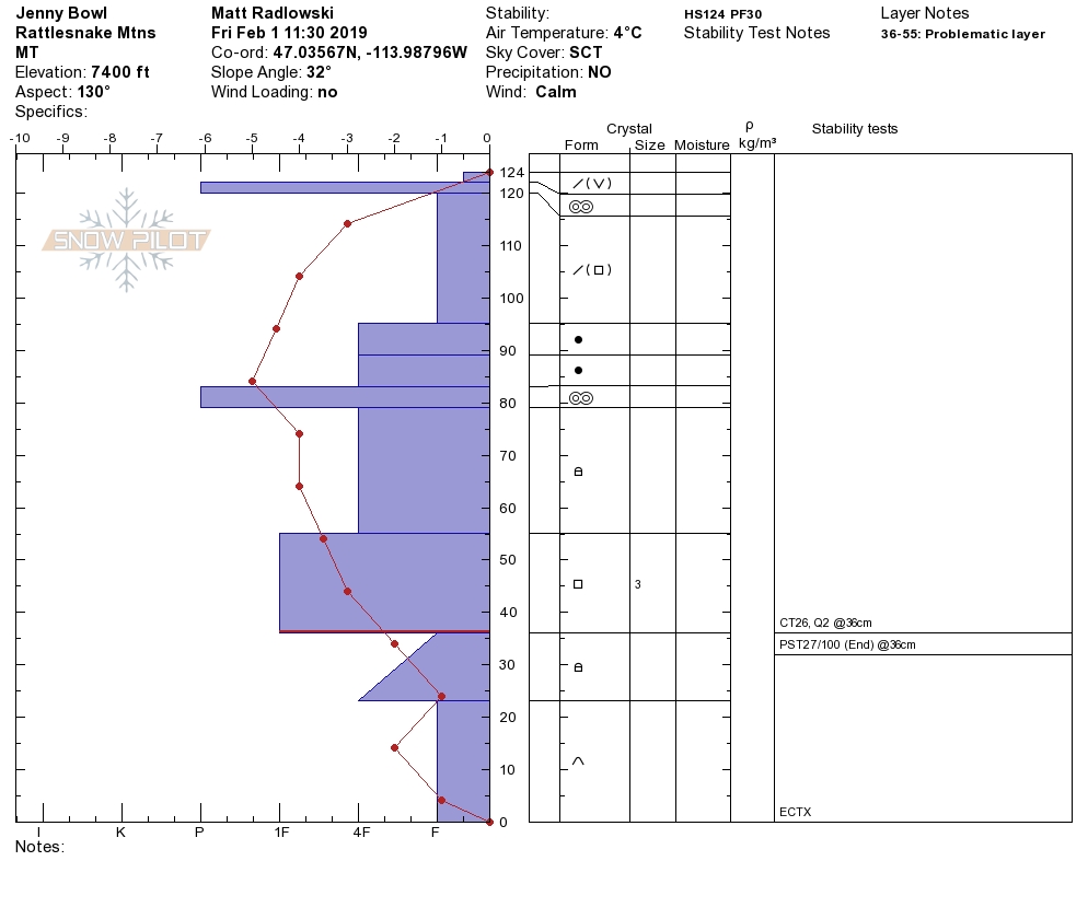
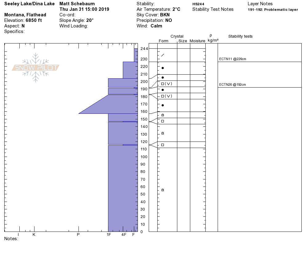
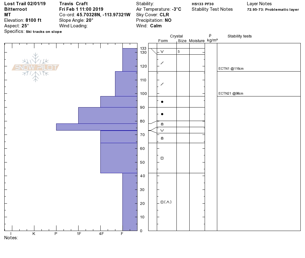
The second avalanche problem is persistent slabs. The snowpack is consolidating, but the layers of buried surface hoar and the facets near the ground are still reactive in shallow snowpacks in pit tests. All of these layers are getting harder to trigger. If you trigger the facets on the ground, it will be a high consequence avalanche. Avoid likely trigger points on slopes(cliff bands, rock outcrops, and slope transitions) where the snowpack is shallow. Choose slopes with clean runout zones that avoid terrain traps(cliffs, trees, and rocks). Dig a pit to see if these layers are present and reactive on the slope.

Bottom line: The snowpack consolidated over the last week. This storm system is predicted to drop a significant amount of snow through the weekend. New snow will be falling on a variety of old snow surfaces and will need time to bond. The weak layers in our snowpack will be tested again with additional loading. Dig a pit to assess the layers of buried surface hoar and facets near the ground. This storm will have strong winds out of the East look for wind drifted snow on leeward slopes.

Avalanche and Weather Outlook

See the forecast here. With the predicted snow totals and wind look for the avalanche danger to increase and go to considerable by Sunday. The new snow will be falling on a variety of old snow surfaces and will need time to bond. The strong winds will load leeward slopes. The persistent weak layers in our snowpack will be tested with new weight being added to them. Keep your head on a swivel and pay close attention to weather changes that will increase the avalanche danger.

As always, if you make it out, please, feel free to share, what you find on our public observations page.

Ski and ride safe.

READ FULL ADVISORY  

Problem 1 - Wind Slabs

  • TYPE

    wind-slabs

    Wind Slabs

    Release of a cohesive layer of snow (a slab) formed by the wind.  Wind typically erodes snow from the upwind sides of terrain features and deposits snow on the downwind side.  Wind slabs are often smooth and rounded and sometimes sound hollow, and can range from soft to hard. Wind slabs that form over a persistent weak layer (surface hoar, depth hoar, or near-surface facets) may be termed Persistent Slabs or may develop into Persistent Slabs.

  • SIZE

    3-4

    1-2 (Small-Large)

    The potential size of avalanche resulting from this problem.

  • LIKELIHOOD

    Likelihood-3

    Possible

    The likelihood of an avalanche resulting from this problem.

Look for smooth rounded pillows and drifts on ridges and cross-loaded slopes. Identify these slopes and avoid traveling on them. These slabs will be sensitive to human triggers today.


Problem 2 - Loose Wet

  • TYPE

    loose-wet

    Loose Wet

    Release of wet unconsolidated snow or slush. These avalanches typically occur within layers of wet snow near the surface of the snowpack, but they may quickly gouge into lower snowpack layers. Like Loose-Dry Avalanches,they start at a point and entrain snow as they move downhill, forming a fan-shaped avalanche. They generally move slowly, but can contain enough mass to cause significant damage to trees, cars or buildings. Other names for loose-wet avalanches include point-release avalanches or sluffs. Loose-wet avalanches can trigger slab avalanches that break into deeper snow layers.

  • SIZE

    2-3

    1 (Small)

    The potential size of avalanche resulting from this problem.

  • LIKELIHOOD

    Likelihood-3

    Possible

    The likelihood of an avalanche resulting from this problem.

The primary concern below 6000 feet is loose wet avalanche activity with warm temperatures and a rain-snow mix. Look for roller balls and avoid slopes that have pinwheels on them. If you are out on a long tour be aware when coming out of higher elevations and heading home.


Problem 3 - Persistent Slabs

  • TYPE

    persistent-slabs

    Persistent Slabs

    Release of a cohesive layer of soft to hard snow (a slab) in the middle to upper snowpack, when the bond to an underlying persistent weak layer breaks.  Persistent layers include: surface hoar, depth hoar, near-surface facets, or faceted snow. Persistent weak layers can continue to produce avalanches for days, weeks or even months, making them especially dangerous and tricky. As additional snow and wind events build a thicker slab on top of the persistent weak layer, this avalanche problem may develop into a Persistent, Deep-Slab.

  • SIZE

    5-6

    2-3 (Large)

    The potential size of avalanche resulting from this problem.

  • LIKELIHOOD

    Likelihood-1

    Unlikely

    The likelihood of an avalanche resulting from this problem.

The snowpack is consolidating but the layers of buried surface hoar and facets near the ground are still reactive in shallow snowpacks in pit tests.

Observations

FORECAST & OUTLOOK

See the forecast here. With the predicted snow totals and wind look for the avalanche danger to increase and go to considerable by Sunday. The new snow will be falling on a variety of old snow surfaces and will need time to bond. The strong winds will load leeward slopes. The persistent weak layers in our snowpack will be tested with new weight being added to them. Keep your head on a swivel and pay close attention to weather changes that will increase the avalanche danger.


This information is the sole responsibility of the Forest Service and does not apply to operating ski areas. The avalanche danger rating expires at midnight tonight but the information can help you make a more informed decision regarding travel in avalanche terrain for the next few days.

Our advisory area includes National Forest System lands in the Bitterroot Mountains from Lost Trail Pass north to Granite Pass, the Rattlesnake Mountains north of Missoula and the Southern Swan and Mission Mountains near Seeley Lake, MT. Avalanche information for the Lookout Pass/St. Regis Basin area is available from the Idaho Panhandle Avalanche Center.