Posted:
Feb 3, 2019 @ 7:01 am

The avalanche danger for the west central Montana backcountry is considerable. Dangerous avalanche conditions are present. Look for the avalanche danger to increase throughout the day, possibly going to High on wind loaded slopes by the afternoon.

Good morning, this is Travis Craft with the West Central Montana Avalanche Center’s avalanche advisory for February 03, 2019. This danger rating does not apply to operating ski areas, expires at midnight tonight and is the sole responsibility of the U.S. Forest Service.

Weather and Snowpack

Mountain temperatures range from 28 F to 34 F. In the Bitterroot winds are 9 mph with gusts of 12 mph out of the SSE. In the northern part of the advisory area, winds are 7 mph and gusting 12 mph out of the ESE. Snotels are reporting between .3 and .5 SWE for the last 24 hours. The arctic front is dropping temperatures, and strong winds are increasing the avalanche danger.

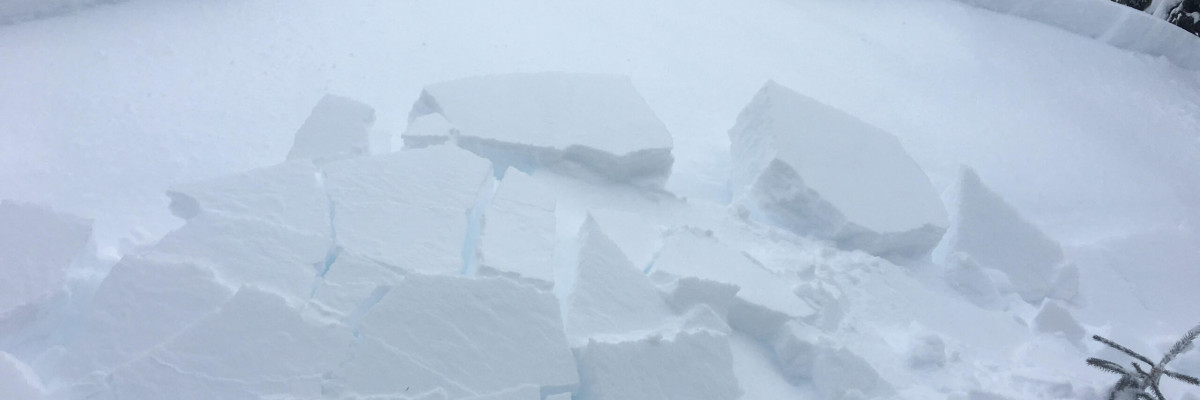
The primary problem today is wind drifted snow. Look for smooth rounded pillows and drifts on ridges and cross-loaded slopes. Identify these slopes and avoid traveling on them. These slabs will be sensitive to human triggers today.

The second problem is new snow on old snow surfaces. There are a variety of old snow surfaces (melt-freeze crusts, surface hoar, and near surface facets) for the new snow to land on. The fresh snow will take time to bond to the old snow.

The last problem is persistent slabs. The new snow will add additional weight to our weak layers in the snowpack and may reactivate some of the layers that have been dormant(facets at the base of our snowpack and buried surface hoar).

Bottom line: We currently have dangerous avalanche conditions in our forecast area. More snow and wind today will increase the avalanche danger throughout the day. Avoid wind drifted terrain. Choose low angle slopes(less than 30 degrees) to enjoy the new snow. It is a real possibility to trigger a wind slab or storm slab on steep terrain and have it step down into the bottom of our snowpack and cause a large or very large avalanche.

Avalanche and Weather Outlook

Snow through Monday. Today 6 to 9 inches of new snow is predicted for the region accompanied by strong winds. These conditions will increase the avalanche danger and may push the avalanche danger to high on wind loaded slopes.  See the forecast here.

As always, if you make it out, please, feel free to share, what you find on our public observations page.

Ski and ride safe.

READ FULL ADVISORY  

Problem 1 - Wind Drifted

  • TYPE

    wind-slabs

    Wind Slabs

    Release of a cohesive layer of snow (a slab) formed by the wind.  Wind typically erodes snow from the upwind sides of terrain features and deposits snow on the downwind side.  Wind slabs are often smooth and rounded and sometimes sound hollow, and can range from soft to hard. Wind slabs that form over a persistent weak layer (surface hoar, depth hoar, or near-surface facets) may be termed Persistent Slabs or may develop into Persistent Slabs.

  • SIZE

    4-5

    2 (Large)

    The potential size of avalanche resulting from this problem.

  • LIKELIHOOD

    Likelihood-5

    Likely

    The likelihood of an avalanche resulting from this problem.

Look for smooth rounded pillows and drifts on ridges and cross-loaded slopes. Identify these slopes and avoid traveling on them. These slabs will be sensitive to human triggers today.

Problem 2 - New Snow

  • TYPE

    storm-slabs

    Storm Slabs

    Release of a soft cohesive layer (a slab) of new snow which breaks within the storm snow or on the old snow surface. Storm-slab problems typically last between a few hours and few days. Storm-slabs that form over a persistent weak layer (surface hoar, depth hoar, or near-surface facets) may be termed Persistent Slabs or may develop into Persistent Slabs.

  • SIZE

    3-4

    1-2 (Small-Large)

    The potential size of avalanche resulting from this problem.

  • LIKELIHOOD

    Likelihood-5

    Likely

    The likelihood of an avalanche resulting from this problem.

The second problem is new snow on old snow surfaces. There are a variety of old snow surfaces (melt-freeze crusts, surface hoar, and near surface facets) for the new snow to land on. The fresh snow will take time to bond to the old snow.


Problem 3 - Persistent Slabs

  • TYPE

    persistent-slabs

    Persistent Slabs

    Release of a cohesive layer of soft to hard snow (a slab) in the middle to upper snowpack, when the bond to an underlying persistent weak layer breaks.  Persistent layers include: surface hoar, depth hoar, near-surface facets, or faceted snow. Persistent weak layers can continue to produce avalanches for days, weeks or even months, making them especially dangerous and tricky. As additional snow and wind events build a thicker slab on top of the persistent weak layer, this avalanche problem may develop into a Persistent, Deep-Slab.

  • SIZE

    6-7

    3 (Large-Very Large)

    The potential size of avalanche resulting from this problem.

  • LIKELIHOOD

    Likelihood-3

    Possible

    The likelihood of an avalanche resulting from this problem.

The new snow will add additional weight to our weak layers in the snowpack and may reactivate some of the layers that have been dormant(facets at the base of our snowpack and buried surface hoar).

FORECAST & OUTLOOK

Snow through Monday. Today 6 to 9 inches of new snow is predicted for the region accompanied by strong winds. These conditions will increase the avalanche danger and may push the avalanche danger to high on wind loaded slopes.  See the forecast here.

This information is the sole responsibility of the Forest Service and does not apply to operating ski areas. The avalanche danger rating expires at midnight tonight but the information can help you make a more informed decision regarding travel in avalanche terrain for the next few days.

Our advisory area includes National Forest System lands in the Bitterroot Mountains from Lost Trail Pass north to Granite Pass, the Rattlesnake Mountains north of Missoula and the Southern Swan and Mission Mountains near Seeley Lake, MT. Avalanche information for the Lookout Pass/St. Regis Basin area is available from the Idaho Panhandle Avalanche Center.