Posted:
Feb 9, 2019 @ 6:35 am

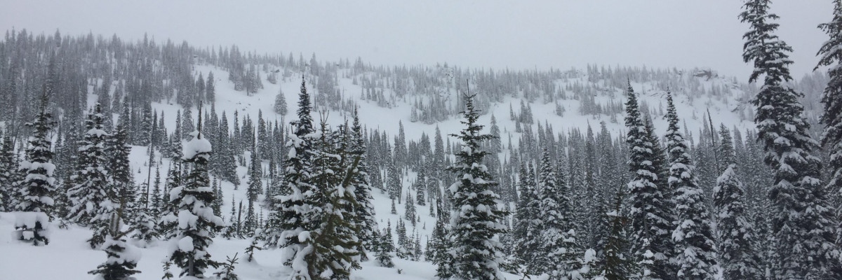
A MODERATE avalanche danger exists for the West Central Montana backcountry. Developing winds and snowfall have increased the avalanche danger and will continue to do so through the day today, possibly rising to considerable on wind loaded terrain by this afternoon. Human triggered avalanches are possible this morning and will be trending up throughout the day today. Currently, avalanches are confined to isolated terrain but will become more widespread.

Good morning, this is Logan King with the West Central Montana Avalanche Center’s avalanche advisory for Saturday, February 9th, 2019. This danger rating does not apply to operating ski areas, expires at midnight tonight and is the sole responsibility of the U.S. Forest Service.

Weather and Snowpack

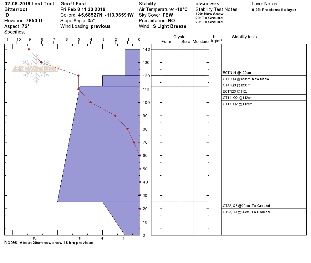
An arctic air mass is moving across the forecast area today dropping temperatures and bringing strong easterly winds. The northern half of the region is already seeing the impacts of the arctic air with temperatures this morning ranging from -5 to -10 Fahrenheit. Winds are out of the ENE at 18 mph with gusts of 36 mph. Further south the winds are out of the SE at 9 mph and gusting to 16 mph. Temperatures for the southern half of the forecast area are 7 to 16 degrees F. Yesterday we received 1-3 inches of snow and overnight some locations received another 1-2 inches. SWE’s are low with cold conditions ,and the falling snow is light and dry.

Wind slabs are the most likely type of avalanche of consequence to be triggered this morning. Winds picked up yesterday evening and have been building wind slabs overnight specifically for the northern portion of the advisory area. Winds are setting up out of the East again and will have unusual loading patterns. Cross loading will create hidden problems that are hard to identify and wind slabs will only grow in size and sensitivity to triggers as the day progresses.

Widespread loose snow avalanches will continue to be problematic specifically in areas with terrain traps that increase the consequences of a slide. The sluffs may develop into small storm slabs as more snow falls and builds the slab through the weekend. Similar to last weekend the new snow is very cold and dry, as additional snow is added to the snowpack keep an eye on how the new snow bonds to the old snow surface.

Keep in mind that as persistent slabs are gaining strength and have become less reactive, loading events like the one expected this weekend have the potential to re-activate weak layers. The layers of buried surface hoar are less widespread and reactive but should be considered today as they will be under increased stress. The facets near the ground are hopefully nearing the end of their activity as we have not been able to find them reactive for nearly a week.

Avalanche and Weather Outlook

Scattered snow showers will develop through the day today bringing an additional inch or two of snow by tonight. Strong easterly flow will sustain the strong winds. Temperatures look to drop further south as the arctic air continues to move south and west. A pattern of a few additional inches daily and cold temperatures looks to persist for the next week (forecast). Avalanche danger will be increasing specifically on wind loaded terrain today. The danger will slowly increase on all other terrain as well, as more snow is added to the snowpack over the weekend.

As always, if you make it out, please, feel free to share, what you find on our public observations page.

Ski and ride safe.

READ FULL ADVISORY  

Problem 1 - Wind Drifted Snow

  • TYPE

    wind-slabs

    Wind Slabs

    Release of a cohesive layer of snow (a slab) formed by the wind.  Wind typically erodes snow from the upwind sides of terrain features and deposits snow on the downwind side.  Wind slabs are often smooth and rounded and sometimes sound hollow, and can range from soft to hard. Wind slabs that form over a persistent weak layer (surface hoar, depth hoar, or near-surface facets) may be termed Persistent Slabs or may develop into Persistent Slabs.

  • SIZE

    2-3

    1 (Small)

    The potential size of avalanche resulting from this problem.

  • LIKELIHOOD

    Likelihood-4

    Possible/Likely

    The likelihood of an avalanche resulting from this problem.

Strong winds overnight and continuing through the day are building wind slabs that will be sensitive to human triggers.

Problem 2 - Loose Snow

  • TYPE

    loose-dry

    Loose Dry

    Release of wet unconsolidated snow or slush. These avalanches typically occur within layers of wet snow near the surface of the snowpack, but they may quickly gouge into lower snowpack layers. Like Loose-Dry Avalanches,they start at a point and entrain snow as they move downhill, forming a fan-shaped avalanche. They generally move slowly, but can contain enough mass to cause significant damage to trees, cars or buildings. Other names for loose-wet avalanches include point-release avalanches or sluffs. Loose-wet avalanches can trigger slab avalanches that break into deeper snow layers.

  • SIZE

    1-2

    < 1 (Small)

    The potential size of avalanche resulting from this problem.

  • LIKELIHOOD

    Likelihood-4

    Possible/Likely

    The likelihood of an avalanche resulting from this problem.

Small sluffs will easily be triggered in terrain steeper than 35 degrees.

Problem 3 - Persistent Slabs

  • TYPE

    persistent-slabs

    Persistent Slabs

    Release of a cohesive layer of soft to hard snow (a slab) in the middle to upper snowpack, when the bond to an underlying persistent weak layer breaks.  Persistent layers include: surface hoar, depth hoar, near-surface facets, or faceted snow. Persistent weak layers can continue to produce avalanches for days, weeks or even months, making them especially dangerous and tricky. As additional snow and wind events build a thicker slab on top of the persistent weak layer, this avalanche problem may develop into a Persistent, Deep-Slab.

  • SIZE

    3-4

    1-2 (Small-Large)

    The potential size of avalanche resulting from this problem.

  • LIKELIHOOD

    Likelihood-2

    Unlikely/Possible

    The likelihood of an avalanche resulting from this problem.

Buried surface hoar and facets continue to gain strength but can be reactive in isolated locations.

VIDEO

FORECAST & OUTLOOK

Dropping temperatures and developing winds will make for cold conditions for the weekend. Light snowfall is expected with 1-2 inches today and tonight.

This information is the sole responsibility of the Forest Service and does not apply to operating ski areas. The avalanche danger rating expires at midnight tonight but the information can help you make a more informed decision regarding travel in avalanche terrain for the next few days.

Our advisory area includes National Forest System lands in the Bitterroot Mountains from Lost Trail Pass north to Granite Pass, the Rattlesnake Mountains north of Missoula and the Southern Swan and Mission Mountains near Seeley Lake, MT. Avalanche information for the Lookout Pass/St. Regis Basin area is available from the Idaho Panhandle Avalanche Center.