Posted:
Feb 27, 2019 @ 6:08 am

The Avalanche warning is terminated. The avalanche danger for the west central Montana backcountry is CONSIDERABLE.  Dangerous avalanche conditions are present. Look for the avalanche danger to increase throughout the day, possibly going to HIGH on wind loaded slopes by the afternoon.

Good morning, this is Travis Craft with the West Central Montana Avalanche Center’s avalanche advisory for February 27, 2019. This danger rating does not apply to operating ski areas, expires at midnight tonight and is the sole responsibility of the U.S. Forest Service.

Weather and Snowpack

Mountain temperatures range from 4 F to 16 F in the region. In the Bitterroot winds are 9 mph with gusts of 12 out of the SSE. In the northern part of the advisory area, winds are 7 mph and gusting 21 mph out of the East. Snotels are reporting between .1 and .2 inches of SWE for the last 24 hours.

Yesterday allowed the snowpack to adjust to the weight of the new snow. Winds have loaded leeward slopes.

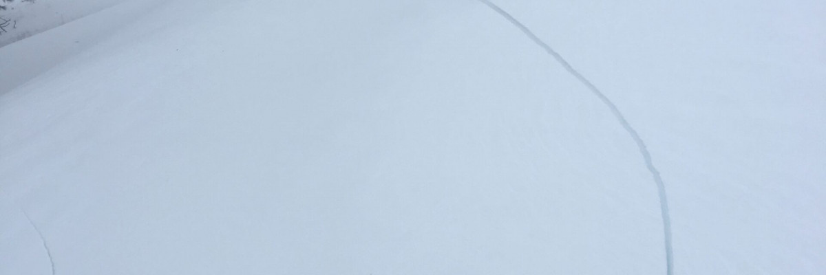
The primary avalanche problem is wind drifted snow on leeward slopes. Shifting winds have deposited snow in unusual spots. Look for wind slabs on cross-loaded slopes and ridges. Pay attention to slopes at low and mid elevations which have been wind loaded. Identify these slopes and avoid traveling on them. These slabs will be sensitive to human triggers today.

The second problem is persistent slabs. The storm dropped a significant load of snow on our buried weak layers. These layers are guilty until proven innocent. Dig a pit that is 4 feet down and see if buried surface hoar is present and reactive. Look for shooting cracks, natural activity, and collapses; these are clues to instabilities in the snowpack.

The last avalanche problem is storm slabs. The forecast area has received a significant amount of new snow from the last storm. The snowpack is adjusting to the new load. Shooting cracks and natural avalanche activity are red flags of instability. Use small test slopes with low consequences to see how the new snow is bonding to old snow surfaces.

Bottom line: Dangerous avalanche conditions exist today.  Avoid traveling on and under wind loaded slopes. New snow will be sensitive to human triggers. Use test slopes and lower angle terrain to check the bonding of new snow to old snow surfaces. Pay attention to changing conditions and look for red flags(shooting cracks, natural avalanche activity, collapsing, and new loading). Dig a pit 4 feet down to check for the dragons lurking(weak layers) in our snowpack. Choose lower angle terrain(less than 30 degrees).

Avalanche and Weather Outlook

Snow today accompanied with wind. See the forecast here. New snow and wind will increase the avalanche danger. Pay attention to changing weather conditions and avalanche conditions. Look for shooting cracks, natural activity, and collapses; these are clues to instabilities in the snowpack. Choose lower angle terrain(less than 30 degrees).

As always, if you make it out, please, feel free to share, what you find on our public observations page.

Ski and ride safe.

READ FULL ADVISORY  

Problem 1 - Wind Drifted Snow

  • TYPE

    wind-slabs

    Wind Slabs

    Release of a cohesive layer of snow (a slab) formed by the wind.  Wind typically erodes snow from the upwind sides of terrain features and deposits snow on the downwind side.  Wind slabs are often smooth and rounded and sometimes sound hollow, and can range from soft to hard. Wind slabs that form over a persistent weak layer (surface hoar, depth hoar, or near-surface facets) may be termed Persistent Slabs or may develop into Persistent Slabs.

  • SIZE

    4-5

    2 (Large)

    The potential size of avalanche resulting from this problem.

  • LIKELIHOOD

    Likelihood-5

    Likely

    The likelihood of an avalanche resulting from this problem.

Shifting winds have deposited snow in unusual spots. Look for wind slabs on cross-loaded slopes and ridges. Pay attention to slopes at low and mid elevations which have been wind loaded. Identify these slopes and avoid traveling on them. These slabs will be sensitive to human triggers today.


Problem 2 - Persistent Slabs

  • TYPE

    persistent-slabs

    Persistent Slabs

    Release of a cohesive layer of soft to hard snow (a slab) in the middle to upper snowpack, when the bond to an underlying persistent weak layer breaks.  Persistent layers include: surface hoar, depth hoar, near-surface facets, or faceted snow. Persistent weak layers can continue to produce avalanches for days, weeks or even months, making them especially dangerous and tricky. As additional snow and wind events build a thicker slab on top of the persistent weak layer, this avalanche problem may develop into a Persistent, Deep-Slab.

  • SIZE

    5-6

    2-3 (Large)

    The potential size of avalanche resulting from this problem.

  • LIKELIHOOD

    Likelihood-4

    Possible/Likely

    The likelihood of an avalanche resulting from this problem.

The storm dropped a significant load of snow on our buried weak layers. These layers are guilty until proven innocent. Dig a pit that is 4 feet down and see if buried surface hoar is present and reactive. Look for shooting cracks, natural activity, and collapses; these are clues to instabilities in the snowpack.

Problem 3 - Storm Slabs

  • TYPE

    storm-slabs

    Storm Slabs

    Release of a soft cohesive layer (a slab) of new snow which breaks within the storm snow or on the old snow surface. Storm-slab problems typically last between a few hours and few days. Storm-slabs that form over a persistent weak layer (surface hoar, depth hoar, or near-surface facets) may be termed Persistent Slabs or may develop into Persistent Slabs.

  • SIZE

    6-7

    3 (Large-Very Large)

    The potential size of avalanche resulting from this problem.

  • LIKELIHOOD

    Likelihood-4

    Possible/Likely

    The likelihood of an avalanche resulting from this problem.

The forecast area has received a significant amount of new snow from the last storm. The snowpack is adjusting to the new load. Shooting cracks and natural avalanche activity are red flags of instability. Use small test slopes with low consequences to see how the new snow is bonding to old snow surfaces.


FORECAST & OUTLOOK

Snow today accompanied with wind. See the forecast here. New snow and wind will increase the avalanche danger. Pay attention to changing weather conditions and avalanche conditions. Look for shooting cracks, natural activity, and collapses; these are clues to instabilities in the snowpack. Choose lower angle terrain(less than 30 degrees).


This information is the sole responsibility of the Forest Service and does not apply to operating ski areas. The avalanche danger rating expires at midnight tonight but the information can help you make a more informed decision regarding travel in avalanche terrain for the next few days.

Our advisory area includes National Forest System lands in the Bitterroot Mountains from Lost Trail Pass north to Granite Pass, the Rattlesnake Mountains north of Missoula and the Southern Swan and Mission Mountains near Seeley Lake, MT. Avalanche information for the Lookout Pass/St. Regis Basin area is available from the Idaho Panhandle Avalanche Center.